Map: Iron Age Anatolia – Anatolia (mid000008)

[vc_row fullwidth=”true” attached=”true” css=”.vc_custom_1590517688211{padding-top: 0px !important;padding-right: 0px !important;padding-bottom: 0px !important;padding-left: 0px !important;}”][vc_column][vc_single_image image=”61485″ img_size=”1920×600″ alignment=”center”][/vc_column][/vc_row][vc_row][vc_column][vc_column_text][/vc_column_text][/vc_column][/vc_row][vc_row fullwidth=”true” css=”.vc_custom_1490225468623{padding-top: 0px !important;padding-right: 0px !important;padding-bottom: 0px !important;padding-left: 0px !important;}”][vc_column width=”1/12″ css=”.vc_custom_1490225195470{margin-right: 10px !important;}” offset=”vc_hidden-sm vc_hidden-xs”][vc_column_text]

  SHARE

[/vc_column_text][mk_image src=”http://www.asortest.org/wp-content/uploads/2017/01/social-fb-icon4.jpg” image_width=”42″ image_height=”42″ hover=”false” custom_url=”https://www.facebook.com/ASOResearch/” margin_bottom=”0″][mk_image src=”http://www.asortest.org/wp-content/uploads/2017/01/social-tw-icon4.jpg” image_width=”42″ image_height=”42″ hover=”false” custom_url=”https://twitter.com/ASOResearch?ref_src=twsrc%5Egoogle%7Ctwcamp%5Eserp%7Ctwgr%5Eauthor” margin_bottom=”0″][mk_image src=”http://www.asortest.org/wp-content/uploads/2017/01/social-in-icon4.jpg” image_width=”42″ image_height=”42″ hover=”false” custom_url=”https://www.linkedin.com/company/american-schools-of-oriental-research” margin_bottom=”0″][mk_image src=”http://www.asortest.org/wp-content/uploads/2017/01/social-ml-icon_7.jpg” image_width=”42″ image_height=”42″ hover=”false” custom_url=”mailto:info@asor.org” margin_bottom=”0″][mk_image src=”http://www.asortest.org/wp-content/uploads/2017/01/blog-icon3.jpg” image_width=”42″ image_height=”42″ hover=”false” custom_url=”http://asor.org/blog” margin_bottom=”0″][/vc_column][vc_column border_color=”rgba(255,255,255,0.01)” width=”1/6″ css=”.vc_custom_1490365673198{margin-right: 20px !important;border-left-width: 2px !important;padding-right: 20px !important;padding-left: 20px !important;border-left-color: #99422f !important;}” el_class=”sticky-sidenav”][mk_divider divider_color=”rgba(255,255,255,0.01)” thickness=”1″ margin_top=”3″ margin_bottom=”3″][vc_widget_sidebar sidebar_id=”ca-sidebar-60550″ el_class=”.widget { overflow: hidden; margin-bottom: 0; }”][/vc_column][vc_column border_color=”rgba(170,170,170,0.01)” width=”8/12″ css=”.vc_custom_1490225606852{margin-right: 10px !important;margin-bottom: 30px !important;border-right-width: 2px !important;border-bottom-width: 2px !important;padding-top: 30px !important;padding-right: 30px !important;padding-left: 20px !important;background-color: #ffffff !important;border-right-color: rgba(227,228,228,0.75) !important;border-bottom-color: rgba(227,228,228,0.75) !important;}”][vc_row_inner][vc_column_inner width=”1/4″ css=”.vc_custom_1590517099925{margin-right: 20px !important;}”][vc_single_image image=”61117″ img_size=”full”][/vc_column_inner][vc_column_inner width=”3/4″][vc_wp_text]
ONLINE RESOURCES

ASOR Map Collections

[/vc_wp_text][/vc_column_inner][/vc_row_inner][mk_divider thickness=”1″ margin_top=”10″ margin_bottom=”10″][vc_row_inner][vc_column_inner width=”2/3″ css=”.vc_custom_1590550959746{padding-top: 30px !important;padding-right: 40px !important;}”][vc_single_image image=”69616″ img_size=”600 x 393″ onclick=”img_link_large” img_link_target=”_blank”][mk_padding_divider size=”10″][vc_wp_text]
Map ID: MID000008 – Download Image
[/vc_wp_text][/vc_column_inner][vc_column_inner width=”1/3″][vc_wp_text]
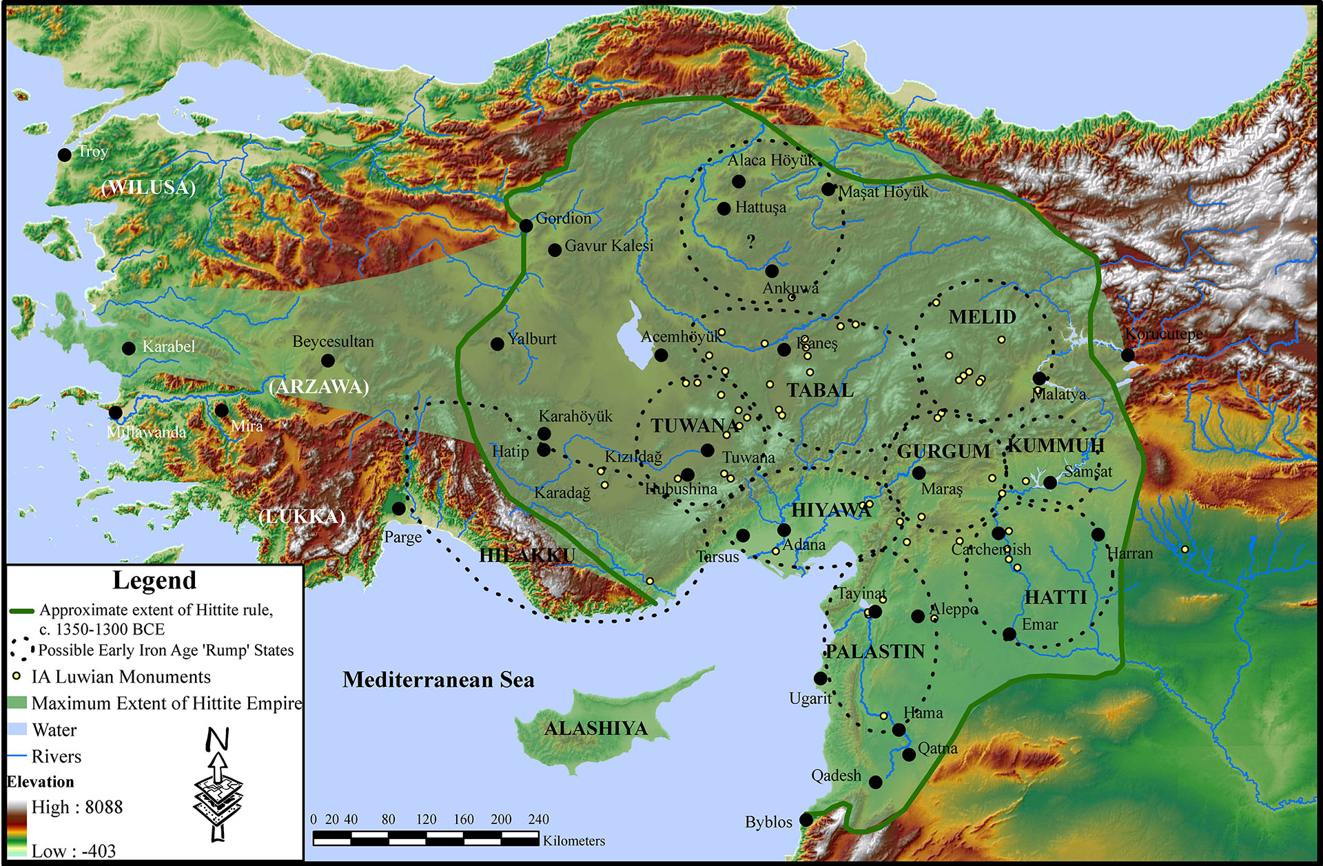
Map: Iron Age Anatolia

Region: Anatolia
Description:
Topographical site map of Anatolia with possible “Rump” States noted with dashed lines
Category: Maps
Type: Site Maps, Topographic Maps
Period: Iron Age
Date: 1200 – 550 BCE
Credit: Stephen Batiuk, September 2011

Back to Browsing Maps[/vc_wp_text][/vc_column_inner][/vc_row_inner][mk_divider thickness=”1″ margin_top=”30″ margin_bottom=”30″][vc_row_inner][vc_column_inner css=”.vc_custom_1590517110399{padding-right: 20px !important;padding-bottom: 20px !important;}”][vc_widget_sidebar sidebar_id=”ca-sidebar-64142″][/vc_column_inner][/vc_row_inner][mk_divider thickness=”1″ margin_top=”30″][vc_widget_sidebar sidebar_id=”ca-sidebar-62968″][mk_padding_divider size=”20″][/vc_column][/vc_row][vc_row][vc_column][vc_column_text] [/vc_column_text][/vc_column][/vc_row]

Map: Iron Age Central and Western Iran – Mesopotamia (mid000007)

[vc_row fullwidth=”true” attached=”true” css=”.vc_custom_1590517688211{padding-top: 0px !important;padding-right: 0px !important;padding-bottom: 0px !important;padding-left: 0px !important;}”][vc_column][vc_single_image image=”61485″ img_size=”1920×600″ alignment=”center”][/vc_column][/vc_row][vc_row][vc_column][vc_column_text][/vc_column_text][/vc_column][/vc_row][vc_row fullwidth=”true” css=”.vc_custom_1490225468623{padding-top: 0px !important;padding-right: 0px !important;padding-bottom: 0px !important;padding-left: 0px !important;}”][vc_column width=”1/12″ css=”.vc_custom_1490225195470{margin-right: 10px !important;}” offset=”vc_hidden-sm vc_hidden-xs”][vc_column_text]

  SHARE

[/vc_column_text][mk_image src=”http://www.asortest.org/wp-content/uploads/2017/01/social-fb-icon4.jpg” image_width=”42″ image_height=”42″ hover=”false” custom_url=”https://www.facebook.com/ASOResearch/” margin_bottom=”0″][mk_image src=”http://www.asortest.org/wp-content/uploads/2017/01/social-tw-icon4.jpg” image_width=”42″ image_height=”42″ hover=”false” custom_url=”https://twitter.com/ASOResearch?ref_src=twsrc%5Egoogle%7Ctwcamp%5Eserp%7Ctwgr%5Eauthor” margin_bottom=”0″][mk_image src=”http://www.asortest.org/wp-content/uploads/2017/01/social-in-icon4.jpg” image_width=”42″ image_height=”42″ hover=”false” custom_url=”https://www.linkedin.com/company/american-schools-of-oriental-research” margin_bottom=”0″][mk_image src=”http://www.asortest.org/wp-content/uploads/2017/01/social-ml-icon_7.jpg” image_width=”42″ image_height=”42″ hover=”false” custom_url=”mailto:info@asor.org” margin_bottom=”0″][mk_image src=”http://www.asortest.org/wp-content/uploads/2017/01/blog-icon3.jpg” image_width=”42″ image_height=”42″ hover=”false” custom_url=”http://asor.org/blog” margin_bottom=”0″][/vc_column][vc_column border_color=”rgba(255,255,255,0.01)” width=”1/6″ css=”.vc_custom_1490365673198{margin-right: 20px !important;border-left-width: 2px !important;padding-right: 20px !important;padding-left: 20px !important;border-left-color: #99422f !important;}” el_class=”sticky-sidenav”][mk_divider divider_color=”rgba(255,255,255,0.01)” thickness=”1″ margin_top=”3″ margin_bottom=”3″][vc_widget_sidebar sidebar_id=”ca-sidebar-60550″ el_class=”.widget { overflow: hidden; margin-bottom: 0; }”][/vc_column][vc_column border_color=”rgba(170,170,170,0.01)” width=”8/12″ css=”.vc_custom_1490225606852{margin-right: 10px !important;margin-bottom: 30px !important;border-right-width: 2px !important;border-bottom-width: 2px !important;padding-top: 30px !important;padding-right: 30px !important;padding-left: 20px !important;background-color: #ffffff !important;border-right-color: rgba(227,228,228,0.75) !important;border-bottom-color: rgba(227,228,228,0.75) !important;}”][vc_row_inner][vc_column_inner width=”1/4″ css=”.vc_custom_1590517099925{margin-right: 20px !important;}”][vc_single_image image=”61117″ img_size=”full”][/vc_column_inner][vc_column_inner width=”3/4″][vc_wp_text]
ONLINE RESOURCES

ASOR Map Collections

[/vc_wp_text][/vc_column_inner][/vc_row_inner][mk_divider thickness=”1″ margin_top=”10″ margin_bottom=”10″][vc_row_inner][vc_column_inner width=”2/3″ css=”.vc_custom_1590550959746{padding-top: 30px !important;padding-right: 40px !important;}”][vc_single_image image=”69614″ img_size=”464 x 600″ onclick=”img_link_large” img_link_target=”_blank”][mk_padding_divider size=”10″][vc_wp_text]
Map ID: MID000007 – Download Image
[/vc_wp_text][/vc_column_inner][vc_column_inner width=”1/3″][vc_wp_text]

Map: Iron Age Central and Western Iran

Region: Mesopotamia
Description:
Topographical site map of Central and West Iran
Category: Maps
Type: Site Maps, Topographic Maps
Period: Iron Age
Date: 1200 – 550 BCE
Credit: Stephen Batiuk, September 2011

Back to Browsing Maps[/vc_wp_text][/vc_column_inner][/vc_row_inner][mk_divider thickness=”1″ margin_top=”30″ margin_bottom=”30″][vc_row_inner][vc_column_inner css=”.vc_custom_1590517110399{padding-right: 20px !important;padding-bottom: 20px !important;}”][vc_widget_sidebar sidebar_id=”ca-sidebar-64142″][/vc_column_inner][/vc_row_inner][mk_divider thickness=”1″ margin_top=”30″][vc_widget_sidebar sidebar_id=”ca-sidebar-62968″][mk_padding_divider size=”20″][/vc_column][/vc_row][vc_row][vc_column][vc_column_text] [/vc_column_text][/vc_column][/vc_row]
Map: Kingdoms and Regions of the Hellenistic Levant and Mesopotamia – Near East (mid000006)

[vc_row fullwidth=”true” attached=”true” css=”.vc_custom_1590517688211{padding-top: 0px !important;padding-right: 0px !important;padding-bottom: 0px !important;padding-left: 0px !important;}”][vc_column][vc_single_image image=”61485″ img_size=”1920×600″ alignment=”center”][/vc_column][/vc_row][vc_row][vc_column][vc_column_text][/vc_column_text][/vc_column][/vc_row][vc_row fullwidth=”true” css=”.vc_custom_1490225468623{padding-top: 0px !important;padding-right: 0px !important;padding-bottom: 0px !important;padding-left: 0px !important;}”][vc_column width=”1/12″ css=”.vc_custom_1490225195470{margin-right: 10px !important;}” offset=”vc_hidden-sm vc_hidden-xs”][vc_column_text]

  SHARE

[/vc_column_text][mk_image src=”http://www.asortest.org/wp-content/uploads/2017/01/social-fb-icon4.jpg” image_width=”42″ image_height=”42″ hover=”false” custom_url=”https://www.facebook.com/ASOResearch/” margin_bottom=”0″][mk_image src=”http://www.asortest.org/wp-content/uploads/2017/01/social-tw-icon4.jpg” image_width=”42″ image_height=”42″ hover=”false” custom_url=”https://twitter.com/ASOResearch?ref_src=twsrc%5Egoogle%7Ctwcamp%5Eserp%7Ctwgr%5Eauthor” margin_bottom=”0″][mk_image src=”http://www.asortest.org/wp-content/uploads/2017/01/social-in-icon4.jpg” image_width=”42″ image_height=”42″ hover=”false” custom_url=”https://www.linkedin.com/company/american-schools-of-oriental-research” margin_bottom=”0″][mk_image src=”http://www.asortest.org/wp-content/uploads/2017/01/social-ml-icon_7.jpg” image_width=”42″ image_height=”42″ hover=”false” custom_url=”mailto:info@asor.org” margin_bottom=”0″][mk_image src=”http://www.asortest.org/wp-content/uploads/2017/01/blog-icon3.jpg” image_width=”42″ image_height=”42″ hover=”false” custom_url=”http://asor.org/blog” margin_bottom=”0″][/vc_column][vc_column border_color=”rgba(255,255,255,0.01)” width=”1/6″ css=”.vc_custom_1490365673198{margin-right: 20px !important;border-left-width: 2px !important;padding-right: 20px !important;padding-left: 20px !important;border-left-color: #99422f !important;}” el_class=”sticky-sidenav”][mk_divider divider_color=”rgba(255,255,255,0.01)” thickness=”1″ margin_top=”3″ margin_bottom=”3″][vc_widget_sidebar sidebar_id=”ca-sidebar-60550″ el_class=”.widget { overflow: hidden; margin-bottom: 0; }”][/vc_column][vc_column border_color=”rgba(170,170,170,0.01)” width=”8/12″ css=”.vc_custom_1490225606852{margin-right: 10px !important;margin-bottom: 30px !important;border-right-width: 2px !important;border-bottom-width: 2px !important;padding-top: 30px !important;padding-right: 30px !important;padding-left: 20px !important;background-color: #ffffff !important;border-right-color: rgba(227,228,228,0.75) !important;border-bottom-color: rgba(227,228,228,0.75) !important;}”][vc_row_inner][vc_column_inner width=”1/4″ css=”.vc_custom_1590517099925{margin-right: 20px !important;}”][vc_single_image image=”61117″ img_size=”full”][/vc_column_inner][vc_column_inner width=”3/4″][vc_wp_text]
ONLINE RESOURCES

ASOR Map Collections

[/vc_wp_text][/vc_column_inner][/vc_row_inner][mk_divider thickness=”1″ margin_top=”10″ margin_bottom=”10″][vc_row_inner][vc_column_inner width=”2/3″ css=”.vc_custom_1590550959746{padding-top: 30px !important;padding-right: 40px !important;}”][vc_single_image image=”69612″ img_size=”600 x 468″ onclick=”img_link_large” img_link_target=”_blank”][mk_padding_divider size=”10″][vc_wp_text]
Map ID: MID000006 – Download Image
[/vc_wp_text][/vc_column_inner][vc_column_inner width=”1/3″][vc_wp_text]

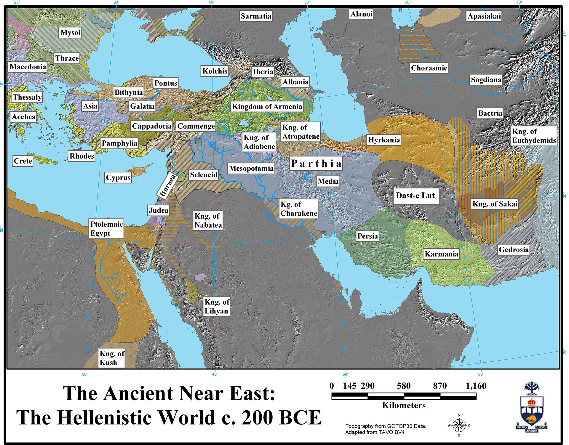
Map: Kingdoms and Regions of the Hellenistic Levant and Mesopotamia

Region: Levant, Mesopotamia, and Egypt
Description:
Map of the various kingdoms and regions of the Hellenistic ancient Near East
Category: Maps
Type: Kingdom and Empire Maps
Period: Hellenistic
Date: 200 BCE
Credit: Stephen Batiuk, January 2005

Back to Browsing Maps[/vc_wp_text][/vc_column_inner][/vc_row_inner][mk_divider thickness=”1″ margin_top=”30″ margin_bottom=”30″][vc_row_inner][vc_column_inner css=”.vc_custom_1590517110399{padding-right: 20px !important;padding-bottom: 20px !important;}”][vc_widget_sidebar sidebar_id=”ca-sidebar-64142″][/vc_column_inner][/vc_row_inner][mk_divider thickness=”1″ margin_top=”30″][vc_widget_sidebar sidebar_id=”ca-sidebar-62968″][mk_padding_divider size=”20″][/vc_column][/vc_row][vc_row][vc_column][vc_column_text] [/vc_column_text][/vc_column][/vc_row]
Map: Kingdoms and Regions of the Hellenistic Greece and Anatolia – Aegean and Anatolia (mid000005)

[vc_row fullwidth=”true” attached=”true” css=”.vc_custom_1590517688211{padding-top: 0px !important;padding-right: 0px !important;padding-bottom: 0px !important;padding-left: 0px !important;}”][vc_column][vc_single_image image=”61485″ img_size=”1920×600″ alignment=”center”][/vc_column][/vc_row][vc_row][vc_column][vc_column_text][/vc_column_text][/vc_column][/vc_row][vc_row fullwidth=”true” css=”.vc_custom_1490225468623{padding-top: 0px !important;padding-right: 0px !important;padding-bottom: 0px !important;padding-left: 0px !important;}”][vc_column width=”1/12″ css=”.vc_custom_1490225195470{margin-right: 10px !important;}” offset=”vc_hidden-sm vc_hidden-xs”][vc_column_text]

  SHARE

[/vc_column_text][mk_image src=”http://www.asortest.org/wp-content/uploads/2017/01/social-fb-icon4.jpg” image_width=”42″ image_height=”42″ hover=”false” custom_url=”https://www.facebook.com/ASOResearch/” margin_bottom=”0″][mk_image src=”http://www.asortest.org/wp-content/uploads/2017/01/social-tw-icon4.jpg” image_width=”42″ image_height=”42″ hover=”false” custom_url=”https://twitter.com/ASOResearch?ref_src=twsrc%5Egoogle%7Ctwcamp%5Eserp%7Ctwgr%5Eauthor” margin_bottom=”0″][mk_image src=”http://www.asortest.org/wp-content/uploads/2017/01/social-in-icon4.jpg” image_width=”42″ image_height=”42″ hover=”false” custom_url=”https://www.linkedin.com/company/american-schools-of-oriental-research” margin_bottom=”0″][mk_image src=”http://www.asortest.org/wp-content/uploads/2017/01/social-ml-icon_7.jpg” image_width=”42″ image_height=”42″ hover=”false” custom_url=”mailto:info@asor.org” margin_bottom=”0″][mk_image src=”http://www.asortest.org/wp-content/uploads/2017/01/blog-icon3.jpg” image_width=”42″ image_height=”42″ hover=”false” custom_url=”http://asor.org/blog” margin_bottom=”0″][/vc_column][vc_column border_color=”rgba(255,255,255,0.01)” width=”1/6″ css=”.vc_custom_1490365673198{margin-right: 20px !important;border-left-width: 2px !important;padding-right: 20px !important;padding-left: 20px !important;border-left-color: #99422f !important;}” el_class=”sticky-sidenav”][mk_divider divider_color=”rgba(255,255,255,0.01)” thickness=”1″ margin_top=”3″ margin_bottom=”3″][vc_widget_sidebar sidebar_id=”ca-sidebar-60550″ el_class=”.widget { overflow: hidden; margin-bottom: 0; }”][/vc_column][vc_column border_color=”rgba(170,170,170,0.01)” width=”8/12″ css=”.vc_custom_1490225606852{margin-right: 10px !important;margin-bottom: 30px !important;border-right-width: 2px !important;border-bottom-width: 2px !important;padding-top: 30px !important;padding-right: 30px !important;padding-left: 20px !important;background-color: #ffffff !important;border-right-color: rgba(227,228,228,0.75) !important;border-bottom-color: rgba(227,228,228,0.75) !important;}”][vc_row_inner][vc_column_inner width=”1/4″ css=”.vc_custom_1590517099925{margin-right: 20px !important;}”][vc_single_image image=”61117″ img_size=”full”][/vc_column_inner][vc_column_inner width=”3/4″][vc_wp_text]
ONLINE RESOURCES

ASOR Map Collections

[/vc_wp_text][/vc_column_inner][/vc_row_inner][mk_divider thickness=”1″ margin_top=”10″ margin_bottom=”10″][vc_row_inner][vc_column_inner width=”2/3″ css=”.vc_custom_1590550959746{padding-top: 30px !important;padding-right: 40px !important;}”][vc_single_image image=”69597″ img_size=”600 x 469″ onclick=”img_link_large” img_link_target=”_blank”][mk_padding_divider size=”10″][vc_wp_text]
Map ID: MID000005 – Download Image
[/vc_wp_text][/vc_column_inner][vc_column_inner width=”1/3″][vc_wp_text]

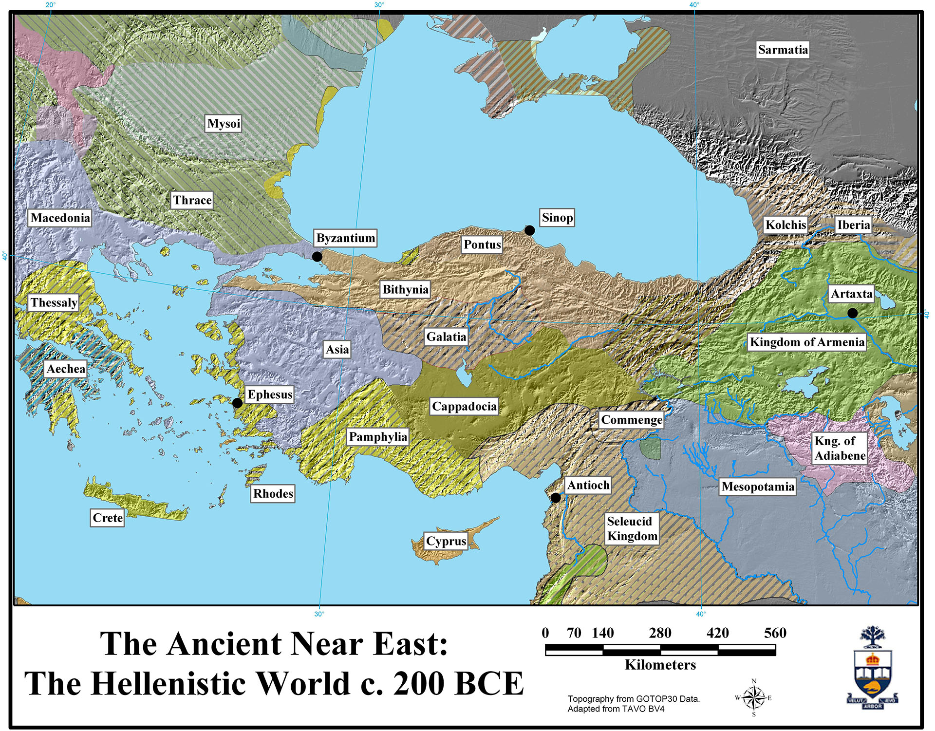
Map: Kingdoms and Regions of the Hellenistic Greece and Anatolia

Region: Aegean and Anatolia
Description:
Map of the various kingdoms and regions of the Hellenistic Aegean and Anatolia
Category: Maps
Type: Kingdom and Empire Maps
Period: Hellenistic
Date: 200 BCE
Credit: Stephen Batiuk, January 2005

Back to Browsing Maps[/vc_wp_text][/vc_column_inner][/vc_row_inner][mk_divider thickness=”1″ margin_top=”30″ margin_bottom=”30″][vc_row_inner][vc_column_inner css=”.vc_custom_1590517110399{padding-right: 20px !important;padding-bottom: 20px !important;}”][vc_widget_sidebar sidebar_id=”ca-sidebar-64142″][/vc_column_inner][/vc_row_inner][mk_divider thickness=”1″ margin_top=”30″][vc_widget_sidebar sidebar_id=”ca-sidebar-62968″][mk_padding_divider size=”20″][/vc_column][/vc_row][vc_row][vc_column][vc_column_text] [/vc_column_text][/vc_column][/vc_row]
Map: Kingdoms and Regions of the Hellenistic Ancient Near East – Near East (mid000004)

[vc_row fullwidth=”true” attached=”true” css=”.vc_custom_1590517688211{padding-top: 0px !important;padding-right: 0px !important;padding-bottom: 0px !important;padding-left: 0px !important;}”][vc_column][vc_single_image image=”61485″ img_size=”1920×600″ alignment=”center”][/vc_column][/vc_row][vc_row][vc_column][vc_column_text][/vc_column_text][/vc_column][/vc_row][vc_row fullwidth=”true” css=”.vc_custom_1490225468623{padding-top: 0px !important;padding-right: 0px !important;padding-bottom: 0px !important;padding-left: 0px !important;}”][vc_column width=”1/12″ css=”.vc_custom_1490225195470{margin-right: 10px !important;}” offset=”vc_hidden-sm vc_hidden-xs”][vc_column_text]

  SHARE

[/vc_column_text][mk_image src=”http://www.asortest.org/wp-content/uploads/2017/01/social-fb-icon4.jpg” image_width=”42″ image_height=”42″ hover=”false” custom_url=”https://www.facebook.com/ASOResearch/” margin_bottom=”0″][mk_image src=”http://www.asortest.org/wp-content/uploads/2017/01/social-tw-icon4.jpg” image_width=”42″ image_height=”42″ hover=”false” custom_url=”https://twitter.com/ASOResearch?ref_src=twsrc%5Egoogle%7Ctwcamp%5Eserp%7Ctwgr%5Eauthor” margin_bottom=”0″][mk_image src=”http://www.asortest.org/wp-content/uploads/2017/01/social-in-icon4.jpg” image_width=”42″ image_height=”42″ hover=”false” custom_url=”https://www.linkedin.com/company/american-schools-of-oriental-research” margin_bottom=”0″][mk_image src=”http://www.asortest.org/wp-content/uploads/2017/01/social-ml-icon_7.jpg” image_width=”42″ image_height=”42″ hover=”false” custom_url=”mailto:info@asor.org” margin_bottom=”0″][mk_image src=”http://www.asortest.org/wp-content/uploads/2017/01/blog-icon3.jpg” image_width=”42″ image_height=”42″ hover=”false” custom_url=”http://asor.org/blog” margin_bottom=”0″][/vc_column][vc_column border_color=”rgba(255,255,255,0.01)” width=”1/6″ css=”.vc_custom_1490365673198{margin-right: 20px !important;border-left-width: 2px !important;padding-right: 20px !important;padding-left: 20px !important;border-left-color: #99422f !important;}” el_class=”sticky-sidenav”][mk_divider divider_color=”rgba(255,255,255,0.01)” thickness=”1″ margin_top=”3″ margin_bottom=”3″][vc_widget_sidebar sidebar_id=”ca-sidebar-60550″ el_class=”.widget { overflow: hidden; margin-bottom: 0; }”][/vc_column][vc_column border_color=”rgba(170,170,170,0.01)” width=”8/12″ css=”.vc_custom_1490225606852{margin-right: 10px !important;margin-bottom: 30px !important;border-right-width: 2px !important;border-bottom-width: 2px !important;padding-top: 30px !important;padding-right: 30px !important;padding-left: 20px !important;background-color: #ffffff !important;border-right-color: rgba(227,228,228,0.75) !important;border-bottom-color: rgba(227,228,228,0.75) !important;}”][vc_row_inner][vc_column_inner width=”1/4″ css=”.vc_custom_1590517099925{margin-right: 20px !important;}”][vc_single_image image=”61117″ img_size=”full”][/vc_column_inner][vc_column_inner width=”3/4″][vc_wp_text]
ONLINE RESOURCES

ASOR Map Collections

[/vc_wp_text][/vc_column_inner][/vc_row_inner][mk_divider thickness=”1″ margin_top=”10″ margin_bottom=”10″][vc_row_inner][vc_column_inner width=”2/3″ css=”.vc_custom_1590550959746{padding-top: 30px !important;padding-right: 40px !important;}”][vc_single_image image=”69595″ img_size=”600 x 469″ onclick=”img_link_large” img_link_target=”_blank”][mk_padding_divider size=”10″][vc_wp_text]
Map ID: MID000004 – Download Image
[/vc_wp_text][/vc_column_inner][vc_column_inner width=”1/3″][vc_wp_text]

Map: Kingdoms and Regions of the Hellenistic Ancient Near East

Region: Aegean, Anatolia, Caucasus, Levant, Mesopotamia, Arabian Peninsula, Egypt
Description:
Map of the various kingdoms and regions of the Hellenistic Eastern Mediterranean
Category: Maps
Type: Kingdom and Empire Maps
Period: Hellenistic
Date: 200 BCE
Credit: Stephen Batiuk, January 2005

Back to Browsing Maps[/vc_wp_text][/vc_column_inner][/vc_row_inner][mk_divider thickness=”1″ margin_top=”30″ margin_bottom=”30″][vc_row_inner][vc_column_inner css=”.vc_custom_1590517110399{padding-right: 20px !important;padding-bottom: 20px !important;}”][vc_widget_sidebar sidebar_id=”ca-sidebar-64142″][/vc_column_inner][/vc_row_inner][mk_divider thickness=”1″ margin_top=”30″][vc_widget_sidebar sidebar_id=”ca-sidebar-62968″][mk_padding_divider size=”20″][/vc_column][/vc_row][vc_row][vc_column][vc_column_text] [/vc_column_text][/vc_column][/vc_row]

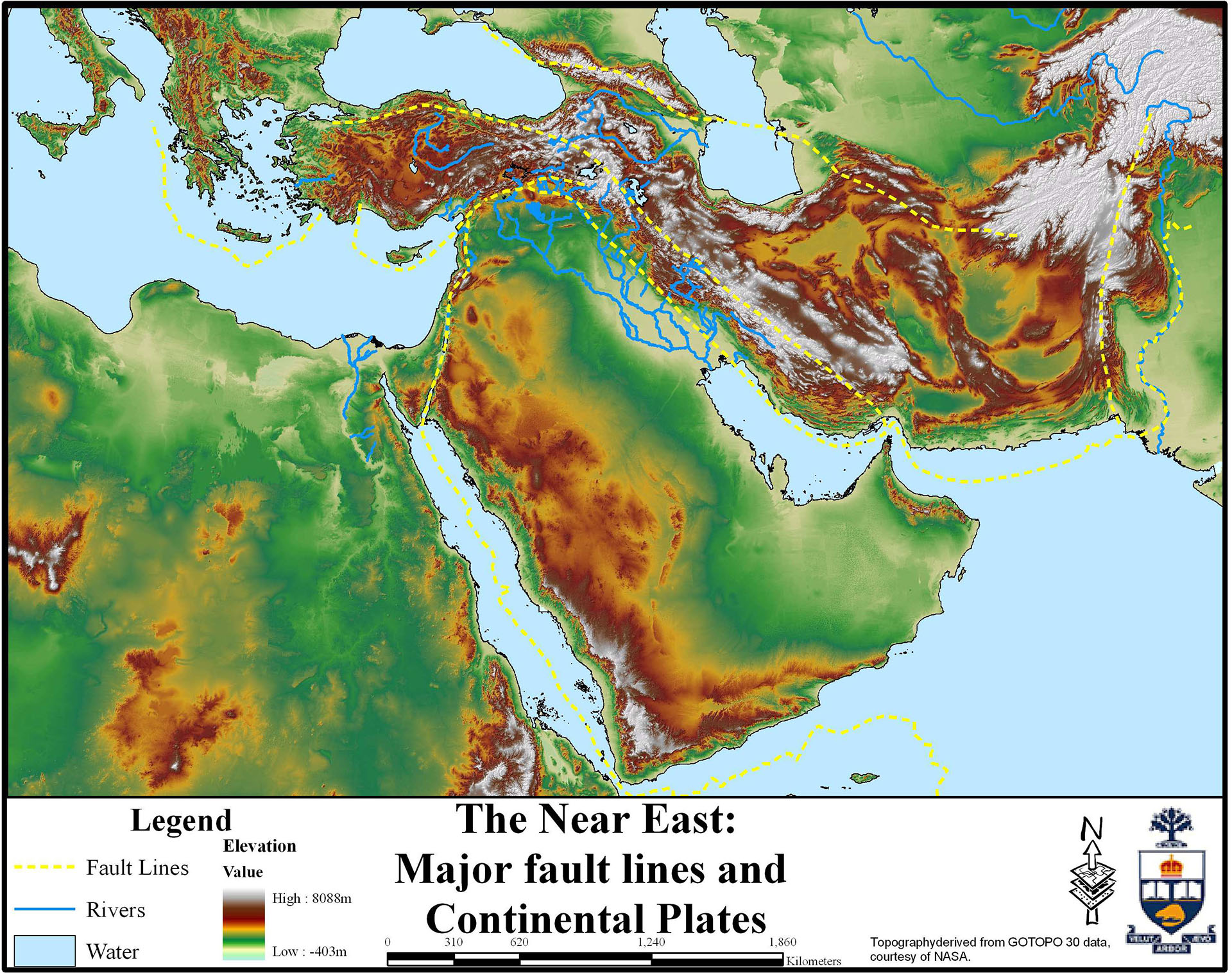
Map : Major Fault Lines in the Near East – Near East (mid000003)

[vc_row fullwidth=”true” attached=”true” css=”.vc_custom_1590517688211{padding-top: 0px !important;padding-right: 0px !important;padding-bottom: 0px !important;padding-left: 0px !important;}”][vc_column][vc_single_image image=”61485″ img_size=”1920×600″ alignment=”center”][/vc_column][/vc_row][vc_row][vc_column][vc_column_text][/vc_column_text][/vc_column][/vc_row][vc_row fullwidth=”true” css=”.vc_custom_1490225468623{padding-top: 0px !important;padding-right: 0px !important;padding-bottom: 0px !important;padding-left: 0px !important;}”][vc_column width=”1/12″ css=”.vc_custom_1490225195470{margin-right: 10px !important;}” offset=”vc_hidden-sm vc_hidden-xs”][vc_column_text]

  SHARE

[/vc_column_text][mk_image src=”http://www.asortest.org/wp-content/uploads/2017/01/social-fb-icon4.jpg” image_width=”42″ image_height=”42″ hover=”false” custom_url=”https://www.facebook.com/ASOResearch/” margin_bottom=”0″][mk_image src=”http://www.asortest.org/wp-content/uploads/2017/01/social-tw-icon4.jpg” image_width=”42″ image_height=”42″ hover=”false” custom_url=”https://twitter.com/ASOResearch?ref_src=twsrc%5Egoogle%7Ctwcamp%5Eserp%7Ctwgr%5Eauthor” margin_bottom=”0″][mk_image src=”http://www.asortest.org/wp-content/uploads/2017/01/social-in-icon4.jpg” image_width=”42″ image_height=”42″ hover=”false” custom_url=”https://www.linkedin.com/company/american-schools-of-oriental-research” margin_bottom=”0″][mk_image src=”http://www.asortest.org/wp-content/uploads/2017/01/social-ml-icon_7.jpg” image_width=”42″ image_height=”42″ hover=”false” custom_url=”mailto:info@asor.org” margin_bottom=”0″][mk_image src=”http://www.asortest.org/wp-content/uploads/2017/01/blog-icon3.jpg” image_width=”42″ image_height=”42″ hover=”false” custom_url=”http://asor.org/blog” margin_bottom=”0″][/vc_column][vc_column border_color=”rgba(255,255,255,0.01)” width=”1/6″ css=”.vc_custom_1490365673198{margin-right: 20px !important;border-left-width: 2px !important;padding-right: 20px !important;padding-left: 20px !important;border-left-color: #99422f !important;}” el_class=”sticky-sidenav”][mk_divider divider_color=”rgba(255,255,255,0.01)” thickness=”1″ margin_top=”3″ margin_bottom=”3″][vc_widget_sidebar sidebar_id=”ca-sidebar-60550″ el_class=”.widget { overflow: hidden; margin-bottom: 0; }”][/vc_column][vc_column border_color=”rgba(170,170,170,0.01)” width=”8/12″ css=”.vc_custom_1490225606852{margin-right: 10px !important;margin-bottom: 30px !important;border-right-width: 2px !important;border-bottom-width: 2px !important;padding-top: 30px !important;padding-right: 30px !important;padding-left: 20px !important;background-color: #ffffff !important;border-right-color: rgba(227,228,228,0.75) !important;border-bottom-color: rgba(227,228,228,0.75) !important;}”][vc_row_inner][vc_column_inner width=”1/4″ css=”.vc_custom_1590517099925{margin-right: 20px !important;}”][vc_single_image image=”61117″ img_size=”full”][/vc_column_inner][vc_column_inner width=”3/4″][vc_wp_text]
ONLINE RESOURCES

ASOR Map Collections

[/vc_wp_text][/vc_column_inner][/vc_row_inner][mk_divider thickness=”1″ margin_top=”10″ margin_bottom=”10″][vc_row_inner][vc_column_inner width=”2/3″ css=”.vc_custom_1590550959746{padding-top: 30px !important;padding-right: 40px !important;}”][vc_single_image image=”69592″ img_size=”600 x 474″ onclick=”img_link_large” img_link_target=”_blank”][mk_padding_divider size=”10″][vc_wp_text]
Map ID: MID000003 – Download Image
[/vc_wp_text][/vc_column_inner][vc_column_inner width=”1/3″][vc_wp_text]

Map: Major Fault Lines in the Near East

Region: Aegean, Anatolia, Caucasus, Levant, Mesopotamia, Arabian Peninsula, Egypt
Description:
Topographical map of the Eastern Mediterranean and the Near East with major fault lines noted with yellow dashed lines
Category: Maps
Type: Topographic Maps
Period: Modern
Date: 2005
Credit: Stephen Batiuk, September 2005

Back to Browsing Maps[/vc_wp_text][/vc_column_inner][/vc_row_inner][mk_divider thickness=”1″ margin_top=”30″ margin_bottom=”30″][vc_row_inner][vc_column_inner css=”.vc_custom_1590517110399{padding-right: 20px !important;padding-bottom: 20px !important;}”][vc_widget_sidebar sidebar_id=”ca-sidebar-64142″][/vc_column_inner][/vc_row_inner][mk_divider thickness=”1″ margin_top=”30″][vc_widget_sidebar sidebar_id=”ca-sidebar-62968″][mk_padding_divider size=”20″][/vc_column][/vc_row][vc_row][vc_column][vc_column_text] [/vc_column_text][/vc_column][/vc_row]
Map: Abasid Period Near East – Near East (mid000001)

[vc_row fullwidth=”true” attached=”true” css=”.vc_custom_1590517688211{padding-top: 0px !important;padding-right: 0px !important;padding-bottom: 0px !important;padding-left: 0px !important;}”][vc_column][vc_single_image image=”61485″ img_size=”1920×600″ alignment=”center”][/vc_column][/vc_row][vc_row][vc_column][vc_column_text][/vc_column_text][/vc_column][/vc_row][vc_row fullwidth=”true” css=”.vc_custom_1490225468623{padding-top: 0px !important;padding-right: 0px !important;padding-bottom: 0px !important;padding-left: 0px !important;}”][vc_column width=”1/12″ css=”.vc_custom_1490225195470{margin-right: 10px !important;}” offset=”vc_hidden-sm vc_hidden-xs”][vc_column_text]

  SHARE

[/vc_column_text][mk_image src=”http://www.asortest.org/wp-content/uploads/2017/01/social-fb-icon4.jpg” image_width=”42″ image_height=”42″ hover=”false” custom_url=”https://www.facebook.com/ASOResearch/” margin_bottom=”0″][mk_image src=”http://www.asortest.org/wp-content/uploads/2017/01/social-tw-icon4.jpg” image_width=”42″ image_height=”42″ hover=”false” custom_url=”https://twitter.com/ASOResearch?ref_src=twsrc%5Egoogle%7Ctwcamp%5Eserp%7Ctwgr%5Eauthor” margin_bottom=”0″][mk_image src=”http://www.asortest.org/wp-content/uploads/2017/01/social-in-icon4.jpg” image_width=”42″ image_height=”42″ hover=”false” custom_url=”https://www.linkedin.com/company/american-schools-of-oriental-research” margin_bottom=”0″][mk_image src=”http://www.asortest.org/wp-content/uploads/2017/01/social-ml-icon_7.jpg” image_width=”42″ image_height=”42″ hover=”false” custom_url=”mailto:info@asor.org” margin_bottom=”0″][mk_image src=”http://www.asortest.org/wp-content/uploads/2017/01/blog-icon3.jpg” image_width=”42″ image_height=”42″ hover=”false” custom_url=”http://asor.org/blog” margin_bottom=”0″][/vc_column][vc_column border_color=”rgba(255,255,255,0.01)” width=”1/6″ css=”.vc_custom_1490365673198{margin-right: 20px !important;border-left-width: 2px !important;padding-right: 20px !important;padding-left: 20px !important;border-left-color: #99422f !important;}” el_class=”sticky-sidenav”][mk_divider divider_color=”rgba(255,255,255,0.01)” thickness=”1″ margin_top=”3″ margin_bottom=”3″][vc_widget_sidebar sidebar_id=”ca-sidebar-60550″ el_class=”.widget { overflow: hidden; margin-bottom: 0; }”][/vc_column][vc_column border_color=”rgba(170,170,170,0.01)” width=”8/12″ css=”.vc_custom_1490225606852{margin-right: 10px !important;margin-bottom: 30px !important;border-right-width: 2px !important;border-bottom-width: 2px !important;padding-top: 30px !important;padding-right: 30px !important;padding-left: 20px !important;background-color: #ffffff !important;border-right-color: rgba(227,228,228,0.75) !important;border-bottom-color: rgba(227,228,228,0.75) !important;}”][vc_row_inner][vc_column_inner width=”1/4″ css=”.vc_custom_1590517099925{margin-right: 20px !important;}”][vc_single_image image=”61117″ img_size=”full”][/vc_column_inner][vc_column_inner width=”3/4″][vc_wp_text]
ONLINE RESOURCES

ASOR Map Collections

[/vc_wp_text][/vc_column_inner][/vc_row_inner][mk_divider thickness=”1″ margin_top=”10″ margin_bottom=”10″][vc_row_inner][vc_column_inner width=”2/3″ css=”.vc_custom_1590550959746{padding-top: 30px !important;padding-right: 40px !important;}”][vc_single_image image=”69585″ img_size=”600 x 477″ onclick=”img_link_large” img_link_target=”_blank”][mk_padding_divider size=”10″][vc_wp_text]
Map ID: MID000001 – Download Image
[/vc_wp_text][/vc_column_inner][vc_column_inner width=”1/3″][vc_wp_text]

Map: Abasid Period Near East

Region: Aegean, Anatolia, Caucasus, Levant, Mesopotamia, Arabian Peninsula, Egypt
Description:
Map of the extent of the Byzantine Empire and the Abasside Caliphate in the Eastern Mediterranean and Near East
Category: Maps
Type: Kingdom and Empire Maps
Period: Early Islamic / Byzantine
Date: 9th c CE
Credit: Stephen Batiuk, January 2005

Back to Browsing Maps

[/vc_wp_text][/vc_column_inner][/vc_row_inner][mk_divider thickness=”1″ margin_top=”30″ margin_bottom=”30″][vc_row_inner][vc_column_inner css=”.vc_custom_1590517110399{padding-right: 20px !important;padding-bottom: 20px !important;}”][vc_widget_sidebar sidebar_id=”ca-sidebar-64142″][/vc_column_inner][/vc_row_inner][mk_divider thickness=”1″ margin_top=”30″][vc_widget_sidebar sidebar_id=”ca-sidebar-62968″][mk_padding_divider size=”20″][/vc_column][/vc_row][vc_row][vc_column][vc_column_text] [/vc_column_text][/vc_column][/vc_row]
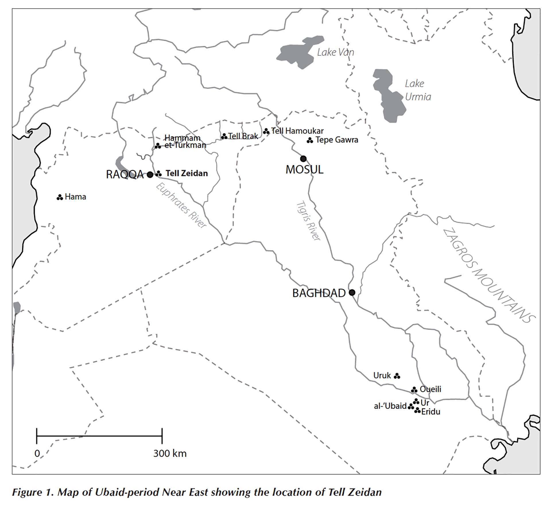
Map of Greater Mesopotamia and Tell Zeidan – Tell Zeidan, Syria (mid000040)

[vc_row fullwidth=”true” attached=”true” css=”.vc_custom_1590517688211{padding-top: 0px !important;padding-right: 0px !important;padding-bottom: 0px !important;padding-left: 0px !important;}”][vc_column][vc_single_image image=”72552″ img_size=”1920×600″ alignment=”center”][/vc_column][/vc_row][vc_row][vc_column][vc_column_text][/vc_column_text][/vc_column][/vc_row][vc_row fullwidth=”true” css=”.vc_custom_1490225468623{padding-top: 0px !important;padding-right: 0px !important;padding-bottom: 0px !important;padding-left: 0px !important;}”][vc_column width=”1/12″ css=”.vc_custom_1490225195470{margin-right: 10px !important;}” offset=”vc_hidden-sm vc_hidden-xs”][vc_column_text]

  SHARE

[/vc_column_text][mk_image src=”http://www.asortest.org/wp-content/uploads/2017/01/social-fb-icon4.jpg” image_width=”42″ image_height=”42″ hover=”false” custom_url=”https://www.facebook.com/ASOResearch/” margin_bottom=”0″][mk_image src=”http://www.asortest.org/wp-content/uploads/2017/01/social-tw-icon4.jpg” image_width=”42″ image_height=”42″ hover=”false” custom_url=”https://twitter.com/ASOResearch?ref_src=twsrc%5Egoogle%7Ctwcamp%5Eserp%7Ctwgr%5Eauthor” margin_bottom=”0″][mk_image src=”http://www.asortest.org/wp-content/uploads/2017/01/social-in-icon4.jpg” image_width=”42″ image_height=”42″ hover=”false” custom_url=”https://www.linkedin.com/company/american-schools-of-oriental-research” margin_bottom=”0″][mk_image src=”http://www.asortest.org/wp-content/uploads/2017/01/social-ml-icon_7.jpg” image_width=”42″ image_height=”42″ hover=”false” custom_url=”mailto:info@asor.org” margin_bottom=”0″][mk_image src=”http://www.asortest.org/wp-content/uploads/2017/01/blog-icon3.jpg” image_width=”42″ image_height=”42″ hover=”false” custom_url=”http://asor.org/blog” margin_bottom=”0″][/vc_column][vc_column border_color=”rgba(255,255,255,0.01)” width=”1/6″ css=”.vc_custom_1490365673198{margin-right: 20px !important;border-left-width: 2px !important;padding-right: 20px !important;padding-left: 20px !important;border-left-color: #99422f !important;}” el_class=”sticky-sidenav”][mk_divider divider_color=”rgba(255,255,255,0.01)” thickness=”1″ margin_top=”3″ margin_bottom=”3″][vc_widget_sidebar sidebar_id=”ca-sidebar-60550″ el_class=”.widget { overflow: hidden; margin-bottom: 0; }”][/vc_column][vc_column border_color=”rgba(170,170,170,0.01)” width=”8/12″ css=”.vc_custom_1490225606852{margin-right: 10px !important;margin-bottom: 30px !important;border-right-width: 2px !important;border-bottom-width: 2px !important;padding-top: 30px !important;padding-right: 30px !important;padding-left: 20px !important;background-color: #ffffff !important;border-right-color: rgba(227,228,228,0.75) !important;border-bottom-color: rgba(227,228,228,0.75) !important;}”][vc_row_inner][vc_column_inner width=”1/4″ css=”.vc_custom_1590517099925{margin-right: 20px !important;}”][vc_single_image image=”61117″ img_size=”full”][/vc_column_inner][vc_column_inner width=”3/4″][vc_wp_text]
ONLINE RESOURCES

ASOR Map Collections

[/vc_wp_text][/vc_column_inner][/vc_row_inner][mk_divider thickness=”1″ margin_top=”10″ margin_bottom=”10″][vc_row_inner][vc_column_inner width=”2/3″ css=”.vc_custom_1590550959746{padding-top: 30px !important;padding-right: 40px !important;}”][vc_single_image image=”69735″ img_size=”600 x 550″ onclick=”img_link_large” img_link_target=”_blank”][mk_padding_divider size=”10″][vc_wp_text]
Map ID: MID000040 – Download Image
[/vc_wp_text][/vc_column_inner][vc_column_inner width=”1/3″][vc_wp_text]

Tell Zeidan, Syria: Map of Greater Mesopotamia and Tell Zeidan

Country: Syria
Location: Tell Zeidan
Area:
Euphrates River Valley
Description: Map of Ubaid period Middle East showing location of Tell Zeidan
Category: Maps
Type: Site Maps
Period: Halaf – Ubaid LC1-2
Date: 6500 – 3800 BCE
Credit: Gil J. Stein, 2008

Back to Browsing Locations in Syria

Back to Browsing Maps[/vc_wp_text][/vc_column_inner][/vc_row_inner][mk_divider thickness=”1″ margin_top=”30″ margin_bottom=”30″][vc_row_inner][vc_column_inner css=”.vc_custom_1590517110399{padding-right: 20px !important;padding-bottom: 20px !important;}”][vc_widget_sidebar sidebar_id=”ca-sidebar-64142″][/vc_column_inner][/vc_row_inner][mk_divider thickness=”1″ margin_top=”30″][vc_widget_sidebar sidebar_id=”ca-sidebar-62968″][mk_padding_divider size=”20″][/vc_column][/vc_row][vc_row][vc_column][vc_column_text] [/vc_column_text][/vc_column][/vc_row]
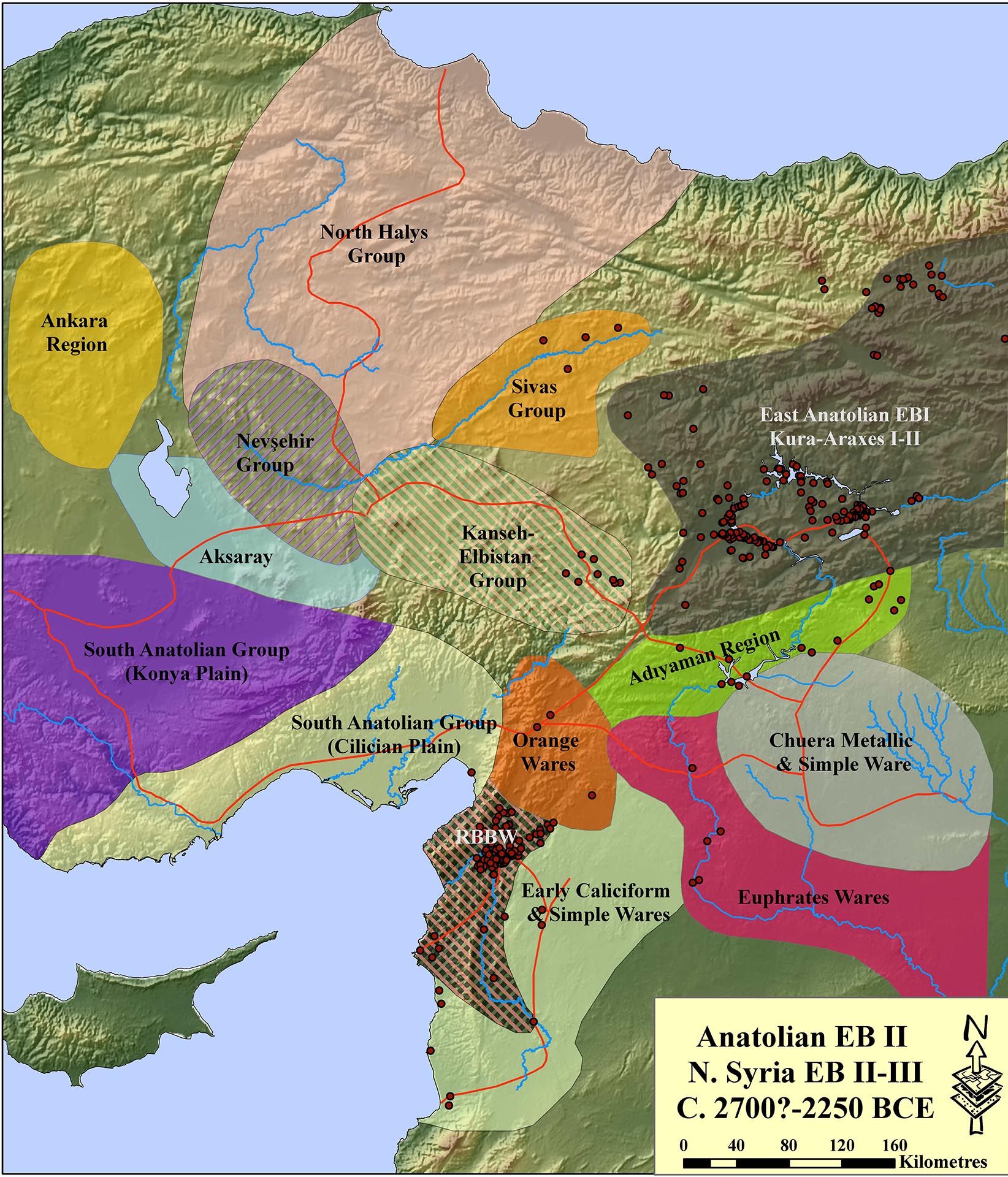
Map: Early Bronze Age II Anatolia – Anatolia (mid000002)

[vc_row fullwidth=”true” attached=”true” css=”.vc_custom_1590517688211{padding-top: 0px !important;padding-right: 0px !important;padding-bottom: 0px !important;padding-left: 0px !important;}”][vc_column][vc_single_image image=”61485″ img_size=”1920×600″ alignment=”center”][/vc_column][/vc_row][vc_row][vc_column][vc_column_text][/vc_column_text][/vc_column][/vc_row][vc_row fullwidth=”true” css=”.vc_custom_1490225468623{padding-top: 0px !important;padding-right: 0px !important;padding-bottom: 0px !important;padding-left: 0px !important;}”][vc_column width=”1/12″ css=”.vc_custom_1490225195470{margin-right: 10px !important;}” offset=”vc_hidden-sm vc_hidden-xs”][vc_column_text]

  SHARE

[/vc_column_text][mk_image src=”http://www.asortest.org/wp-content/uploads/2017/01/social-fb-icon4.jpg” image_width=”42″ image_height=”42″ hover=”false” custom_url=”https://www.facebook.com/ASOResearch/” margin_bottom=”0″][mk_image src=”http://www.asortest.org/wp-content/uploads/2017/01/social-tw-icon4.jpg” image_width=”42″ image_height=”42″ hover=”false” custom_url=”https://twitter.com/ASOResearch?ref_src=twsrc%5Egoogle%7Ctwcamp%5Eserp%7Ctwgr%5Eauthor” margin_bottom=”0″][mk_image src=”http://www.asortest.org/wp-content/uploads/2017/01/social-in-icon4.jpg” image_width=”42″ image_height=”42″ hover=”false” custom_url=”https://www.linkedin.com/company/american-schools-of-oriental-research” margin_bottom=”0″][mk_image src=”http://www.asortest.org/wp-content/uploads/2017/01/social-ml-icon_7.jpg” image_width=”42″ image_height=”42″ hover=”false” custom_url=”mailto:info@asor.org” margin_bottom=”0″][mk_image src=”http://www.asortest.org/wp-content/uploads/2017/01/blog-icon3.jpg” image_width=”42″ image_height=”42″ hover=”false” custom_url=”http://asor.org/blog” margin_bottom=”0″][/vc_column][vc_column border_color=”rgba(255,255,255,0.01)” width=”1/6″ css=”.vc_custom_1490365673198{margin-right: 20px !important;border-left-width: 2px !important;padding-right: 20px !important;padding-left: 20px !important;border-left-color: #99422f !important;}” el_class=”sticky-sidenav”][mk_divider divider_color=”rgba(255,255,255,0.01)” thickness=”1″ margin_top=”3″ margin_bottom=”3″][vc_widget_sidebar sidebar_id=”ca-sidebar-60550″ el_class=”.widget { overflow: hidden; margin-bottom: 0; }”][/vc_column][vc_column border_color=”rgba(170,170,170,0.01)” width=”8/12″ css=”.vc_custom_1490225606852{margin-right: 10px !important;margin-bottom: 30px !important;border-right-width: 2px !important;border-bottom-width: 2px !important;padding-top: 30px !important;padding-right: 30px !important;padding-left: 20px !important;background-color: #ffffff !important;border-right-color: rgba(227,228,228,0.75) !important;border-bottom-color: rgba(227,228,228,0.75) !important;}”][vc_row_inner][vc_column_inner width=”1/4″ css=”.vc_custom_1590517099925{margin-right: 20px !important;}”][vc_single_image image=”61117″ img_size=”full”][/vc_column_inner][vc_column_inner width=”3/4″][vc_wp_text]
ONLINE RESOURCES

ASOR Map Collections

[/vc_wp_text][/vc_column_inner][/vc_row_inner][mk_divider thickness=”1″ margin_top=”10″ margin_bottom=”10″][vc_row_inner][vc_column_inner width=”2/3″ css=”.vc_custom_1590550959746{padding-top: 30px !important;padding-right: 40px !important;}”][vc_single_image image=”69590″ img_size=”514 x 600″ onclick=”img_link_large” img_link_target=”_blank”][mk_padding_divider size=”10″][vc_wp_text]
Map ID: MID000002 – Download Image
[/vc_wp_text][/vc_column_inner][vc_column_inner width=”1/3″][vc_wp_text]

Map: Early Bronze Age II Anatolia

Region: Anatolia
Description:
Map of Early Bronze Age pottery types in Anatolia and Northern Syria with major archaeological sites noted
Category: Maps
Type: Ceramic Typology Maps
Period: Early Bronze Age II
Date: 2900 – 2600 BCE
Credit: Stephen Batiuk, January 2007

Back to Browsing Maps[/vc_wp_text][/vc_column_inner][/vc_row_inner][mk_divider thickness=”1″ margin_top=”30″ margin_bottom=”30″][vc_row_inner][vc_column_inner css=”.vc_custom_1590517110399{padding-right: 20px !important;padding-bottom: 20px !important;}”][vc_widget_sidebar sidebar_id=”ca-sidebar-64142″][/vc_column_inner][/vc_row_inner][mk_divider thickness=”1″ margin_top=”30″][vc_widget_sidebar sidebar_id=”ca-sidebar-62968″][mk_padding_divider size=”20″][/vc_column][/vc_row][vc_row][vc_column][vc_column_text] [/vc_column_text][/vc_column][/vc_row]

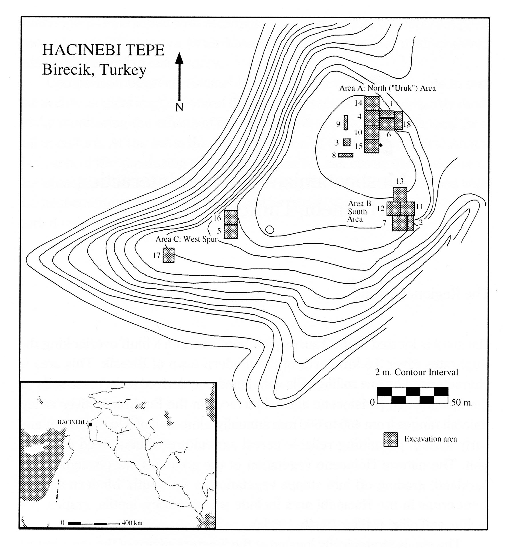
Site Topo Map – Hacinebi, Turkey (mid000042)

[vc_row fullwidth=”true” attached=”true” css=”.vc_custom_1590517688211{padding-top: 0px !important;padding-right: 0px !important;padding-bottom: 0px !important;padding-left: 0px !important;}”][vc_column][vc_single_image image=”72700″ img_size=”1920×600″ alignment=”center”][/vc_column][/vc_row][vc_row][vc_column][vc_column_text][/vc_column_text][/vc_column][/vc_row][vc_row fullwidth=”true” css=”.vc_custom_1490225468623{padding-top: 0px !important;padding-right: 0px !important;padding-bottom: 0px !important;padding-left: 0px !important;}”][vc_column width=”1/12″ css=”.vc_custom_1490225195470{margin-right: 10px !important;}” offset=”vc_hidden-sm vc_hidden-xs”][vc_column_text]

  SHARE

[/vc_column_text][mk_image src=”http://www.asortest.org/wp-content/uploads/2017/01/social-fb-icon4.jpg” image_width=”42″ image_height=”42″ hover=”false” custom_url=”https://www.facebook.com/ASOResearch/” margin_bottom=”0″][mk_image src=”http://www.asortest.org/wp-content/uploads/2017/01/social-tw-icon4.jpg” image_width=”42″ image_height=”42″ hover=”false” custom_url=”https://twitter.com/ASOResearch?ref_src=twsrc%5Egoogle%7Ctwcamp%5Eserp%7Ctwgr%5Eauthor” margin_bottom=”0″][mk_image src=”http://www.asortest.org/wp-content/uploads/2017/01/social-in-icon4.jpg” image_width=”42″ image_height=”42″ hover=”false” custom_url=”https://www.linkedin.com/company/american-schools-of-oriental-research” margin_bottom=”0″][mk_image src=”http://www.asortest.org/wp-content/uploads/2017/01/social-ml-icon_7.jpg” image_width=”42″ image_height=”42″ hover=”false” custom_url=”mailto:info@asor.org” margin_bottom=”0″][mk_image src=”http://www.asortest.org/wp-content/uploads/2017/01/blog-icon3.jpg” image_width=”42″ image_height=”42″ hover=”false” custom_url=”http://asor.org/blog” margin_bottom=”0″][/vc_column][vc_column border_color=”rgba(255,255,255,0.01)” width=”1/6″ css=”.vc_custom_1490365673198{margin-right: 20px !important;border-left-width: 2px !important;padding-right: 20px !important;padding-left: 20px !important;border-left-color: #99422f !important;}” el_class=”sticky-sidenav”][mk_divider divider_color=”rgba(255,255,255,0.01)” thickness=”1″ margin_top=”3″ margin_bottom=”3″][vc_widget_sidebar sidebar_id=”ca-sidebar-60550″ el_class=”.widget { overflow: hidden; margin-bottom: 0; }”][/vc_column][vc_column border_color=”rgba(170,170,170,0.01)” width=”8/12″ css=”.vc_custom_1490225606852{margin-right: 10px !important;margin-bottom: 30px !important;border-right-width: 2px !important;border-bottom-width: 2px !important;padding-top: 30px !important;padding-right: 30px !important;padding-left: 20px !important;background-color: #ffffff !important;border-right-color: rgba(227,228,228,0.75) !important;border-bottom-color: rgba(227,228,228,0.75) !important;}”][vc_row_inner][vc_column_inner width=”1/4″ css=”.vc_custom_1590517099925{margin-right: 20px !important;}”][vc_single_image image=”61117″ img_size=”full”][/vc_column_inner][vc_column_inner width=”3/4″][vc_wp_text]
ONLINE RESOURCES

ASOR Map Collections

[/vc_wp_text][/vc_column_inner][/vc_row_inner][mk_divider thickness=”1″ margin_top=”10″ margin_bottom=”10″][vc_row_inner][vc_column_inner width=”2/3″ css=”.vc_custom_1590550959746{padding-top: 30px !important;padding-right: 40px !important;}”][vc_single_image image=”69741″ img_size=”554 x 600″ onclick=”img_link_large” img_link_target=”_blank”][mk_padding_divider size=”10″][vc_wp_text]
Map ID: MID000042 – Download Image
[/vc_wp_text][/vc_column_inner][vc_column_inner width=”1/3″][vc_wp_text]

Hacinebi, Turkey: Site Topographic Map

Country: Turkey
Location: Hacinebi
Description:
Hacinebi – topographic map showing excavation areas
Category: Maps, Archaeological Site
Type: Topographic Maps
Period:
 Chalcolithic, Early Bronze Age, Persian
Date: 5500 – 2000 BCE , 550 – 330 BCE
Credit: Gil J. Stein, 2005

Back to Browsing Locations in Turkey

Back to Browsing Maps[/vc_wp_text][/vc_column_inner][/vc_row_inner][mk_divider thickness=”1″ margin_top=”30″ margin_bottom=”30″][vc_row_inner][vc_column_inner css=”.vc_custom_1590517110399{padding-right: 20px !important;padding-bottom: 20px !important;}”][vc_widget_sidebar sidebar_id=”ca-sidebar-64142″][/vc_column_inner][/vc_row_inner][mk_divider thickness=”1″ margin_top=”30″][vc_widget_sidebar sidebar_id=”ca-sidebar-62968″][mk_padding_divider size=”20″][/vc_column][/vc_row][vc_row][vc_column][vc_column_text] [/vc_column_text][/vc_column][/vc_row][mk_page_section][vc_column][/vc_column][/mk_page_section]