


2018 POSTER ABSTRACTS
Posters are listed alphabetically by the presenter’s last name.
CHAIR: Jennifer Ramsay (The College at Brockport, State University of New York)
- Sereen Al Shoubaki (Independent Scholar), “New Mathematical and Artistic Approaches to the Understanding of the Mosaic Floor Design in the Crypt of Saint Elianus”
Mosaic art can be categorized into different motifs such as inscriptions and images of plants, people, and animals. But mosaic art also depends on geometry. This poster intends to clarify the designs of mosaic motifs in the Crypt of Saint Elianus, located in Madaba in central Jordan. It will feature artistic elements of the mosaic, showing a new geometrical analysis of the floor decoration.
Geometry is concerned with the division of spaces into systematic areas. The design of this floor was based upon repeating the octagon that resulted from drawing the circles, and connecting the circles within each other to produce an integrated and symmetrical form. This arrangement of the basics of geometry rules results in unique, complete, and symmetrical proportion.
When we study the division of the circles and the pattern, we can understand the meaning of the golden ratio, 1.618. This is the connection between mathematics and art, but in geometry it is formed by using the principle of intersection between two circles, producing many ratios. This floor was built with two main ratios and with 6×2 squares. The octagons form two adjacent rows, but the main rectangle is divided into six duplicate squares, each square having a complete octagonal shape and a quarter circle on each corner; when we put the six squares next to each other we obtain the original form.
These analyses can help in studying the octagons geometrical pattern and comparing them with each other, and also in redrawing and restoration.
- Georgia Andreou (Brown University) and Edoardo Neerhut (Mapillary), “Monitoring Archaeological Sites with the Use of Crowdsourced Data: Mapillary and the Cyprus Ancient Shoreline Project”
Coastal erosion of archaeological sites has long been a problem for archaeologists seeking to understand maritime interactions in the past. A new model, using crowdsourced geographical information relating to modern processes of erosion along the southern coast of Cyprus, is showcased here, with the hope that it can be expanded and adapted for use elsewhere to incorporate local communities in the monitoring and protection of vulnerable archaeological sites.
This sustainable methodological approach actively uses information derived from local knowledge (archaeological finds recorded by the public). Crowdsourced data are collected via Field Papers—an application that combines user-friendly analogue maps with customized barcodes used for georeferencing and visualization in Open Street Maps. It also uses Mapillary, a street-level imagery platform that extracts map data. These data can be compared diachronically to highlight sites and parts thereof that experience the highest rates of coastal erosion.
- Jeremy Beller (University of Victoria), Haskel J. Greenfield (University of Manitoba), and Aren M. Maeir (Bar-Ilan University) , “Stones in Homes: The Spatial Distribution and Use of Ground Stone Objects at EB III Tell es-Safi/Gath, Israel”
The distribution and context of artifacts are important for understanding activity areas and the organization and use of space within households. A large ground stone assemblage has been recovered from the EB III (ca. 2900–2500 B.C.E.) settlement of Tell es-Safi/Gath, Israel. These artifacts occur in a variety of types, materials, and conditions within the residential neighborhood that has been exposed in Area E of the site. Specifically, ground stone objects were primarily found in the courtyards, alleyway, and as part of the construction of walls, floors, and installations. These data indicate that food production and other tasks occurred in the central courtyard of each house and that, after the initial life expenditure of the ground stone objects, the residents deliberately discarded them in the alleyway or extensively utilized them for secondary purposes. As such, this behavior reflects aspects of necessary daily subsistence and the construction of domestic structures within an early urban settlement.
- Vanessa Boschloos (Metropolitan Museum of Art; Ghent University), Guy Bunnens (Univeristy of Liège), François de Callataÿ (Université libre de Bruxelles), Roald Docter (Ghent University), and Eric Gubel (Royal Museums of Art and History; Vrije Universiteit Brussel), “Phoenician and Punic Antiquities in Belgium”
The Corpus of Phoenician and Punic Antiquities (CAPP) is an international initiative adopted by the International Union of Academies aiming to virtually bring together Phoenician and Punic material culture, spread across countries around the Mediterranean in antiquity but now also found in museum collections worldwide. The objective of the project is to list, classify, and study Phoenician and Punic artistic and epigraphical monuments in association with the most important museums, local collections, and excavations. It builds up a coherent body of documentation, published as the work proceeds, for the benefit of specialists and the general public alike. The CAPP network constitutes today of several national committees. This poster presents the activities and results to date of the Belgian chapter.
- Annie Brown (University of Manitoba), Sarah Richardson (University of Manitoba), Haskel J. Greenfield (University of Manitoba), and Aren M. Maeir (Bar-Ilan University), “Spatial Representation of Heavy Fraction Collection and Analysis from Tell es-Safi/Gath, Israel”
Most modern excavations intensively collect data from flotation, including both light and heavy fractions. While the light fraction (floated) is usually extensively analzsed by archaeobotanists, the heavy fraction (or micro-residue) is often ignored or minimally examined since it requires intensive efforts at the microscopic level to recover and identify the remains. When heavy fraction is collected systematically across floors within a house or building, the analysis allows for the identification of different activities that are often less visible with macroscopic remains. The importance of heavy fraction is further supported through spatial analysis, which allow activity areas to be visually represented and analyzed.
This poster will present the preliminary spatial analysis of the heavy fraction from the excavations of the EB III non-elite residential neighborhood excavated at Tell es-Safi/Gath, a site located in central Israel overlooking the coastal plain. By spatially representing the results of the heavy fraction we will broaden our understanding of early urban lifeways among the urban non-elite.
- Zuzana Chovanec (Institute of Archaeology, Slovak Academy of Sciences), “‘What the Heck is Noscapine?’ and Other Questions: A Guide for Interpreting Residue Study Literature for Archaeologists”

Organic residue analysis (ORA) studies in Near Eastern archaeology have become increasingly more common. This type of analysis is frequently conducted by specialists outside of the field of archaeology or archaeologists who have variable levels of training in the physical sciences. Following a workshop on organic residue analysis at the 2017 Annual Meeting, a point was raised that having some guidelines for evaluating the analytical results that they provide would be useful for archaeologists who are not well versed in the interpretative nuances of ORA. This poster aims to address this need by clarifying the analytical process, the way in which data are interpreted, and some suggestions for better evaluating the relevance of analytical data to archaeological questions.
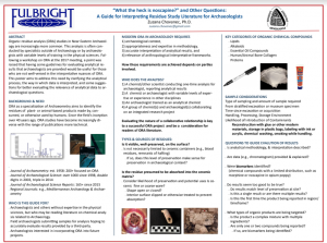
- Mikayla Coad (University of Saskatchewan) and Michael Lewis (University of Saskatchewan; Texas A&M University), “The Use of New Technologies to Present Pottery Sherds in Museum Settings”

3D printing in a museum setting allows for the creation of physical replicas of otherwise inaccessible objects. At the University of Saskatchewan, a deeper connection was made with museum visitors by making use of this new technology to bring virtual creations into physical form.
The digital reconstruction of ceramic artifacts was produced using a 3D laser scanner to scan individual sherds, which were then used as a reference to digitally recreate the artefact with Autodesk’s Fusion 360 2018. Once the complete pottery vessel was digitally reconstructed, the location of the original sherd was cut from the model and the resulting vessel was 3D printed. The original sherd was then joined with the 3D printed vessel to provide visitors with a complete understanding of the artifact that the sherd originated from. The 3D models were also incorporated into an interactive display using Intuilab’s Intuiface version 6.1.7 that allowed museum visitors to interact with and manipulate the models. The process of recreating ancient vessels digitally and physically allowed for a comprehensive display of the ceramics represented in a fragmentary collection.
The visitor experience was greatly enhanced through the use of 3D printing, 3D pottery reconstruction, and the interactive digital display. Using new technologies provided visitors with knowledge of complex topics in an easy to understand manner and promoted education for minimal capital expenditure. In this way, computer applications in archaeology can transcend from a digital to a physical realm.
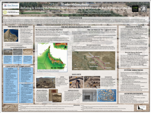
- Eli Dollarhide (New York University), “Prehistoric Pointillism: Rock Art in the Omani Interior”
Petroglyphs are among the most ubiquitous archaeological features in southeastern Arabia, yet they remain one of the most poorly understood aspects of the region’s prehistory. Re-occurring motifs of people, weapons, camels, horses, and other animal figures appear in similar forms across the UAE and Oman, and many were produced utilizing similar methods. Though they offer a unique gateway into the symbolic worlds of Arabia’s ancient inhabitants, the study of Arabian rock art is complicated by issues of dating and documentation.
This poster explores the recent discovery of over 200 petroglyphs in the Omani interior. Documented during the Mapping Magan survey, as part of the larger Bat Archaeology Project, these examples of ancient art are spread over five wadis located near the modern settlement of ‘Amlah, Oman. The various images were impressed on limestone with percussion, in a fashion resembling a prehistoric form of pointillism. Although interpreting these complex and temporally-dynamic features remains difficult, the proximity of these petroglyphs to a nearby Iron Age cemetery offers new insight into their meaning and connections to other rock art sites in the region. The research concludes by examining new strategies for preserving this open-air site.
- Jennie Ebeling (University of Evansville), Erez Adama (University of Haifa), and Danny Rosenberg (University of Haifa), “Detecting the Artisans’ Fingerprints in the Workshop: A Technological Approach to Basalt Vessel Manufacture in the Iron Age Workshop at Tel Hazor, Israel”
Basalt vessels are one of the most common ground stone artifact types known in the Iron Age southern Levant. They are found in a variety of contexts and reflect different types and morphologies as well as a high level of craftsmanship. The artisans who produced these elaborate, symmetrical, and finely-finished vessels required great skill and technological know-how in order to reduce the risk of failure, especially during the latter stages of vessel production. The discovery of a basalt vessel workshop at Tel Hazor, the largest biblical-era site in Israel, offers a rare opportunity to delve into frequently hidden aspects of basalt vessel technology, including their production sequence (chaîne opératoire) and discard patterns, as the pre-finishing stages of stone vessel manufacture cannot usually be detected. The current project, conducted in the Laboratory for Ground Stone Tools Research in the Zinman Institute of Archaeology, University of Haifa, focuses on a high-resolution typo-technological study of the basalt vessel preforms (vessels discarded during their production) found mainly within a ninth–eighth century B.C.E. basalt vessel workshop at Tel Hazor, as well as other preforms found in various strata and contexts at the site.
- Debra Foran (Wilfrid Laurier University), Stanley Klassen (University of Toronto), Věra Doležálková (Charles University), Gregory Braun (University of Toronto), and David Lipovitch (Wilfrid Laurier University), “Buried Cooking Pots: Late Hellenistic Ritual Practices at Khirbat al-Mukhayyat”
The Town of Nebo Archaeological Project (TNAP) was established to investigate Khirbat al-Mukhayyat’s sacred landscape and its role in ritual activity during different time periods. The first three excavation seasons have revealed numerous Hellenistic (second-first century B.C.E.) artifacts and features, including over 60 complete or nearly complete cooking pots. These vessels were all found sitting upright in a series of superimposed layers not associated with any structures and they appear to have been intentionally buried. The cooking pots fall into five basic forms based on rim and neck typology. Preliminary macroscopic analysis has identified between five and seven fabric groups. This work is part of the ongoing petrographic analyses of the Khirbat al-Mukhayyat ceramics to identify correlations between form and fabric, potting traditions during the Hellenistic period, and the potential provenience of these vessels. Preliminary residue analysis indicates that sherds from these vessels contain significant amounts of lipids. The analysis of these lipid signatures suggests that these vessels were used to cook animal products. Further analysis will allow us to identify what specific animal products were being cooked in these pots.
Given the lack of any associated architecture or evidence for domestic activity, coupled with the singular nature of this collection, these deposits of cooking pots must be the result of a local religious or cultural tradition, possibly associated with ritual feasting. The exact nature of this activity remains unclear; however, it is a testament to the importance and continuity of the sacred nature of Mukhayyat’s landscape.
- John Green (American Center of Oriental Research), Glenn Corbett (Council for American Overseas Research Centers), and Eman Abdesalaam (American Center of Oriental Research), “Temple of the Winged Lions Cultural Resources Management (TWLCRM) Initiative, Petra”
The Temple of the Winged Lions (TWL) is an important temple of Petra, Jordan. It was built overlooking the ancient city center in the first century A.D., likely to honor the Nabataean goddess Al Uzza. The temple was so-named because of the capitals on the top of the columns surrounding the podium (platform) inside the temple, which were carved in the shape of winged lions. The American Expedition to Petra (AEP), directed by the late Philip Hammond, excavated the site between 1974 and 2005. The excavations exposed many areas of the temple over the course of these many field seasons, yielding important archaeological information about TWL. By the end of the AEP excavations, however, the site was in significant need of conservation. In 2009 the American Center of Oriental Research (ACOR), the Department of Antiquities of Jordan (DOA), and the Petra Development and Tourism Region Authority (PDTRA) launched the Temple of the Winged Lions Cultural Resource Management (TWLCRM) Initiative. The project has sought to fully document, conserve, preserve, and present this monument to visitors. The work, conducted to high international conservation and documentation standards, has been a collaborative effort between organizations, authorities, conservators and technicians, and local communities. In collaboration with ACOR, and with support from the USAID-SCHEP project, the TWLCRM sustainable model has played an important role in enhancing the local capacity of surrounding local communities through training, raising educational awareness, and delivery of hands-on experiences for school children and tourists alike. This poster presents the key achievements of the initiative through text, images, and graphics.
- Tina L. Greenfield (University of Saskatchewan), Itzick Shai (Ariel University), Chris McKinny (Texas A&M University-Corpus Christi), Jane Gaastra (University College London), and Andrea Orendi (University of Tübingen), “Understanding Late Bronze Canaanite Cultic Space: Tel Burna, Israel”
Area B1 at Tel Burna, Israel consists of a single occupational layer—the 13th century B.C.E. This layer, the largest expanse at Tel Burna, sits just below and to the west of the rise of the site’s Iron Age fortifications. After seven seasons of excavation, we suggest that Area B1 primarily consists of a large enclosure with a distinctive cultic courtyard directly atop the bedrock. On this surface, a high concentration of cult-related items were discovered, including imported pithoi, votive and zoomorphic vessels from Cyprus, ceramic masks, what appears to be standing stones, figurines, goblets, and chalices; a large array of bioarchaeological material (both animal and plant) was also uncovered in the spaces surrounding the cultic space (Shai, Uziel, and McKinny 2015; Greenfield, McKinny, and Shai 2017; Shai et al. in press). In order to properly assess and define what a cultic space represents during this time period, it is necessary to look activity areas within the rooms and courtyard that make up this structure. This poster presents a graphically illustrated spatial distribution of the artifactual material found in Area B1. The integrative nature of this analysis visually demonstrates the distribution of each unique set of data in order to better understand the spatial relationship between ritual behavior and the associated artifacts within a Late Bronze Age sacred space.
- Geoffrey Hedges-Knyrim (University of Connecticut) and Alexia Smith (University of Connecticut), “Evidence of Middle Bronze Age Subsistence at Tell Qarqur, Syria: The Macrobotanical Evidence”
The multi-period site of Tell Qarqur is located in the lower Orontes River Valley in northwestern Syria. Evidence of Middle Bronze Age occupation at the site is limited compared to occupations in the preceding Early Bronze Age and the later Iron Age and Classical period. Previous research has shown the relatively equal importance of both legumes and cereals during the EB IV (including finds of a catastrophically preserved bitter vetch deposit) and increased reliance on cereals alongside the diminished presence of legumes in the Iron Age. Middle Bronze Age archaeobotanical samples from the 2009 excavation season were preserved by mundane charring and were mostly found in area D on the northern mound. Samples show evidence of mixed cultivation of wheat, barley, grape, and legumes (including chickpea and common pea) along with remains of wild grasses such as Lolium sp. (ryegrass) and Phalaris sp. Although preliminary, data from Middle Bronze Age Tell Qarqur provides information on subsistence in this period in the lower Orontes Valley of western Syria.
- Blair Heidkamp (University of Cincinnati), “Assessing Changes in Spindle Whorl Assemblages from the Pottery Neolithic, Chalcolithic, and Early Bronze Age I in the Southern Levant”
Spindle whorls, flywheels attached to a shaft used for the production of thread, are one of the only artifacts related to the textile industry that survives in the archaeological record. Spindle whorls, therefore, are often the only line of evidence available to make inferences about the prehistoric textile industry. At the crossroads between Anatolia, Mesopotamia, and Egypt, the southern Levant is at the intersection of cultural and technological change, particularly during the chronological scope of my study: the Pottery Neolithic, Chalcolithic, and EB I periods. There has yet to be a comprehensive study of spindle whorl assemblages covering the entirety of the southern Levant over multiple chronological periods. As a part of my master’s thesis, I collected data from published sources to create a database of whorls. I noticed specific trends in the data, most notably a shift from primarily ceramic whorls in Pottery Neolithic assemblages to a majority of EB I whorls made of stone. By evaluating the observed trends in the data in combination with known aspects of the materials and process of spinning, I was able to draw conclusions about changes in the textile industry during these periods in the southern Levant.
- Ashley Himmelstein (University of Haifa), Assaf Yasur-Landau (University of Haifa), and Michael Lazar (Harvard University), “Frequency Domain Electromagnetic Surveys of Dor’s South Bay”
This project conducted a frequency domain electromagnetic (FDEM) survey of Dor’s South Bay to find evidence of both buried harbor features and a navigational passage. A previous FDEM survey of this area had been conducted by Lazar et al., testing the viability of FDEM surveys in a coastal environment by focusing on two sections of the coastline. The results of this previous study suggested the possible presence of buried man-made objects, along with proving that FDEM surveys are viable in coastal environments. This new project has expanded the previous survey into one continuous FDEM survey along the coast and across the tombolo which separates the bay and the lagoon. Both the previous and the new FDEM surveys were conducted using a Gem-2 FDEM device, and the data were processed in Oasis Montaj. The expanded FDEM survey revealed several areas of interest, including a series of features along the edge of the coastline which have been identified as Features 1, 2, 3, and 4. While none of these features match what was observed in the previous survey, this patterned line of anomalous areas which appear similar to each other indicate possible buried man-made features. Furthermore, two areas in the southern portion of the survey, referred to as Area A and Area B, show evidence of the buried passage between the Tantura Lagoon and Dor’s South Bay, along with evidence of possible harbor structures near this passage. These results have been further supported by the recent discovery of artifacts in the water nearby, along with evidence from Area B present in both surveys. This research has revealed the possible locations of harbor features in Dor’s South Bay while also finding the past passage into the bay, which justifies further research focused on the southern end of the bay.
- Jake Hubbert (Brigham Young University), “Nabataean Course Ware Pottery Dating System”
The coarse ware pottery created by the ancient Nabataeans of Petra is unique and among the most understudied pottery types from the Hellenistic and Roman eras in the Near East. This poster is about my research in developing an updated typology of this pottery. The organization is based on comparative shapes, sizes, and other physical attributes, as well as stratigraphic find sites, in order to organize these wares into a chronological dating system. The majority of analyzed samples came from the Ad-Deir Plateau, especially Eastern Cistern B. The research challenge presented by my study encompasses the fact that many of the Nabataean coarse or common wares are both underrepresented and understudied by many previous archaeological excavations. The critical importance of the Ad-Deir Plateau, and specifically this cistern, is that we have a wealth of Nabataean pottery deposited in a sealed context from which we can gain an even deeper understanding and refinement of the present dating systems proposed by Schimd (2007) and Khairy (1975). This research will lead to new perspectives concerning site dating and artifact classification from Petra and surrounding Nabatean sites in the Levant and Arabia.
- Benjamin Irvine (British Institute at Ankara), “A Proposed ‘Subsistence Package’ for the Early Bronze Age of the Greater Near East”
In this poster a preliminary proposal is presented for a “subsistence package” in the Early Bronze Age of Anatolia and adjacent regions. This proposal follows from investigating the dietary habits of several prehistoric (specifically, ca. 3500–2000 B.C.) populations from different environmental regions of Anatolia, including: İkiztepe (northern Anatolia), Titriş Höyük (southeastern Anatolia), Bademağacı (southern Anatolia), and Bakla Tepe (southwestern Anatolia). While there has been substantial research into the dietary habits and subsistence practices of early sedentary agricultural populations in Anatolia and in later historical periods, the fourth and third millennia B.C. have been overlooked. Instead, research in these periods has focused primarily on material culture, where artifacts are studied individually, largely detached from their surrounding environment and social, cultural, technological, and economic contexts.
Analysis of carbon and nitrogen stable isotopes (δ13C and δ15N) was employed on bone collagen from ca. 200 human and faunal osteological samples and analysis of sulphur isotopes (δ34S) was employed on bone collagen from ca. 50 human and faunal osteological samples (of the original ca. 200). These primary data have been evaluated in conjunction with previously published data including isotopic, archaeobotanical, and archaeozoological data from the Early to Middle Bronze Age greater Near East. The conclusions of this analysis suggest that there was a narrowing in the range of arable agriculture, from a diverse range of plants in the Late Neolithic and Chalcolithic periods to a monotonous and specialized range of cultivated plants in the Early Bronze Age. Furthermore, livestock management also became a specialized and intensive endeavor.
- Morag Kersel (DePaul University), Marly Prom (DePaul University), and ANT256 Students (DePaul University), “Where Are They Now? Following Pots into Archives, Educational Institutions, and Museum Vitrines”

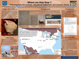
Systematic excavations in the 1960s at the Early Bronze Age (ca. 3600–2000 B.C.E.) site of Bab adh-Dhra‘ on the Dead Sea Plain in Jordan recovered thousands of ceramic pots from various tombs, all requiring basic conservation and storage. There was not enough storage space in Jordan for the thousands of pots, so in 1977 the Jordanian Department of Antiquities and the American Schools of Oriental Research (the excavation sponsors) came up with a scheme to distribute artifact tomb groups to educational institutions for purposes of study, display, and student-based learning. DePaul University students of ANT 256—Old World Material Culture tracked 13 of the original 24 tomb groups to their current North American locations. In the spring/summer of 2018, with an ASOR Study Collection Fellowship, Kersel tracked additional tomb groups. Archival records of the transactions, museum visits, and ethnographic interviews provide a fascinating glimpse into the unusual dispersal of this corpus of material. This poster will answer the “Where are they now?” question and gauge the efficacy and feasibility of the ASOR Ad Hoc Tomb Distribution project as a future potential solution to the on-going curation crisis facing archaeological collections throughout the eastern Mediterranean and Middle East.
- Jennifer Markowitz (University of Central Florida) and Tiffany Earley-Spadoni (University of Central Florida), “Welcome to Karaglux: One Project’s Journey into Social Media and Public Archaeology (Vayots Dzor, Armenia)”
In the summer of 2018, the Vayots Dzor Fortress Landscapes Project completed a season of field work and survey. An important component of our public history agenda was the continuation of a digital storytelling and social media push that was initiated in 2017. One desirable albeit unexpected outcome of our research model was that it created instant dialog with the stakeholders in the community. By geotagging our photographs and posting them to our public Facebook and Instagram accounts, the residents of nearby villages learned of our research and began to visit the site in person to learn more. Our excavation work was even featured on local fan sites hosted on Facebook. While we were initially concerned that the increased visibility of our site via social media might make it more susceptible to vandalism, we observed that this was not the case. To the contrary, we noticed that our work towards publicizing our research efforts resulted in appreciation from the community on their own social media and we had no problems with destruction. We conclude that the described digital storytelling and social media as public archaeology strategies could be effectively employed by other projects working in the region.
- Samuel Martin (University of Arkansas), Dominique Langis-Barsetti (University of Toronto), Joseph Lehner (University of Sydney), Emre Kuruçayırlı (Boğaziçi University), Asu Selen Özcan (Institute of Nautical Archaeology), and Nicolle Hirschfeld (Trinity University), “Volumetric Analysis of the Cape Gelidonya Shipwreck Copper Ingot Cargo”
The 1960 excavation of the Late Bronze Age shipwreck at Cape Gelidonya, on the southwestern coast of modern Turkey, represents one of the first applications of terrestrial archaeological methods to systematically analyze underwater remains. Continuing the history of applying novel methods to the Cape Gelidonya shipwreck, 200 copper ingots from the ship’s cargo were sampled and scanned using photogrammetry and structured light scanning. The ingots represent the bulk of the preserved cargo and were specifically shaped for transport. The process by which the ingots were created, deposited, and corroded left each with a unique topographic surface. The complex and porous nature of the ingots has made assessments of their true volume impossible to evaluate through standard methods such as displacement. Using a combination of microscopy and measurements taken from 3D models of the ingots, we can identify more detailed typologies among the copper cargo. Metallographic analysis was used to account for the porosity of individual ingots while scanning was used to calculate the volumes using computer programs, in particular, Agisoft PhotoScan Pro, Artec Studio 12, and MeshLab. Photogrammetry and structured light scanning also serve as a relatively low-cost method for creating archival data for the analysis of objects that are not physically or easily accessible. Finally, 3D models were used to investigate finer surface details such as makers’ marks or tool marks. This analysis hopes to answer broader questions about the origin, acquisition, and destination of the Bronze Age cargo.
- Erika Morey (University of Arkansas), “Don’t Eat Dates! What Dental Pathology Can Tell Us about Food Consumption at Tell el-Amarna”
Sixty years ago it was hypothesized that wind-blown sand in bread had a large impact on dental wear and antemortem tooth loss in ancient Egypt. While dental anthropologists have increasingly taken a more nuanced view of the interplay between dental wear and tooth loss in the intervening years, few are revisiting the topic of food consumption and dietary sources of dental pathology. The current study investigates the relationship between dental pathology and food consumption at Tell el-Amarna in order to reconstruct the contributions of specific foodstuffs to an individual’s diet in this ancient capital city. Utilizing the individuals of the South Tombs Cemetery (n=432) as our study population, there is ample evidence to suggest that wind-blown sand and environmental grit were not a major contributing factor to dental pathology. The prevalence of dental caries in the population, on the other hand, suggests that the diet was high in cariogenic (causing tooth decay) foods such as dates, doûm palm fruit, and others high in fermentable carbohydrates (sugars).
- Massimiliano Nuzzolo (Charles University) and Andrea D’Andrea (L’Orientale University of Naples), “Reconstructing ancient monuments: from scans to ABIM. The study-case of the Sun Temple of Niuserra, Egypt”
Since 2010 an Italian archaeological mission has conducted new investigations in the sun temple of Niuserra at Abu Ghurab (Egypt). This investigation is aimed at reconsidering and reassessing all the data available on the monument which, after its discovery in 1898, had never been archaeologically re-analyzed. The final goal of the work is to make an updated plan of the temple complex as well as a new 3D virtual reconstruction.
More than 100 scans have been carried out in the past 3 campaigns with the aim to recreate the general architecture of the temple. At the same time, 3D models of some specific parts of the temple have been produced by means of digital photogrammetry. In order to interconnect all the acquired 3D and 2D datasets, a BIM (Building Information Modelling) project has been developed. Thanks to this new methodological approach, currently underdeveloped in archaeology, it is now possible not only to analyze the whole architecture of the temple but also to produce categories of environmental and technological objects (the so-called “libraries”) which represent the 3D semantic of the model.
This poster deals with all the recent achievements of the mission, in particular the conceptualization of the architectural model of the temple, the new interpretations of the monument deriving from it, and the future research perspectives in terms of data management and understanding.
- Tiffany Okaluk (University of Manitoba), Haskel J. Greenfield (University of Manitoba), Tina L. Greenfield (University of Saskatchewan), Aren M. Maeir (Bar-Ilan University), and Aslıhan Yener (ISAW, New York University), “Urban vs. Rural Butchery Practices in the Early Bronze Age: A Comparison of Butchering Technology between Tell es-Safi/Gath, Israel, and Göltepe, Turkey”
The analysis of butchery practices from archaeological sites can offer unique insights into past cultural identity and socio-economic organization of communities through differences and similarities in diet, technology, and tool use. This poster compares the butchery/cut-mark analysis from two Early Bronze Age (3500/3000–2500/2000 B.C.E.) sites from widely separated regions to determine if there are such differences: 1) an urban, domestic neighborhood of Tell es-Safi/Gath, an early city located in the southeastern Shephelah (now Israel); and 2) Göltepe, a tin mining and metal production village located on the south-central Anatolian plateau. The Early Bronze Age was a formative period for urbanism in the Levant and Anatolia, while also a period of technological innovation, such as the experimentation with and production of metal alloys.
Standardized microscopic cut-mark analysis allows for reliable identification of blade raw material (stone vs. metal; Greenfield 1999), while the distribution of butchering patterns may identify technological variation in the butchering tool kit that could relate to group identity. Preliminary comparison of blade material found that the rural metal production site and the urban site show no significant difference in raw material or in butchering patterns.
- Malkia Okech (University of Pennsylvania), “Fantasy and Reality: Experiments with VR in Archaeological Reconstruction”
One of the goals of archaeology is to reconstruct the past, but how do we do so? The field has made great strides in employing digital technologies to visualize data. The incorporation of 3D models can take archaeological surveying to the next level by creating an immersive outlet to explore the reconstruction of past landscapes and architecture. Virtual reality potentially furthers this immersion, allowing us to better reconstruct the past. My project aims to explore how to best incorporate numerous subjective and traditional objective variables in 3D reconstructions. In the digital realm, the lines between fantasy and reality are blurred and this project seeks to leave room for archaeological analysis in a digital space and discover if this method of visualization improves or detracts from our conclusions.
Data from the University of Pennsylvania’s survey in Armenia, in collaboration with the Vayots Dzor Fortress Landscapes Project (VDFLP) of the University of Central Florida, serve as a case study for exploring the utility of immersive digital reconstruction. UAV (Unmanned Aerial Vehicle) photos taken from a possible fort site and run through Agisoft Photoscan provide our initial 3D reconstruction that will be refined through interpreting and analyzing the existing comparative data. Is a photorealistic model a good creative choice or are interpretations better left more stylized and exaggerated? Viewing these attempts through a head-mounted display, such as Oculus Rift or HTC Vive, will offer analytical possibilities in a close to real-world scale, and allow us to explore the utility of the technology.
- Brandon Olson (Metropolitan State University of Denver), Tom Landvatter (Reed College), Justin Stephens (Metropolitan State University of Denver), and Scott Moore (Indiana University of Pennsylvania), “Pyla-Koutsopetria 2018 Field Season”
This poster looks at the Pyla-Koutsopetria Archaeological Project (PKAP). It will outline how the 2018 season relates to earlier projects at the site that will be published in the forthcoming Pyla-Koutsopetria II. The team did not find, as anticipated, the monumental fortification wall discovered in 2012. Rather, the small sounding excavation of 2018 revealed an impressive in situ mud brick wall constructed on top of a large cut stone wall, situated on bedrock. At the base of the wall we discovered a small, purposefully constructed chamber. The chamber contained pottery fragments and faunal material, possibly the remains of a foundation deposit from the construction of the wall. This discovery substantiates the chronology of the Vigla settlement from earlier excavations. It also indicates that there was more monumental construction at the Vigla settlement than previously believed. Future PKAP work planned for Vigla will attempt to clarify the size and complexity of this Hellenistic fortification and to examine the role it played in the history of the region.
- Atlan Pimprenelle (University of Haifa; Université Paris 1-Panthéon Sorbonne), “Social, Political, and Economic Aspects of the Monumental Fortifications in the Eastern Mediterranean Coast and Mesopotamia (ca. 2000–1450 B.C.)”
This research attempts to show the social, economic, and political connections that existed in monumental fortifications constructed during the EB IV to LB I periods in Mesopotamia and the Levant. It follows the work of Burke (2008) and Rey (2012) using a larger dataset as well as a set of criteria that enables intra- and inter-regional comparison. For this purpose, the study selected 84 sites from Mesopotamia and the Levant. All the data were analyzed using architectural and diachronic methods, and two databases were created. The architecture was divided by specific types of structures (fortifications, gates, fortresses, bastions, and towers). These areas were divided and organized by time periods from 2400 to 1450 B.C. In addition, we noted the period of use, abandonment, or destruction of different structures.
The first results showed uninterrupted usage of the sites from northern Mesopotamia and the northern Levant from EB III to EB IVA. Some sites are known to have been abandoned in the EB IV. Some sites flourished during the MB I to the MB II. In contrast, there were no fortified sites during the EB IV in the southern Levant. Some fortified sites appeared there during the MB I. However, most of the fortified sites existed during the transitional period MB II-III. During MB III the fortified sites increased in number.
Finally, some conclusions will be offered connecting fortified sites to region-specific social, economic and political conditions.
- Lucas Proctor (University of Connecticut), “Exploring Fuel Use Variability in Late Chalcolithic Households at Surezha, Iraqi Kurdistan”
The burning of fuel resources for heating and lighting homes, preparing food and craft goods, and eliminating waste is an essential daily domestic practice on par with the acquisition of food and shelter in satisfying basic subsistence needs. With the emergence of complex societies, ever greater resources would have been necessary to fuel economic production and support growing populations in towns and cities. Households would have been under increasing pressure to adequately provision their hearths on a daily basis, balancing scarcity due to localized deforestation, competition with neighbors, and emerging administrative control of resources with socially conditioned preferences or functional requirements for what constitutes appropriate fuels and transport cost.
The site of Surezha, located 20 km south of the modern city of Erbil, is a 22 ha conical mound with well-stratified deposits dating to the Chalcolithic Period, ca. 5300 to 3100 B.C., when the first urban societies began to emerge in Mesopotamia. Excavations have been conducted by the Oriental Institute since 2013 in order to investigate the emergence of social complexity and the origins of towns and later cities. This poster presents the results of a combined archaeobotanical, anthracological, and geoarchaeological analysis of two multiphase houses at Surezha, illustrating the kinds of fuel remains present within the hearths and refuse deposits of the structures, and the spatial distribution of fuel remains between houses and/or between different deposits. The results of this analysis suggest mixed fuel use across the site, with dung fuel and crop processing debris preferred within household hearths, while woody taxa were recovered from a large circular pyrotechnic feature in the west house. Wood fuel may therefore have been reserved for specialized craft production activities, while dung was used primarily for cooking and heating.
- Sarah Richardson (University of Manitoba), Tina L. Greenfield (University of Saskatchewan), Haskel J. Greenfield (University of Manitoba), and Aren M. Maier (Bar-Ilan University), “Who? What? Where? Understanding the Population, Their Household Organization, and Activities through Bone Tool Use at Tell es-Safi/Gath, Israel”
The site of Tell es-Safi/Gath’s Early Bronze Age neighborhood (Area E) has been intensively digitally recorded using GIS since 2012. This integrative digital approach has provided the opportunity for detailed spatial analysis by locus and artifact basket, allowing for minute changes in the spatial distribution of material remains to be mapped and analyzed.
Tool use in antiquity has been used as a metric for better understanding ancient behavior since the beginning of activity analysis. The corpus of tools found in the EB III phase of Tell es-Safi/Gath’s Area E include those made of flint, bone, and ground stone. A preliminary look at the bone tool corpus is spatially presented here to provide insights into the intensity of bone tool use and the distinct types of activities between and within individual houses associated with these data. The integration of spatial and artifactual data provides us with a broader view and understanding of the behavior and activities associated with the inhabitants at the Early Bronze Age non-elite neighborhood of Tell es-Safi/Gath.
- Katherine Rose (Harvard University) and Sara Zaia (Harvard University), “3D Methods in Ceramic Analysis: Technology and Production of Predynastic Egyptian and Nubian Ceramics”
In the early 20th century, seminal Egyptologist George Reisner excavated a series of predynastic cemeteries west of the Giza plateau and farther south in modern day Sudan. While some objects from specific cemeteries were published in original manuscripts, the majority of artifacts currently housed in Harvard University’s Peabody Museum remain unstudied. Through a combination of ceramic analyses, we aim to elucidate the relationship between Predynastic Egypt and Nubia in terms of ceramic production and technology in mortuary contexts. We present a systematic study of ceramic material from selected cemeteries at sites such as Keneh, Mesaeed, and Kerma, combined with 3D scanning of complete vessels and ceramic sherds. Over the last two decades, applications of 3D recording and visualization have provided opportunities to study a wide array of archaeological materials, objects, and cultural heritage, such as architecture, monuments, manuscripts, and pottery. When applied to ceramics, 3D scanning contributes to sophisticated forms of documentation such as the rendering of accurate profiles for classification and reconstruction. We apply 3D scanning methods to collect data regarding the surface geometry, texture, volume, shape, and other technological aspects of vessels and sherds in order to understand patterns in ceramic manufacturing processes, methods, and strategies among Predynastic Nile Valley cultures. Our objective is to contribute to the study of pan-African interconnectivity between Egypt and Nubia more broadly, through the multi-faceted study of the ceramic material from a funerary context.
- Joanna S. Smith (University of Pennsylvania), “Cypriot Art at the Ringling Museum: A New Gallery”

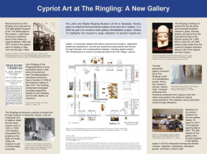
The John and Mable Ringling Museum of Art in Sarasota, Florida plans to install its first permanent gallery of ancient art in Gallery 12 in 2020 as part of a museum-wide gallery reinstallation project. Gallery 12 highlights the museum’s large collection of ancient Cypriot art. John Ringling (of The Ringling Brothers Circus) acquired nearly all works of ancient art now at the Ringling during four days of auction at the Anderson Gallery in 1928. All of these pieces were once part of the Metropolitan Museum of Art’s collections in New York. At 3500 objects, the ancient collection today is the museum’s largest holding; 2300 of those objects were unearthed by Luigi Palma di Cesnola on Cyprus between 1865 and 1876. Gallery 12 will connect viewers through thematic and contextualized displays with the history of ancient Cyprus and the history of the collection, Cypriot aesthetics especially as understood through approaches to detail and abstraction, and art and experience through sanctuaries and tombs. The centerpiece of the gallery is a crowd of limestone sculptures said to be from Golgoi, Cyprus. The objects, themes, and design of the gallery make links with the new Asian wing of the museum as well as the museum’s collections of European and Contemporary art and the museum’s miniature circus. Preparation of the 200 pieces for the initial installation is now underway by this author together with colleagues at the Ringling Museum. This poster summarizes the history of the collection and previews the new gallery.
- Berk Suleyman (Hunter College), “An Expedition to the Sacred Landscapes of the Valley: AVRP 2018 Highland Survey”
Situated in Hatay, the southernmost province of Turkey, the Amuq Valley represents a rich archaeological landscape that is especially important in Mesopotamian and Anatolian archaeology, due to long-standing systematic excavations that provide invaluable insight into chronological sequences of the region. The Amuq Valley’s location, a node between Mesopotamia and the Mediterranean, Anatolia, and the Levant, gives a glimpse of this diverse political, social, economic, and geographic landscape.
The 2018 season of the Amuq Valley Regional Projects field survey focused on sacred highland spaces located on the eastern and western fringes of the valley. To the east of the valley, near the modern village of Akpınar, a rocky outcrop referred to as Kızılkaya was investigated, which revealed dolmens, cromlechs, and Roman rock tombs. To the west of the valley in the Amanus mountains, close to the modern Ceylanlı village, the recent discovery of a Neo-Babylonian rock relief led the survey team to concentrate on its surrounding landscape, thus investigating the symbolic/functional placement of the relief. These point towards the durable prominence of sacred landscapes in the surrounding highlands of the Amuq over the longue dureé.
Recent ongoing research contributes to the understanding of the dynamic relations between the highlands and lowlands of the Amuq Valley. The cost-efficient and practical utilization of drones for high-resolution photography, and the 3D photogrammetric rendering of those images, improves our understanding of the vast highland landscapes that were investigated and documented, providing a special insight on sacred areas, monumentality, and prominence spanning from the Late Chalcolithic to the late Iron Age in the surrounding landscape of the Amuq Valley.
- Laura Swantek (Arizona State University), “Reconfiguring Social Networks: The Emergence of Social Complexity before and after Urbanism on Cyprus”
Despite the lack of cities, the Prehistoric Bronze Age on Cyprus (ca. 2400–1700 cal B.C.) witnesses high wealth inequality and the emergence of social complexity. Previous research has shown that social complexity emerges and disappears as underlying social networks are reconfigured through changing economic and social connections at different moments and in different communities during the Prehistoric Bronze Age. Is cycling in the emergence of social complexity a phenomenon only present in middle-range or pre-urban society? This poster explores the underlying social and economic networks of the Prehistoric Bronze Age and Protohistoric Bronze Age (ca. 1700–1200 cal B.C.) on Cyprus using mortuary data, through time and across space. Quantitative methods derived from complex adaptive systems, small world network analysis, and modern economics are used to compare the emergence of social complexity and measure wealth inequality on either side of the urbanism divide.
- Jennifer Swerida (University of Pennsylvania), Charlotte Cable (University of New England), and Christopher Thornton (University of Pennsylvania), “Shades of Complexity: Defining and Linking the Umm an-Nar Monuments and Settlement at Bat, Sultanate of Oman”
“Complexity” is a seemingly essential descriptor in studies of ancient civilizations. Early polities are celebrated for their complex systems of social organization, of cultural symbols and beliefs, of economic exchange and production, and of writing or administration. While state-level societies are widely recognized as the high-water mark of sociopolitical and economic complexity, recent work recognizes that complex non-state societies have developed elaborate internal organizational systems and have played significant roles in interactions with other complex societies. The Umm an-Nar civilization (ca. 2700–2000 B.C.E.) of southeastern Arabia is one such case study of the complex non-state. Without developing state-level institutions or urban centers, the Umm an-Nar people constructed monumental architecture, supported specialized craft production, and traded with states and non-states throughout the greater ancient Near East. Yet, attempts to understand Umm an-Nar complexity have been hindered by studies that isolate either monuments or settlements, but fail to include both in their larger context.
This poster introduces the newest phase of the Bat Archaeological Project, which aims to produce, for the first time, a coherent picture of an Umm an-Nar site and its society. The UNESCO World Heritage Site of Bat includes an extensive and well-preserved concentration of Umm an-Nar monuments and settlements. This project will use archival research, pedestrian survey, and excavation to identify spatial organization, trends in material culture, architectural variation, and land use. These will proxy for the study of complex sociopolitical organization and complex systems of exchange and production in an inland Umm an-Nar settlement.
- Julia Troche (Missouri State University), “Sacred Grooves in Ancient Egypt”
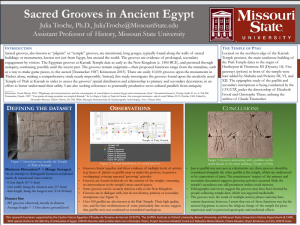
Sacred grooves, also known as “pilgrim” or “temple” grooves, are intentional, long gouges, typically found along the walls of sacred buildings or monuments. The grooves are evidence of secondary engagement by visitors. Though the grooves’ function(s) remain elusive, some scholars have hypothesized that the dust collected by gouging a sacred wall may have had apotropaic or medicinal uses (e.g. Daumas 1972; Traunecker 1987), while others have argued the marks were the result of mundane arrowhead sharpening (e.g. Fehn 1909). This poster will summarize my findings based on fieldwork at the Temple of Ptah at Karnak, and will complicate our understanding of these sacred grooves. As part of the Karnak Graffiti Project (directed by Elizabeth Frood, under the auspices of the Centre Franco-Égyptien d’Étude des Temples de Karnak [CFEETK]), I observed almost 300 grooves along the exterior walls of the Temple of Ptah at Karnak. The temple, which was in use from approximately the 15th century B.C.E. to the 2nd century C.E., is modest in size and almost entirely preserved, making it a good candidate for a case study. This poster summarizes my initial analysis of the orientation of these grooves and seeks cross-cultural parallels to better understand this enigmatic phenomenon.
- Candise Vogel (University of California, Los Angeles), “Satrapy, Sedition, and Sacralization: A Historiographic Analysis of Egyptian Society under Imperial Rule and Its Lessons for the Future”

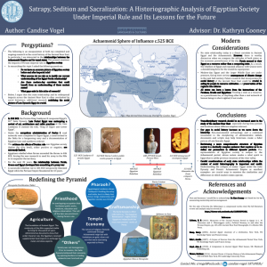
This poster presents an historiographic analysis of existing source material and holistic scholarly works that contribute to the current understanding of Egyptian society during the Achaemenid Empire, approximately 525–332 B.C.E. Here I propose new methodologies for the study of culture in regard to kingship and hierarchy in Egypt. The poster will summarize a litany of case studies that analyze the Late Dynastic period, including works relating to narrative sources, material culture, papyri, and administrative communications between the Egypt and Persia. While Egypt was already in a state of intermediary power when it submitted to the Persian Empire, its status as a vassal state of the Achaemenids forever changed how Egyptian society interpreted and managed religion, art, trade, and war. Likewise, Egypt’s resistance and continued attempts to subvert its captor would contribute to the decline and ultimate demise of the Achaemenid Empire. Through the combination of Egyptological and Persian/ancient Near Eastern sources, I will explore these relationships at the dawn of statehood and their impact on society, and discuss the implications for the emerging state super-powers of today and tomorrow.
- Heleen Wilbrink (Aincient), “Cleo, an Online Museum without Boundaries: Searching over 30,000 Ancient Egyptian Objects from Multiple International Collections by Text, Image, and Location on cleo.aincient.org”
Many museum collections and other resources on ancient Egypt have been digitized over the last few decades, but they are not yet used to their full potential. There are several barriers: digital collections are not standardized; they are not available in a common language; and they are not connected. They are isolated silos.
For this reason, Cleo was created: an online museum tool connecting four major international museum collections, supplemented through the use of artificial intelligence (AI). Cleo combines over 30,000 objects from the National Museum of Antiquities, the Brooklyn Museum, the Metropolitan Museum of Art, and the Walters Art Museum. The collections are standardized using Thot thesauri and are automatically translated into English and Dutch. In addition to text search and filtering, image search—which is where the AI comes in—is available for finding related objects. The goals are to add many more collections and other kinds of sources, make Cleo available in several languages, and refine the image search.
Cleo is created by social enterprise Aincient, whose mission is to unlock ancient cultures using cutting-edge technology. Our focus lies on ancient Egypt, since the founder of Aincient, Heleen Wilbrink, is an Egyptologist. The development of Cleo has generously been made possible by the SIDN Fund and the Google Cloud Startup Program, and we are grateful to the four museum collections, and to Leiden University and many others for continuous feedback.
- Victoria Wilson (University of Chicago), “Cult of the Deceased Entu: The Ur III Giparu at Ur”
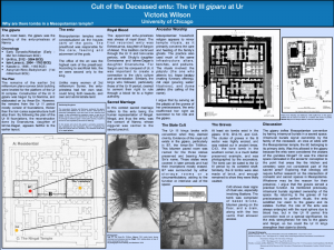
Among the cultic buildings within Ur’s sacred precinct stood the giparu. The giparu served as the dwelling of the entu-priestess of Nanna and the temple of the goddess Ningal, consort of Nanna. The entu was to be the divine representation of Ningal on earth. The giparu went through several building phases from the third to first millennia B.C.E. This analysis will focus on the Ur III structure, the earliest of the recognizable remains. The plan of the Ur III structure contained at least three sanctuaries, an intramural “cemetery,” and one isolated tomb. These intramural burials defy Mesopotamian convention, which excluded graves from temples. The presence of the burials will thus be viewed as though part of a residence, with the analysis drawing from concepts in household religion. The entu would have served as the pāquidu, “the one who attends to,” for the ghosts of the deceased entu—making funerary offerings and libations at their tombs.
The kings of the Ur III dynasty made claims to divinity. Furthermore, the Ur III kings retained the Akkadian tradition of appointing their daughters as entu-priestesses. By analyzing the delineation and functions of the giparu’s interior space, in particular the tombs, the complex religious and political role of the living entu will be examined. As the entu strengthened her right to the giparu through the rites of ancestor worship, so too did the Ur III kings strengthen their claims to divinity through their earthly relation to the entu.