SHARE
[/vc_column_text][mk_image src=”http://www.asortest.org/wp-content/uploads/2017/01/social-fb-icon4.jpg” image_width=”42″ image_height=”42″ hover=”false” custom_url=”https://www.facebook.com/ASOResearch/” margin_bottom=”0″][mk_image src=”http://www.asortest.org/wp-content/uploads/2017/01/social-tw-icon4.jpg” image_width=”42″ image_height=”42″ hover=”false” custom_url=”https://twitter.com/ASOResearch?ref_src=twsrc%5Egoogle%7Ctwcamp%5Eserp%7Ctwgr%5Eauthor” margin_bottom=”0″][mk_image src=”http://www.asortest.org/wp-content/uploads/2017/01/social-in-icon4.jpg” image_width=”42″ image_height=”42″ hover=”false” custom_url=”https://www.linkedin.com/company/american-schools-of-oriental-research” margin_bottom=”0″][mk_image src=”http://www.asortest.org/wp-content/uploads/2017/01/social-ml-icon_7.jpg” image_width=”42″ image_height=”42″ hover=”false” custom_url=”mailto:asor@bu.edu” margin_bottom=”0″][mk_image src=”http://www.asortest.org/wp-content/uploads/2017/01/blog-icon3.jpg” image_width=”42″ image_height=”42″ hover=”false” custom_url=”http://asorblog.org/” margin_bottom=”0″][/vc_column][vc_column border_color=”rgba(255,255,255,0.01)” width=”1/6″ css=”.vc_custom_1493004112151{margin-right: 20px !important;border-left-width: 2px !important;padding-right: 20px !important;padding-left: 20px !important;border-left-color: #99422f !important;}”][mk_divider divider_color=”rgba(255,255,255,0.01)” thickness=”1″ margin_top=”3″ margin_bottom=”3″][vc_widget_sidebar sidebar_id=”sidebar-16″ el_class=”.widget { overflow: hidden; margin-bottom: 0; }”][/vc_column][vc_column border_color=”rgba(170,170,170,0.01)” width=”8/12″ css=”.vc_custom_1487276122024{margin-right: 10px !important;margin-bottom: 30px !important;border-right-width: 2px !important;border-bottom-width: 2px !important;padding-top: 30px !important;padding-right: 30px !important;padding-left: 20px !important;background-color: #ffffff !important;border-right-color: rgba(227,228,228,0.75) !important;border-bottom-color: rgba(227,228,228,0.75) !important;}”][vc_row_inner][vc_column_inner width=”1/3″ css=”.vc_custom_1515089047502{padding-right: 20px !important;}”][mk_image src=”https://www.asor.org/wp-content/uploads/2017/12/foa-reduced-100.png” image_width=”190″ image_height=”100″ crop=”false” hover=”false”][/vc_column_inner][vc_column_inner width=”2/3″][vc_column_text responsive_align=”left”]December 2016
Vol. 4, No. 12
[/vc_column_text][/vc_column_inner][/vc_row_inner][mk_divider thickness=”1″ margin_top=”10″][vc_row_inner][vc_column_inner][vc_column_text responsive_align=”left”]Antioch on the Orontes 2.0. New Stories from an Ancient City
By Andrea U. De Giorgi
Constantine the Great’s elevation of a hitherto unassuming city on the Bosphorus to the highest imperial rank in the fourth century CE altered the course of history in fundamental ways. It also accelerated the process of Rome’s eastward tilting that had put Antioch on the Orontes center stage for more than two centuries.[/vc_column_text][/vc_column_inner][/vc_row_inner][vc_row_inner][vc_column_inner][vc_single_image image=”41606″ img_size=”full” add_caption=”yes” alignment=”center”][vc_single_image image=”41607″ img_size=”full” add_caption=”yes” alignment=”center”][/vc_column_inner][/vc_row_inner][vc_column_text responsive_align=”left”]Laid out as a heady fusion of Mesopotamian and Hellenistic designs by Seleukos Nikator in 302 BCE, Antioch straddled a vast and challenging landscape that had witnessed millennia of human occupation. In the founder’s mind, the city was to be but one of the many colonies that secured North Syria in Seleucid hands, perhaps modeled after the grand capital Seleucia on the Tigris, inaugurated only a few years earlier. Antioch’s setting, however, could not have been more unpromising; the vexations caused by seasonal runoff from Mt. Silpius and Mt. Staurin, in tandem with the course fluctuations of the Orontes, took a hefty toll from the very onset. Nor was being located on an active seismic belt of better auspice, for during the course of history Antioch suffered from a staggering sequence of earthquakes.
Nevertheless, within a few generations after its foundation, Antioch began a rise to political prominence that was to last for centuries, marked by a string of political designations and titles. In the classical, Byzantine and Islamic sources we encounter Antioch successively as Seleucid capital, Roman provincial capital, virtual capital of the Roman orient, host to a vibrant intellectual community and the earliest Christian congregation, seat of a Patriarch and the count of the east, and hub of the Islamic thughūr, to name but its few accomplishments.
More subtly, though, Antioch’s growth brought a shift in the way space in antiquity was perceived and experienced. By sewing together Mesopotamia and the Mediterranean, the city forged a new Greco-Roman oikoumene (inhabited world), one that gradually swung its fulcrum away from the Italian peninsula. Roads led to Antioch from Egypt, Mesopotamia, and Asia; Byzantine chroniclers narrated the whole history of the world from the banks of the Orontes.
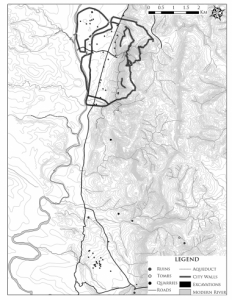
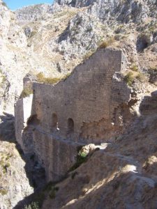
For all the fame of the city and its once magnificent architecture, however, the physical fabric of ancient and early medieval Antioch is still poorly documented. This is in part due to recent urbanization of the area. Antioch’s modern reincarnation Antakya (Hatay province, southeast Turkey) grows by the day at the expense of its ancient predecessor. The city walls, hippodrome, and temple on the island are the last witnesses of Antioch’s heyday. What is more, the archaeological exploration of the relatively undisturbed site of Antioch in the 1930s, unfortunately, produced modest results. In the intervening years, it seemed that the goal of a coherent understanding of the topography and architecture of the ancient metropolis had reached an impasse.[/vc_column_text][vc_row_inner][vc_column_inner css=”.vc_custom_1547737357339{margin-right: 10px !important;padding-right: 10px !important;}”][vc_single_image image=”41609″ img_size=”full” add_caption=”yes” alignment=”center” css=”.vc_custom_1547776753981{padding-right: 10px !important;}”][vc_single_image image=”41610″ img_size=”full” add_caption=”yes” alignment=”center”][/vc_column_inner][/vc_row_inner][vc_column_text responsive_align=”left”]A recent, unprecedented constellation of archaeological surveys as well as Turkish salvage excavations -hopefully to be published soon- is changing this state of affairs. A flurry of field initiatives coincided with the establishment of the New Committee for the Excavations of Antioch and its Vicinity at the Princeton University Art Museum, as well as the Lexicon Topographicum Project (a catalog of Antiochene antiquities based on the literary sources and compiled by Catherine Saliou), and the long-awaited publication of the immense historical geography, Tabula Imperii Byzantini, on Syria. All these projects share an interest in redefining the essence and evolution of the city’s built environment.
But it was through the work of the Amuq Valley Regional Project of the University of Chicago (AVRP) and the survey of Mt. Silpius and Mt. Staurin by the University of Halle-Wittenberg that a heightened understanding of the city’s layout and the urban system was achieved. These projects inserted the city and its territory into local ecosystems, illustrating the changing relationships between its physical fabric and a complicated landscape, so characteristic of Antioch’s history.
Foiled by a city plan that remained substantially unchanged from the late Hellenistic period until the dawn of the Islamic era, Antioch underwent rounds of extensive construction that extended far beyond its city walls and led to the formation of what Peter Brown aptly described as an “ebullient countryside.” Ultimately, by the early first century CE the territory of Antioch comprised vast swaths of land from the Mediterranean shore all the way to the heights of Syria’s Massif Calcaire. The so-called villae dotting this landscape from Daphne to Imma with their stunning, exuberant visual repertoire are the best-known byproduct of these dynamics.
More importantly, these developments are essential to comprehend the mutability and periodic overhauls of the city’s built environment. From the early days of Antiochos IV Epiphanes (215-164 BCE) to the initiatives under the patriarch Ephraem in the sixth century CE, Antioch and its territory underwent relentless manipulation of landscape and mobilization of communities. Rivers were diverted, canals we excavated, mountains were pierced to deliver fresh water, and a mesh of roads were laid out, all designed to serve Antioch’s needs.
The city walls were also transformed, as attested by at least eight different types of construction techniques. Each of these signals a different imperial agency and the inclusion of urban developments, as in the case of the elusive borough of Epiphaneia and the island on the Orontes. And with their network of urban baths, pagan shrines, synagogues, and churches, the suburbs at Daphne, Narlica, Pagrae, and Gephyra, in particular, reflect the cultural tensions and religious orientations that shaped the city’s architectural landscape, while serving their role of outlets for the city, which by the fifth century Theodoret of Cyrrhus described as “suffocating.”[/vc_column_text][vc_row_inner][vc_column_inner css=”.vc_custom_1547737357339{margin-right: 10px !important;padding-right: 10px !important;}”][vc_single_image image=”41612″ img_size=”full” add_caption=”yes” alignment=”center” css=”.vc_custom_1547776905591{padding-right: 10px !important;}”][vc_single_image image=”41613″ img_size=”full” add_caption=”yes” alignment=”center”][/vc_column_inner][/vc_row_inner][vc_column_text responsive_align=”left”]Changes in the physical and social fabric of Antioch echoed throughout its landscape, channeled as it were by the city’s main axis of traffic, a colonnaded boulevard that cemented the symbiotic relationship of Antioch’s town and country. More importantly, it formed the backbone of a huge territory, the spine that connected the Syrian highlands to the sea.
This constantly evolving architecture also contributed to a unique fusion of ethnicities and languages. Through its colonnaded streets and plazas, the city instilled a sense of camaraderie and belonging in its citizenry, as the orations of the fourth century CE rhetorician Libanius make plain. At the same time, Antioch was no city of brotherly love. For all its splendor and virtues it had a penchant for indiscriminate riots and acts of collective disturbance, as shown time and again during the third and fourth centuries CE. Antioch’s repeated pitting of civic pride against the imperial authorities, in particular, must be kept in mind.
Many of these threads are now being taken up by new scholarship. An Antioch session now regularly scheduled at ASOR meetings, and upcoming monographs on the city of the Orontes bear witness of the healthy state of the field and will no doubt energize the discussion on this remarkable city.
Andrea U. De Giorgi is the assistant professor of classics at the Florida State University. He co-directs the Cosa Excavations in Italy.
Further Readings
De Giorgi, A. (2016). Ancient Antioch. From the Seleucid Era to the Islamic Conquest. Cambridge: Cambridge University Press.
Downey, Glanville. 1961. A History of Antioch in Syria: from Seleucus to the Arab Conquest. Princeton: Princeton University Press.
Eger, Asa. 2014. “(Re)Mapping Medieval Antioch: Urban Transformations from the Early Islamic to Crusader Periods.” DOP 67: 95-134.[/vc_column_text][vc_row_inner][vc_column_inner][vc_column_text responsive_align=”left”]~~~
All content provided on this blog is for informational purposes only. The American Schools of Oriental Research (ASOR) makes no representations as to the accuracy or completeness of any information on this blog or found by following any link on this blog. ASOR will not be liable for any errors or omissions in this information. ASOR will not be liable for any losses, injuries, or damages from the display or use of this information. The opinions expressed by Bloggers and those providing comments are theirs alone, and do not reflect the opinions of ASOR or any employee thereof.
[/vc_column_text][/vc_column_inner][/vc_row_inner][/vc_column][/vc_row]