1. Understanding the Phenomenon and Assessing the Risk of Desertification to Archaeological Sites
Desertification—the process by which fertile land becomes increasingly arid and degraded due to climatic changes and human activities—represents one of the most pressing environmental threats to cultural heritage in arid and semi-arid regions. It is driven by a combination of factors, including prolonged drought, rising temperatures, deforestation, overgrazing, unsustainable agricultural practices, and the mismanagement of water resources. This complex phenomenon not only alters the natural landscape but also endangers the preservation and visibility of archaeological sites that lie within these vulnerable ecosystems.
Archaeological sites, often situated in areas that were historically rich in water and vegetation, are now increasingly exposed to the destructive forces of desertification. Wind erosion, sand encroachment, and soil salinization are among the most detrimental effects. These processes can strip away protective soil layers, bury sites under shifting dunes, or disintegrate mudbrick and stone structures through repeated cycles of erosion and deposition. Furthermore, the loss of vegetation cover accelerates surface runoff and erosion, leading to the exposure of fragile archaeological materials. In some cases, desertification can obscure sites completely, making them difficult to locate or study, while in others, it can irreversibly damage their integrity and
context.
Assessing the risk of desertification to archaeological sites requires an interdisciplinary approach that integrates environmental science, remote sensing, and cultural heritage management. Geographic Information Systems (GIS) and satellite imagery play a crucial role in monitoring land degradation trends, soil moisture, and vegetation cover changes over time. Combining these data with archaeological maps allows researchers to identify sites most at risk and to model future scenarios under different climatic and land-use conditions. Field surveys are also essential to validate remote observations and to document the specific physical and chemical impacts on heritage materials. Mitigating the effects of desertification on archaeological sites involves proactive risk management and community engagement. Strategies may include stabilizing soils through vegetation restoration, establishing protective barriers against wind erosion, improving water management, and developing site-specific conservation plans. Raising awareness among local communities about sustainable land use and the value of cultural heritage is equally important, as human activities can either accelerate or help mitigate degradation. Ultimately, understanding and addressing the risk of desertification is not only an environmental necessity but also a cultural imperative. Protecting archaeological sites from this phenomenon ensures the preservation of invaluable records of human history, offering insights into how ancient societies once adapted to similar climatic challenges—a lesson increasingly relevant in our own time of global environmental change.
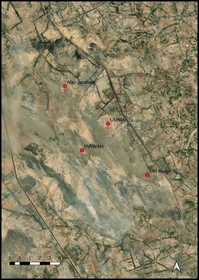
3. The Impact of Desertification on the Archaeological Site of Umm al-Aqarib
Desertification has emerged as one of the most significant environmental threats facing archaeological sites in southern Iraq. The site of Umm al-Aqarib, located within an environmentally fragile landscape, has experienced accelerated sand movement in recent years. This study examines the extent of sand encroachment and its direct impact on the preservation of architectural and cultural remains at the site.
3.1 Sand Movement and Vegetation Loss
Recent comparisons of satellite imagery reveal that large areas of the Umm al-Aqarib site have been severely affected by the advance of sand dunes. This phenomenon is closely linked to climate change, prolonged drought, and the subsequent loss of vegetation cover surrounding the site. The removal of vegetation has left the upper soil layer loose and unstable, facilitating the movement of vast quantities of sand onto the archaeological remains.
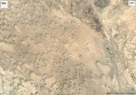
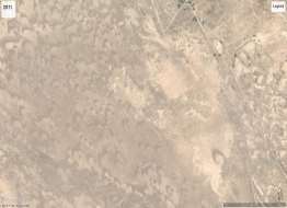
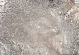
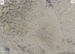
Fig. 2. Time sequence showing the principal wave of sand and the surface changing depending on
the season and date the images were shot (Source: Google Historical Archives).
3.2 Visible Damage Observed in Satellite Imagery
The extent of destruction caused by this environmental transformation is clearly observable through satellite data. The progressive advance of sand, unimpeded by any natural vegetation barrier, has resulted in the disappearance of numerous architectural features excavated during the 1990s. Many of these structures are now either buried or barely detectable in recent satellite imagery (Figure 2).
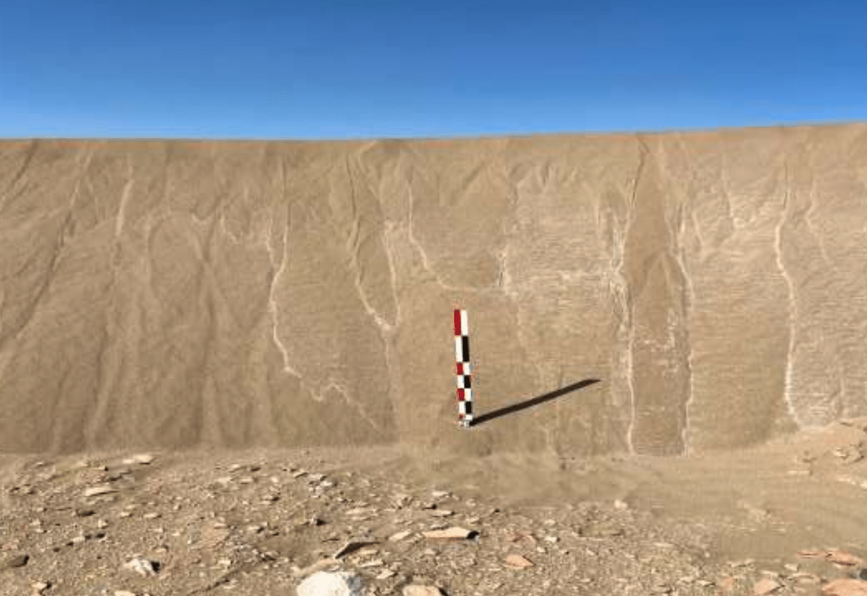
3.3 Structural Degradation Caused by Sand and Gravel Transport
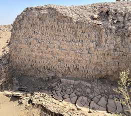
In addition to sand accumulation, gravel transported by wind has contributed significantly to the erosion and destruction of ancient architectural elements. This damage is especially evident in structures built of mudbrick, including those constructed using the “reinforced plano-convex brick” technique, which became widespread during the Early Sumerian periods of the third millennium BCE. Over time, the continued movement of sand and gravel is likely to result in further loss of these fragile architectural remains (Figure 3).
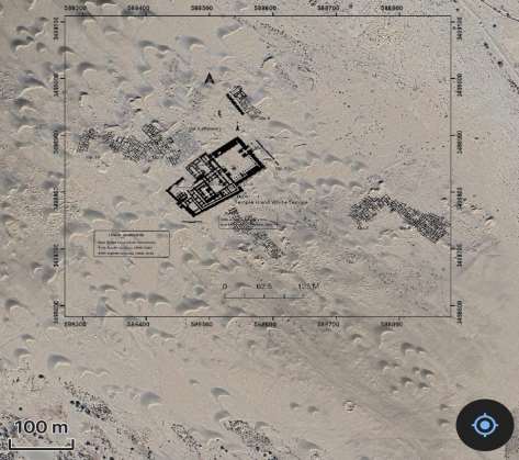
It can be observed that the architectural structures uncovered by the earlier excavations, including the Great Temple, appear in satellite imagery to be no longer visible, or at least large portions of them have deteriorated and become buried beneath substantial amounts of shifting sand. (Figure 4).
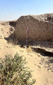
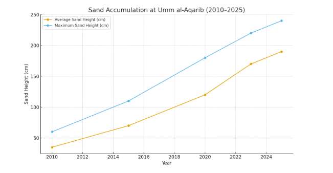
3.4 Severity of Sand Accumulation
Recent measurements indicate that sand deposits at the site have reached heights exceeding two meters in some areas. Such extensive accumulation poses an immediate threat to the site’s archaeological integrity. The burial of the site under deposits of this magnitude raises critical questions regarding the feasibility of future excavation efforts and the long-term risk of the sitebecoming completely submerged and eventually lost (Figure 5).
The ongoing process of desertification at Umm al-Aqarib represents a major challenge to archaeological preservation and research. The combined effects of vegetation loss, shifting sand dunes, and gravel transport have already caused substantial damage to exposed architectural remains. Without intervention—such as re-establishing vegetation cover, stabilizing soils, or implementing protective barriers—large portions of the site may continue to degrade or become permanently buried.
4. Monitoring Climate Change and Desertification at the Archaeological Site of Umm al-Aqarib Using Satellite
The archaeological site of Umm al-Aqarib in southern Iraq is highly vulnerable to the accelerating impacts of climate change, particularly desertification. Monitoring these environmental changes has become essential for understanding the threats facing the site and for developing strategies to protect its cultural heritage. Satellite remote sensing combined with climate model outputs provides an effective approach to track environmental degradation over time and to anticipate future risks.
Satellite imagery offers continuous and objective observations that allow researchers to detect early signs of desertification around Umm al-Aqarib. High-resolution multispectral and thermal sensors enable the monitoring of key indicators such as vegetation cover, soil moisture, land surface temperature, and the expansion of sand dunes. Time-series analysis of satellite data—using platforms such as Landsat, Sentinel, and MODIS—reveals long-term trends in land degradation, including declining vegetation indices, increasing surface temperatures, and the encroachment of desert sands toward the archaeological mounds. These observations help clarify how climatic stressors and human activities are transforming the landscape surrounding the site.
This combined approach supports the development of early-warning indicators and risk- management strategies. For example, tracking annual vegetation cycles can help identify periods of extreme dryness that may increase erosion, while monitoring dune movement provides insights into sediment dynamics that could bury or damage the site. Such information is crucial for heritage management teams seeking to implement protective measures, such as erosion control, site stabilization, or the rehabilitation of surrounding vegetation (Figure 6).
In conclusion, climate change and desertification represent major challenges for the long-term preservation of Umm al-Aqarib. The integration of satellite remote sensing with climate modelling offers a powerful framework for understanding how environmental conditions are evolving and for designing science-based strategies to protect this significant archaeological landscape. This monitoring approach ensures that decision-makers and researchers have the necessary information to mitigate risks and safeguard the site for future generations
5. Archaeologists at the Umm al-Aqarib Site
Throughout my work at this site, I have had the opportunity to meet with many archaeologists who fully recognize its importance within this site. Several researchers have focused their master’s theses on this site, while others have examined the architectural features of Umm al-Aqarib in comparison with temples and other structures from various Sumerian sites.
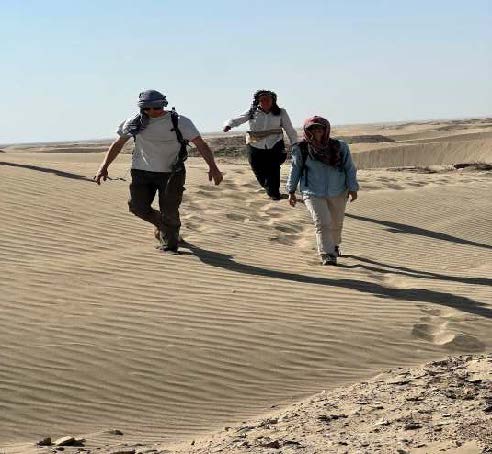
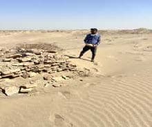
Mathilde Mura, a professor at the University of Paris who studied the site of Umm al-Aqarib as part of her master’s research ten years ago—and who is currently visiting the site alongside the Tell Um al-Ajaj archaeological mission near Umm al-Aqarib—stated that she has been monitoring the threats facing this site through remote sensing technologies, particularly the advancing processes of desertification. She explained that she is fully aware of the site’s significance to the civilization of Mesopotamia and expressed her shock at the neglect that has allowed the site to confront these challenges without intervention. She added that “we are on the verge of losing a site whose story remains incomplete,” noting that essential architectural structures are deteriorating each year, while desertification advances at an alarming rate. Professor Moura is currently working to persuade international institutions to contribute to the preservation of this important heritage site. (Figure 7).
Amaury, a member of the Umm al-Ajaj team who specializes in comparing Mesopotamian archaeological sites, emphasized that it is our collective responsibility to preserve this important site. He compared the main temple at Umm al-Aqarib with those at other sites by the remote sensing technique and noted the significant accumulation of sand covering the temple and surrounding structures.