


2019 POSTER ABSTRACTS
Posters are listed alphabetically by the presenter’s last name.
CHAIR: Jennifer Ramsay (The College at Brockport, State University of New York)
- Aaron Greener (W. F. Albright Institute of Archaeological Research), Matthew J. Adams (W. F. Albright Institute of Archaeological Research), and Conn Herriott (The Hebrew University of Jerusalem), “A Bowl of Bulls: EB IVessel with Bovine Symbolism from Tel Megiddo East”
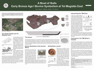 The EB I (ca. 3300–3000 B.C.E.) site of Tel Megiddo East—situated in the heart of the Jezreel Valley in northern Israel—was excavated by the Jezreel Valley Regional Project from 2010–2013. A unique large platter with three interior protrusions, resembling bull horns, was found at the site, along with fragments of additional similar vessels. The restoration of this vessel led to the discernment of previously unidentified pottery stumps which were discovered at contemporaneous sites such as Qiryat Ata and Yaqush.
In this poster we present the vessel and analyze the relationship between the bovine motif and the vessel’s physical and social context. Bull symbolism and cult were popular during the EB I in the southern Levant and beyond. For example, cattle are the most commonly represented animals in the zoomorphic figurine repertoire. Within the general body of cattle symbolism, a particular emphasis on heads and horns is apparent. It is possible that horns were distinctive visual shorthand for complete crania, whole animals, or particular ceremonies.
The EB I settlement at Tel Megiddo East and the temples on Tel Megiddo provide new evidence for significant developments in monumental architecture, centralized planning, and remarkable control of resources that presage the “urban” societies of the EB II/III. In such a context, utilitarian objects of symbolic importance may have been fashioned by craft specialists who functioned under the auspices of the temple.
- Donovan Adams (University of Nevada, Reno) and Marin Pilloud (University of Nevada, Reno), “Investigating Kinship of Early Neolithic Communities in Anatolia”
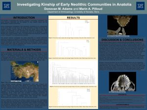 The social organization of early Neolithic communities is not well understood. The Neolithization process was comprised not only of an adoption of new subsistence and technological strategies, but also of changes in social structure and the demographic composition of Anatolian populations. Previous research has indicated increased fluidity in how people organized themselves, with mortuary treatment of individuals being based along social, rather than biological, ties (Pilloud and Larsen, 2011). The present research serves to investigate how four communities dating from the Early to the Late Neolithic period in central and northwestern Anatolia were organized. These samples offer an opportunity to assess kinship construction throughout the Neolithic and the Anatolian peninsula. Dental morphological and metric data on permanent dentition were collected on samples from Çatalhöyük, Aşıklı Höyük, Boncuklu, and Barcın Höyük. Gower’s coefficient of similarity was used to analyze phenotypic similarities between individuals as this technique accommodates both types of data. Results indicate a changing relationship with biological affinity over time as the process of Neolithization progressed.
- Rami Arav (University of Nebraska Omaha) and Ann Haverkost (University of Nebraska Omaha), “A New Iconic Stele and High Place at Bethsaida”
The 2019 season at Bethsaida focused on exposing more of the Area A Stratum VI city gate complex, dating to the 11th to the 10th centuries B.C.E., where a new iconic stele and high place were discovered. The iconic stele and high place were located on the corner of what was probably the southeast tower of the courtyard “between the two gates.” Made of basalt, the stele is reminiscent of the one found at Bethsaida in 1997, only smaller and in a more rudimentary form and gives us an idea of how the image of the god evolved during the Iron Age.
It is the sixth and oldest stele ever found of this image and the second at Bethsaida. Three stelae were found in southern Syria and one in Gaziantep in southern Turkey. The icon has been identified as the moon-god of Haran, but, according to some scholars, it has similarities to storm god Haddad of Damascus. The moon god was the focus of a major cult for the Aramaeans, and it seems that the Arameans of the Kingdom of Geshur and Bethsaida, its capital city, followed the Arameans to the north and the Chaldean dynasty of Babylon. This major find adds further evidence for the ancient site’s links to the north. It clearly shows that, despite the differences and gaps in occupation between Stratum VI and V (ca. 850 B.C.E.–732 B.C.E.), the population of Bethsaida still remained the same.
- Jaime Bennett (La Sierra University), “Conservation Process of Loom Weights Found at Khirbat al-Balu‘a”
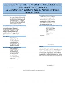 Loom weights were found during the 2017 season at Khirbat al-Balu‘a and during the 2019 season as well within a casemate room in an Iron Age phase of the fortification wall. Typological and comparative study of the loom weights from Khirbat al-Balu‘a will reveal information about the textiles produced which, given the context of the loom weights in the casemate room, may indicate specific economic activity. The poster will show the conservation process of these loom weights both in the field in situ this summer and in the lab as well from the 2017 season.
- Katherine Burge (University of Pennsylvania) and Petra Creamer (University of Pennsylvania), “Modeling Mud Brick Construction Practices at Kurd Qaburstan”
Kurd Qaburstan is a 109 ha urban site in northern Mesopotamia, southwest of Erbil in the Kurdistan Region of Iraq, currently excavated under the direction of Professor Glenn Schwartz of Johns Hopkins University. It has tentatively been identified as ancient Qabra, a large kingdom known from textual sources from the first half of the second millennium B.C.E. The 2017 excavation season revealed a Middle Bronze Age monumental building on the central mound, the collapse layers of which contained a number of painted Halaf-ware sherds, suggesting that the bricks were made on or near Halaf occupation somewhere in the vicinity of the site.
Our study uses GIS applications to model potential brickmaking locations around Kurd Qaburstan, by setting up a series of conditions for what a brick-making site requires based on ethnographic examples (e.g., water source, surface area, obstructed river bank). We cross-reference these results with Halaf-period sites mapped by the Erbil Plain Archaeological Survey (directed by Jason Ur of Harvard University). Using cost-path analysis to determine efficiency of transport from these locations to the central mound, we identify probable brick making sites used in this monumental building project. In addition, we calculate rates of labor for every step of the construction process. In examining and modeling mud brick building practices at the site, we aim to shed light on some of the organizational mechanisms related to the overall process of urbanization in Middle Bronze Age northern Mesopotamia and consider some of the underlying socioeconomic realities that are otherwise difficult to perceive.
- Scott Coleman (University of Calgary), “The Multifaceted Evolution of Byzantine Çadır Höyük’s Socio-Economic Environment: A Case Study of the Numismatic Evidence”
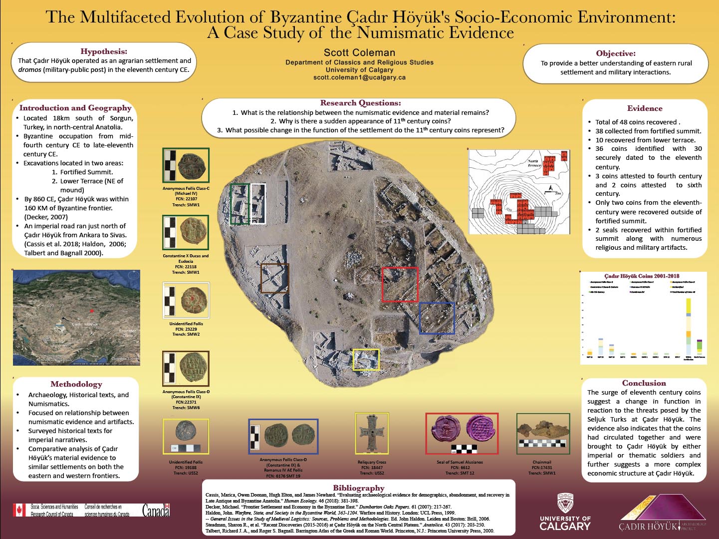 Historically, Byzantine studies have focused on urban centers, overlooking the remote rural villages and towns of central Anatolia. Though modern scholarship has shifted its focus and recognized the importance of such secluded settlements, evidence clarifying how rural agrarian life operated in Byzantine central Anatolia continues to be limited. The Byzantine settlement at Çadır Höyük, located in central Anatolia, Turkey, is the focus for this case study. The objective of this study is to present and discuss the extensive numismatic evidence which helps explain Çadır Höyük’s economic status and function during the Byzantine period. The discipline of numismatics continues to be a specialized field of study that often isolates coins from their depositional contexts for an independent analysis. The utilization of coins for dating archaeological contexts oversimplifies their relationships with other material remains. For Çadır Höyük, the relationships between numismatic and physical evidence not only demonstrate a continual occupation period from the mid-fourth century to the end of the eleventh century but also suggest the settlement’s ever-evolving utility over the centuries. An interdisciplinary approach allows for a deeper understanding of the relationships between the numismatic evidence and other material remains recovered at Çadır Höyük. This methodology presents scholars with the opportunity to further elaborate on the social relationships that existed both within the settlement and externally. The study’s conclusions will demonstrate the multifaceted and changing economic environment and social relationships as the populations changed at Çadır Höyük.
- Christopher Davey (Australian Institute of Archaeology; University of Melbourne), Luis Siddall (Australian Institute of Archaeology), Carla Raymond (Macquarie University), and Joseph Bevitt (Australian Nuclear Science and Technology Organization), “Hidden Text: Imaging and Reading an Ancient Tablet Encased in an Envelope”

A tablet from Nimrud, which is encased in an inscribed clay envelope IA5.074 (ND 3430; Postgate 1976), was imaged at the Australian Synchrotron Imaging Medical Beamline. This confirmed that there was a cuneiform tablet inside the envelope, the text of which could be read. The poster provides the details of the imaging, describes the tomography, offers a reading of the enclosed tablet, and comments on the variation between the text on the envelope and that on the tablet and the significance of this for Assyrian contract law.
- Victoria Doran (Queen’s University), “A Study of Christian Symbolism at the Site of Humayma, Jordan”
This project focuses on the documentation and analysis of Christian symbols found throughout the archaeological site of Humayma—a town in southern Jordan that transitioned from a Nabataean caravan stop and Roman military fort into a prominent Christian settlement during the Byzantine period. Overall, the aim of this study is to contextualize the presence of Christianity within the multi-cultural framework of Humayma, and to highlight the role of symbolism in Christianity, as a means of protection, identification, and communication between diverse peoples, the environment, and the supernatural. As part of this poster, I consider symbols from two different areas of Humayma; the Eastern Cascading Plateau of the Jebel Qalkha and Field D128, an area west of the Roman military fort. First, I suggest that a petroglyph carved into the Eastern Cascading Plateau is a monogram of Saint Michael the archangel. This is a particularly significant finding, because the Plateau, an area with a long history of Nabataean, Roman, and Islamic use, has never before been associated with Christianity. Next, I demonstrate that D128 may contain a Christian cemetery and/or church, based on the high concentration of Christian symbols found on spolia in that particular field.
- Jacob Finegan (University of Central Florida) and Tiffany Earley-Spadoni (University of Central Florida), “The Rise and Fall of Urartu: Observations on the Temporal and Spatial Distribution of Inscriptions from the Corpus dei Testi Urartei ”
 Tracing the expansion, decline, and ultimate demise of Urartu (ca. 900–700 B.C.E.) is critical to understanding the dynamics of that ancient state as well as its relationship to the Neo-Assyrian empire. Previous scholarship sought to define Urartian borders by using the distribution of pottery or metalwork as proxy indicators of presence. However, these techniques utilize gross chronological markers which flatten key historical developments as well as prompt legitimate debates about the material correlation of sovereignty. Instead, the described research seeks to understand the extent of Urartu—a network empire—using in-situ rock-cut inscriptions as a proxy. Due to the inscriptions’ association with individual rulers, we argue that the CTU (Corpus dei Testi Urartei) data allow Urartu to be examined on a finer timescale. The project complements contemporary scholarship which views Urartu as a network empire: a non-territorial polity that is centered around fortified nodes of influence. The findings, furthermore, challenge the plausibility of defining “borders” in certain ancient Near Eastern states like Urartu.
- Catherine Foster (U.S. Department of State), “Protecting and Preserving Archaeological Sites and Objects through International Agreements”
In 1983, the United States became a State Party to the Convention on the Means of Prohibiting and Preventing the Illicit Import, Export and Transfer of Ownership of Cultural Property (UNESCO 1970). Since that time, implementing legislation has allowed the United States to enter into bilateral cultural property agreements with 18 countries including some in North Africa and the eastern Mediterranean. These agreements promote stability, economic development, and good governance in other countries, while denying critical financing to terrorist organizations and other criminal networks that engage in illicit trade. Not only have these agreements helped to staunch the pillage and trafficking of cultural property by establishing U.S. import restrictions, they have provided a framework by which countries—through governments and cultural institutions including universities and museums—collaborate on activities of mutual interest. These include archaeological excavations, exhibition and research loans, educational training and professionalization, and preservation of archaeological and historical sites. Despite these positive and impactful outcomes, these binding international agreements are unknown to or a source of confusion for many scholars. This poster will explain clearly how agreements are forged and maintained, and how they can support best practices for the benefit of all stakeholders.
- Katharina Frankson (University of British Columbia), “Engaging Gardens: A Visual and Spatial Analysis of the Gardens at Herod’s Third Palace”
Herod the Great’s Third Palace at Jericho was one of his most elaborate palaces. My research examines how Herod and his architect used the design of the palace to control a guest’s experience and encourage certain activities within and around the palace’s green spaces. This palace complex contains two interior gardens housed within peristyle courtyards as well as the largest exterior garden of those associated with any of his palaces. I use a visual and spatial analysis of these gardens to examine how physically and visually accessible they were to their owner and his guests. My work takes into consideration the specific context of each garden in order to understand how it was meant to be experienced. I investigate how the design of the palace controls the way visitors and occupants engaged with these gardens.
My analysis indicates that each of the three gardens has a different relationship with its surroundings and that each is meant to be interacted with in multiple ways from various vantage points. I explore their unique features and placement within the palace, to investigate how they complement and encourage specific palace activities. By contextualizing the role of the gardens within the palace complex, I am able to emphasize the range of possible activities that took place around the gardens and highlight their importance to Herod. This poster represents a portion of my larger MA thesis which looks at how this palace facilitates social interaction through its design and decoration.
- Amanda Gaggioli (Stanford University), “Earthquake Destruction at Antiochia ad Cragum and Blaudos in Western Turkey: A Perspective from Soil Micromorphology”
 The subfield of archaeoseismology uses archaeological data to establish deeper time perspectives on the relationships between sociocultural development and recurring earthquake hazards. Previous studies in the eastern Mediterranean have focused on architectural remains and their destruction types in order to identify and interpret past earthquake events and their sociocultural consequences. Since not all architectural destruction types can be conclusively attributed to earthquakes, this project advocates for an interdisciplinary approach that analyzes sediments together with architectural remains in archaeoseismic excavations. I demonstrate the advantages of using the geoarchaeological method of soil micromorphology in two archaeoseismic cases in western Turkey: the Roman site of Antiochia ad Cragum and Byzantine site of Blaundos. Seismic activity has an impact on soil formation, and techniques in soil micromorphology have the potential to aid in establishing temporal and spatial linkages between observed material destruction and earthquake events. My project analyzes evidence for seismic activity in soils from the stratigraphic levels associated with the foundations of damaged structures. Evidence for past earthquakes in soil formation includes various types of liquid escape microfeatures and soft-sediment microstructures. The presence of seismically induced soil features in the stratigraphy at level with building destruction provides more conclusive evidence for the association between earthquakes and remains of building destruction. This project advances the use of soil micromorphology for studies of seismic phenomena at archaeological sites and contributes to more sophisticated understandings of the relationship between human communities and seismic environments in the ancient eastern Mediterranean.
- Caroline Gerkis (Independent Scholar), “Fluidity of Ptolemaic Funerary Architecture”
The concept of the final resting place is manifested in funerary architecture, an important belief that resonated throughout all ancient cultures. Upon the death of Alexander the Great, his Successors (the Diadochi) fought one another to possess his body, to use it as a symbol of legitimacy to control his empire. The man who successfully accomplished this was Ptolemy Lagides—who seized Egypt soon after his death in 323 B.C.E.—by hijacking Alexander’s corpse, which was taken to Egypt and eventually interred in the Sema (the royal mausoleum) at Alexandria. Consequently, Ptolemy I Soter reigned as the first Ptolemaic king (305–4 B.C.E.) over this ancient Pharaonic land until the death of Cleopatra VII (30 B.C.E.), illustrating the power of funerary architecture and its significance both as a cultural tradition and as an expression of this originative society.
This poster displays the distinctive architectural identity that was created and associated with the Ptolemaic dynasty and how it is demonstrative of their fluidity as rulers of this ancient land. The amalgamation of Ptolemaic funerary structures that integrated local cultures with Macedonian traditions, ranging from innovative tombs built at Alexandria and hybrid-structures at the Tuna el-Gebel necropolis, to acclimating local customs, such as mud brick tombs at the Assasif cemetery on the Theban necropolis, exhibits the sovereignty of the Ptolemies.
- Madaline Harris-Schober (University of Melbourne and Ludwig-Maximilians-Universität München), Gemma Lee (University of Melbourne), Lily Nash (University of Melbourne), and Thomas Keep (University of Melbourne), “Positive Organizational Psychology in Archaeological Field Work: A Preliminary Approach”
 The past ten years have seen a rise in positive organizational psychology in a variety of workplaces, most prominently schools and large corporations. The study of positive psychology and positive organizational psychology is the science of positive subjective experience, individual traits, and positive institutions (Donaldson 2011). We believe the application of these new approaches to archaeological field schools and/or fieldwork programs would increase staff and student fulfillment and overall individual and group flourishing while lowering negativity that can be caused by high-intensity fieldwork environments. Historically, archaeology is an “old world” profession and institution analogous with travel and hard physical labor. The archaeological dig is a unique form of institution and workplace which requires a universal set of guidelines to help those in leadership positions apply positive organizational techniques. While ASOR’s CAP (Committee on Archaeological Research and Policy) guidelines exist, they tend to focus on gender-based violence/harassment and how to deal with situations once they have occurred. The aim of this research is to expand on issues brought to light during the 2018 ASOR session, “Talking About: How to Make Fieldwork Safe from Gender-Based Violence, Harassment, and Discrimination” from a ground-up approach, utilizing new positive organizational psychological and behavioral methods which have proven beneficial in large organizations, such as ACR (Active Constructive Responding), autonomy supportive leadership, and PPIs (Positive Psychology Interventions). Moreover, we aim to implement an archaeologically specific study in order to promote and encourage positive excavation environments that foster group and individual flourishing rather than guidelines for damage control.
- Hidemasa Hashimoto (Tenri University), Hidetoshi Tsumoto (Ancient Orient Museum, Tokyo) and Hisao Kuwabara (Tenri University), “Chemical Composition of Bronze Artifacts from Tel Rekhesh”
![]()
Tel Rekhesh is an archaeological site located in Lower Galilee, Israel. Its ancient name is suspected to have been Anaharath, according to the provenance study of Amarna Letters. As a result of several seasons of excavations by Japanese-Israeli excavation team, it has been elucidated that settlement of the site has a long, continuous history from the Early Bronze Age to the Roman period (except the Hellenistic period).
In this poster, the authors present unpublished results of XRF (X-ray fluorescence) analysis conducted on the bronze artifacts unearthed during the 2006–2010 excavations. Thirteen bronze items, from the Late Bronze Age to the Roman period), were analyzed in total. The results of XRF analysis of the bronze objects revealed that some items, such as a chisel, stunning bolt, bronze pin, and bronze pin head do not include lead (Pb) among their components. The authors suggest the possibility that the absence of lead in certain bronze objects is the result of the intentional choice of metal workers, rather than time differences of items or a historical development. The reason for this choice might relate to manufacturing techniques used or the characteristics of end products. For example, the absence of lead in a chisel could be understood from the necessity of hardness as a metal tool used for engraving or cutting. In order to verify the suggestion by the authors, published data on the chemical composition of bronze artifacts from other sites are also examined.
- Blair Heidkamp (The University of Texas at Austin) and Yorke Rowan (University of Chicago), “A Spatial Analysis of Ground Stone Tools from W80 at Wisad Pools, Jordan”
One of the study areas for the Eastern Badia Archaeological Project is Wisad Pools, located in the Black Desert of the panhandle of eastern Jordan. The pools, which fill with the annual rains, are surrounded by hundreds of stone-built structures, presumably from the Late Neolithic. Excavation of one structure, W80, revealed complex stratigraphy with occupational deposits spanning 1000 years. Throughout the intermittent periods of use, a pattern became apparent in which most hand stones were deposited up against the interior walls of the structure. The particular positioning of these tools implies that the placement was in fact intentional, possibly while the structure was occupied and during periods of abandonment. Previous interpretations of the area have argued that the structures at Wisad Pools were occupied seasonally to take advantage of gazelle herd migrations (Rollefson et al. 2014, 2018; Rowan et al. 2017). Securing the ground stone tool’s position indicates an intent to return to the same region and the same structures again. By investigating the spatial distribution of the various ground stone tools found at W80 we hope to gain further insight on the cyclical process of humans interacting with the region.
- Ian Hill (Heritage and Archaeological Research Practice), “Archaeological Field Schools in a Changing World: Exploring a New Model for Training”
With over a decade of funding cuts in the UK, particularly real-term funding cuts to the arts, culture, and environment, coupled with a shift from government funding to higher university tuition fees, traditionally funded archaeological research excavations may become a thing of the past. Archaeological field schools and volunteer-driven community outreach projects are becoming more prevalent than ever before. But do their standards, outputs, and research questions compare to traditional research excavations and commercially or developer-funded archaeological works?
Using the case study of Kissonerga-Skalia in Cyprus, this poster will explore the project’s move from a university-run field school to an international field school operated by two not-for-profit organizations. The poster will examine the advantages and disadvantages of field schools principally aimed at university students, early career archaeologists, and archaeological enthusiasts. These advantages and disadvantages will be compared to traditional research excavations run by a university or museum, and developer-funded archaeological excavations run by a commercial archaeological contractor.
This poster will also develop ideas and approaches in how to run a successful field school that can provide a suitable balance between appropriate training for students, achievable research aims and targets, and the impact on the local area both economically and culturally.
- Julian Hirsch (Oberlin College), “The Oberlin Near East Study Collection (ONESC): Revitalizing an Archaeological Collection through Student Collaboration”
Housed in Oberlin College’s Religion department, the Oberlin Near East Study Collection encompasses a wide variety of archaeological material from the southern Levant. Collected from the 1930s–1980s, the roughly 650 artifacts cover a vast time span from the Epipaleolithic to the Modern period. As a teaching collection within Oberlin’s School of Theology and later in the College’s Department of Religion, professors of biblical studies used the objects to vivify biblical texts for generations of students. Starting in the 1980s, the collection fell into disuse. In Spring 2018, a student-led initiative was founded to digitize and revitalize this collection. This initiative has seen great success with numerous student volunteers contributing their time to record hundreds of artifacts. Participants have gained important skills in object photography, curation, and both archival and archaeological research. Our work has led to an improvement in the collection’s storage environment, laid the groundwork for its digitization, and has led to its increased use in class and club programming.
- Matthew Howland (University of California, San Diego), Brady Liss (University of California, San Diego), and Mohammed Najjar (University of California, San Diego), “Archaeological Storytelling and Community Engagement via Story Maps”
 Archaeology is 1) a fundamentally spatial field, 2) well-adapted to tell stories about the past and the people who lived in it, and 3) a field that often requires the development of close collaboration with the present-day inhabitants of regions around the world. As such, any given archaeological project should be uniquely suited to tell the stories of the past in four dimensions: the three dimensions of space, along with a fourth dimension of time that narrates the past and brings it into the present. The StoryMaps application, produced by ESRI, is a free service that allows for the generation of multimedia stories that visualize the kind of spatial data that archaeological projects regularly produce. While the app has potential as a scientific dissemination platform, it is perhaps best suited for narrating a story that explains past societies in a way that is not only comprehensible but also entertaining to the general public. Good archaeological practice in the 21st century would also suggest that this kind of public storytelling be aimed at engaging not only academics and their social circles but also the communities whose cultural heritage is the basis of the stories being told. To that end, this poster presents a StoryMap application telling the story of Iron Age copper production and social complexity in Faynan, Jordan, with the objective of sharing the story with the public in general but more specifically with the local communities of Faynan via installation of the StoryMap in Arabic into the newly-established Faynan Museum.
- Stuart Ibrahim (University of Melbourne), “And He Took the Fortified Cities of Judah”: Third Intermediate Period/Iron Age I–II Raphia and Egypt’s Response to the Changed Political Spectrum in the Levant”
Since 2017, I have analyzed the Bubastis Portal (a Third Intermediate Period Egyptian temple relief at Karnak) and the history of the New Kingdom Egyptian sites in the southern Levant/North Sinai border region, using an in-depth timeline to provide an alternative perspective. This analysis addresses what became of these sites (in relation to the contemporaneous political situation), in order to provide more insight regarding how things changed in the Sinai/Levantine region before Assyria emerged.
Despite the limited textual and archaeological evidence, the Medinet Habu battle relief and Papyrus Harris I (dating to the reigns of Ramesses III and IV in Dynasty 20) show that the Ways of Horus fortress chain (along the North Sinai coast, ending at Gaza) lasted until after Ramesses IV. Papyrus Golenischeff (Dynasty 21) and the archaeological evidence in the Eastern Nile Delta and southern Levant, though, confirm that two to four sites in the former region survived, while other groups resettled those in the latter (including Rafa) which were not abandoned.
After consolidating his power, the first Libyan king of Egypt (Dynasty 22), Shoshenq I, captured the remaining Ways of Horus sites (including Rafa). He then launched a three-pronged attack in the region of Israel, Judah, the Transjordan, and even the Negev (based on my analysis of the Bubastis Portal) to impose vassalage on the region. This briefly revived the Egyptian empire but also paved the way for later superpowers.
- Sanae Ito (Sophia University), “A Network Analysis of the Chief Scribe and the Palace Scribe in the Assyrian Empire”
The chief scribe and the palace scribe were the most important palace officials in the Assyrian Empire. Their duties included not only scribal work such as preparing royal inscriptions and writing royal letters, but also maintaining the royal archives and consulting scholarly literature. They occupied a crucial role as a secretary or an adviser of the Assyrian king. However, much uncertainty still exists about their relationship with other scribes, scholars, and palace officials. Thus, this poster examines their social network and seeks to explain how the chief scribe and the palace scribe carried out their work with or without the cooperation of other people. The research data in this poster are drawn from the texts published in State Archives of Assyria. The study offers some important insights into the duties, authorities, origins, and rivalry of the chief scribe and the palace scribe.
- Yiliang Li (University of Haifa) and Michal Artzy (University of Haifa), “Rethinking the Significance of East African Coasts in the Medieval Indian Ocean Maritime Trade System: An Archaeological Perspective”
The East African coast, known as the Swahili Coast, flourished along with the increasing maritime commercial contacts in the western Indian Ocean in the 9th–15th centuries before the coming of the Portuguese. The aim of this paper is to assess the status of the Swahili Coast in context by exploring the distribution of archaeological remains including ceramics, glass beads, and architecture.
Distinct imported commodities uncovered from the sites on the East African coast and islands, such as Chinese ceramics and Indian wound glass beads, imply that the Swahili Coast was involved in the frequently commercial interactions in the western Indian Ocean. Contacts are indicated by the distribution of East African plain wares from the littoral sites in the Arabian Peninsula as well. Nevertheless, timber and stone architecture, especially medieval mosques, developed from the mid-eighth century, while Islamic activities occurred on the East African coast.
Based on the quantitative and identifying study of archaeological data, it is assumed that East Africa coastal sites developed in the context of increasing Indian Ocean maritime trade from the ninth century onward, and that this activity was principally promoted by the merchant communities from the Islamic world. Lastly, the Swahili Coast was not the appendage of the monsoon trade network, but a significant bartering segment in the system.
- Brady Liss (University of California, San Diego), Matthew Howland (University of California, San Diego), Anthony T. Tamberino (University of California, San Diego), Scott McAvoy (University of California, San Diego), and Thomas Levy (University of California, San Diego), “Everything Old is New Again: Using Archived Photography to 3D Model Previous Excavations in Faynan, Jordan”
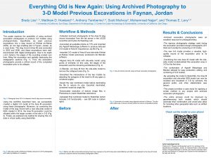
Archaeological research has recently embraced 3D modeling of sites/excavations using digital photogrammetry, but using photography to generally document excavations is a longstanding practice. While these excavation photos were not previously intended for photogrammetry, the rigorous digital photography strategies used by modern excavations afford an opportunity to potentially repurpose these archival data for 3D modeling. Moreover, these photos can return an excavation to its original state, before any damages of time. This poster explores the possibility based on archival photographs from excavations at Khirbat en-Nahas (KEN), an Iron Age copper smelting center in Faynan, Jordan. KEN was excavated by the Edom Lowlands Regional Archaeology Project between 2002 and 2009, and one excavation area, a large probe into a slag mound (Area M), has since collapsed. Due to its depth (ca. 6.5 m), the edges of the sounding eroded, filling the excavation and partially destroying the stratigraphic sections. However, the excavation was thoroughly photographed at its completion, providing a dataset to digitally reconstruct the area. Moreover, by combining the model of the slag mound with a new site-wide model of KEN created in 2014, the Area M excavation could be situated within the larger context of the site in 3D for the first time. This poster presents the methods and results of this process along with one method for sharing these data using virtual reality. In doing so, it provides a case study of combining new and archived photography to produce 3D models for the preservation and dissemination of archaeological sites/excavations.
- Leilani Lucas (College of Southern Nevada; University of Nevada, Las Vegas), “Shifting Harvests: Archaeobotanical Contributions to Our Understanding of the Cypriot Chalcolithic–Bronze Age Transition”
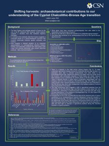 Current archaeobotanical research in Cyprus demonstrates a deviation from the mainland trajectory highlighting a prolonged period of mixed-subsistence economy of small-scale intensive garden cultivation and hunting to one that is reliant on crop-agriculture and intensive livestock herding. There is evidence for the spread of intensive mixed farming regimes from the mainland Levant by the end of the ninth millennium B.C.; however, Cyprus appears to pull back from this by the Late Neolithic. The data presented here argue for more flexible subsistence practices during the Neolithic and Chalcolithic with a shifting of strategies only in the Bronze Age. This paper summarizes the available archaeobotanical evidence from the Cypriot Chalcolithic–Bronze Age transition, and together with new data from Kissonerga-Skalia the rise of the Cypriot Bronze Age economy is explored.
- Thomas E. Levy (University of California, San Diego) and Mohammad Najjar (University of California, San Diego), “At-Risk World Heritage and the Digital Humanities—Recent Destruction at Khirbat en-Nahas, Jordan”
Cultural resources, like natural resources, are finite. Every country has cultural resources that reflect local history and prehistory and are vital both economically for tourism and socially as a foundation of cultural identity. This material cultural record is part of world heritage, something recognized by UNESCO since 1972 (http://whc.unesco.org). As archaeological and historical sites occur in relatively restricted areas, they are a limited resource that should be cared for, curated, and preserved for local, national, and international communities. Unfortunately, over the past seven years, more than any other region on the planet, archaeological heritage sites in the eastern Mediterranean and Middle East have suffered destruction at an alarming rate. Political instability, war, extreme ideologies, economic downturns, development, and other factors have led to the wanton destruction of heritage sites. The recent University of California Office of the President Catalyst grant (+ $1 million) enabled four UC Campuses to collaborate on using the methodology of cyber-archaeology (data capture, curation, analyses, and dissemination) to help address issues concerning the destruction of archaeological sites in this region. Here we discuss the recent (July 2019) destruction at Khirbat en-Nahas located within the protected Dana Biosphere Reserve of the Royal Society for the Conservation of Nature in Jordan, and how cyberarchaeology has recorded the site, created virtual reality models for the public, and contributes to monitoring damage at the site.
- Susan Penacho (ASOR Cultural Heritage Initiatives), “A Systematic Survey of Looting Pits at Khirbet al-Balu‘a, Jordan”
The site of Balu‘a has been and continues to be disturbed by looters over the course of many years. These disturbances fall into two categories: deep looting pits often dug along visible architectural features, and small shallow pits possibly dug after the use of a metal detector. During the 2019 season, a systematic GPS survey was undertaken to map identified disturbed areas within the Iron Age city walls. The survey’s goal was to create a baseline of previous looting in order to monitor new disturbances. A total of 201 disturbances were noted: 113 looting pits and 88 metal detector pits. These are described based on relative size ranging from extra-small to extra-large. Looting is an ongoing problem as we witnessed first-hand, with two looting events taking place overnight during the excavation season. This brazen looting of the site while excavations were ongoing illustrates the gravity of this issue. By monitoring both past and present looting, the project team aims to highlight the scale of the ongoing problem and brainstorm ways to combat future looting events at Balu‘a.
- Steven Porson (University of North Carolina at Charlotte), Patricia Fall (University of North Carolian at Charlotte), and Steve Falconer (University of North Carolina at Charlotte), “Early to Middle Bronze Age Paleoecological Analysis of Urban Collapse in the Southern Levant”
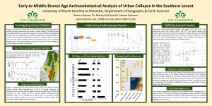 Our study involves an archaeobotanical and stable isotope analysis of seeds from ancient cultivated crops to test hypotheses for the collapse of Early to Middle Bronze Age cities in the Middle East. Preliminary analysis of seeds excavated from Early and Middle Bronze Age settlements in Jordan (ca. 2500–1600 cal B.C.) show signs of relatively decreased water availability correlating with increased temperatures during the latter stages of the Early Bronze Age collapse and improved conditions during the Middle Bronze Age urban redevelopment. Isotope results also seem to indicate the potential for a two-stage punctuated aridification event during EB IV abandonment. More detailed dissertation analysis will test the specific hypothesis that there were two periods of diminished environmental conditions at the end of the EB III and middle of the EB IV by incorporating new sites and proxies for a more thorough investigation of Near Eastern sites.
- Alexandra Ratzlaff (Brandeis University), Erin Brantmayer (The University of Texas at Austin), Ian Roy (Brandeis University), Tim Herbert (Brandeis University) and Helen Wong (University of Cambridge), “New Approaches in Digital Imaging”
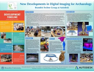 Through a partnership between Brandeis University and the Autodesk Boston Technology Center, the Brandeis Ancient Insights/Modern Innovations Team aims to create new technological approaches in digital imaging through the development of equipment and more specialized methodologies, using practical applications in the lab and field environments. Current in situ and artifact digital imaging allows for too much variation in data collection during the process of photogrammetry. One approach to this problem was to engineer and fabricate a Single Camera Automated Photogrammetry Platform to collect measured datasets at specified angles to reduce the processing error in modeling. The SCAPP BETA version incorporates a horizontal circular track in cut aluminum with two opposing carriages (3D printed in PLA filament and carbon fiber) that supports an arch with another carriage attached as a camera rig. The camera can then be adjusted at any vertical angle and the number of photos set to be collected on the horizontal plane. Adjustments in the vertical and horizontal planes allow for optimal data collection. The data sets collected with the SCAPP are run through multiple processing platforms. The advantage of this approach is that it provides modeling through programs designed for various specific needs such as lab-based applications vs. adaptability for the field. By processing in these different platforms, we can maximize the best methods approach in rendering 3D models. Our ASOR poster will highlight the advantages of the AIMI team’s partnership with Autodesk as well as results of the SCAPP BETA testing.
- Jackson T. Reece (University of California, San Diego), Anthony T. Tamberino (University of California, San Diego), Assaf Yasur-Landau (University of Haifa), and Thomas E. Levy (University of California, San Diego), “Roman Piscinae and Sea Level Reconstruction in the Southern Levant: Reexamining a Rock-Cut Installation at Tel Dor, Israel Using Aerial Photography and Ground-Level Photogrammetry”
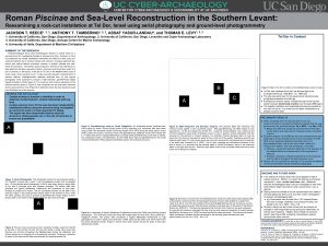 Roman fish ponds, or piscinae, have experienced a resurgence in recent publications on Mediterranean coastal archaeology, especially in Roman Italy and the central Mediterranean, as these installations can be useful proxies for estimating historical local sea levels. However, this renewed interest has highlighted a paucity of data on the common forms and uses of Roman aquaculture installations in the eastern Mediterranean, limiting our ability to conduct similar studies in the region. Rock-cut installations at Tel Dor, located on the southern Levantine coast (modern-day Israel), exhibits many of the characteristics common to Roman piscinae complexes and can provide a case-study for comparing piscinae along the eastern Mediterranean coast with more extensively documented piscinae in the central and western regions. The present study uses aerial photography and ground-level Structure from Motion (SfM) photogrammetry to document and visualize the Tel Dor piscinae in 3D and to situate the complex in its spatial context with the sea and immediately adjacent architectural features. A georeferenced orthomosaic and a digital elevation model (DEM) were created to precisely measure the dimensions of the structure for an accurate top plan and to analyze the circulation of water through the system. This project expands our knowledge of Roman coastal architecture in the eastern Mediterranean and improves our ability to reconstruct local sea levels in the southern Levant by identifying useful architectural proxies like piscinae that can supplement existing sedimentological and oceanographic datasets.
- Gilad Shtienberg (University of California, San Diego), Richard Norris (University of California, San Diego), Assaf Yassur-Landau (University of Haifa), Dafna Langgut (Tel Aviv University), Tammy Rittenour (Utah State University), Michael Lazar (University of Haifa), Katrina Cantu (University of California, San Diego), and Thomas E. Levy (University of California, San Diego), “The Kabara Marsh: An Opportunity to Unravel the Mystery of Holocene Natural and Anthropogenic Induced Environmental Change from the Carmel Coast, Israel”
The Holocene (ca. 12,000 BP–present) is characterized by ongoing environmental changes that have shaped the landscape leading to its present-day morphology. The overarching objective of this research is to investigate the complex human-environmental interactions while also gaining a unique prospective of social vulnerability to climate and environmental change along the coast of Israel over the Holocene. This investigation will be achieved by assessment of geochemical indicators, floral remains, and micromorphological markers that are found in the sedimentary profile. The Kabara marsh, located along Israel’s Carmel coast (full of habitation in both prehistoric and historic periods), consists of organic rich silty-clay sediments that were deposited continuously throughout the Holocene and thus possesses high potential for unravelling the mystery of the past. So far existing datasets have been collected and integrated into a single homogenous geospatial database. Building upon the understanding gained from a geospatially based ground model, four ca. 16 m-long boreholes were extracted from selected locations in a recent coring expedition that was conducted in the Kabara marshland. The cores consist of distinct cycles of gray clay and black peat that overlie a brown-red palaeosol. These sedimentological cycles presumably correspond to the wetter climates of the early to mid-Holocene while the palaeosol is associated with the Late Glacial Maximum (ca. 25,000 BP). Over the upcoming months the core sediments will be assessed through petro-sedimentological-biological analyses and linked with radiometric dating. Based on these new data, the environmental changes that occurred in the south eastern part of the Mediterranean and human impact will be better understood for the Holocene.
- Joanna S. Smith (University of Pennsylvania; The John and Mable Ringling Museum of Art), Helena Wylde Swiny (Harvard University; Kyrenia Ship Project), and Susan Womer Katzev (Kyrenia Ship Project), “A Cypriot Votive Ship Relief at The Ringling Museum of Art”
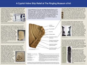
This poster centers on a Cypriot limestone votive relief fragment depicting a ship which is in the collections of The John and Mable Ringling Museum of Art (RMA) (SN28.1887). Its construction details compare with the Kyrenia Ship, a merchant ship built ca. 315–310 that sank in the early third century B.C.E. This relief sculpture adds to our understanding of Cypriot knowledge of ship construction and the votive significance of maritime imagery on Cyprus in the Hellenistic period. Luigi Palma di Cesnola unearthed the object that is said to be from a temple at Golgoi. Of the Golgoi sanctuary’s early Hellenistic period relief sculptures, a few represent nautical subjects such as boats and dolphins. Among these, the RMA fragment (17.4 cm in height) is the only representation of a large seafaring vessel. It depicts the starboard stern. A helmsman sits and holds the tiller connected with the quarter rudder. The carver had nearly correct knowledge of ship construction, from the rudder’s blade and stock (loom), to its box-like guard, to the railing and stanchions. The ship may be a war ship because the carver shows the ship’s planks (strakes) curving high up behind the helmsman. Although ship imagery at an inland sanctuary may seem surprising, the god Apollo, named in many of Golgoi’s votive inscriptions, was known in his guise as a dolphin for the safe passage of sailors. Possibly the relief references someone’s experience in a naval battle, as at Salamis in 306 B.C.E.
- Ariel Solis (Andrews University) and Rhonda Root (Andrews University), “Using BIM (Building Information Modeling) to Visualize and Share Archaeological Data at Tall Hisban, Jordan”
Today, the field of archaeology is seeking to expand beyond the traditional sharing of information through printed books and archaeological publications, to be more relevant by using various new technologies, such as 3D visualization, Building Information Modeling (BIM), and interactive media. We seek to continue to advance research that is being done in these areas. At Tall Hisban, Jordan (the first Madaba Plains Project archaeological site), many of these technologies are being used. However, the main objective of this project is to create a digital three-dimensional model of the tell (the entire site), showing the historical order of civilizations, how buildings were used in the past, and how they evolved over centuries. In order to accomplish this, the methodology will include fine art, photogrammetry, BIM, and GIS interacting together. This multi-disciplinary approach will integrate through collaboration of archaeologists, artists, architects, computer engineers, surveyors, and the local community. This is the first time that BIM is being used at Tell Hisban, to model the buildings, host the archaeological data, and illustrate the different historical time periods of the site. In this approach all this information will initially be contained within BIM, which will interact with other platforms, such as GIS and SQL. In addition, users will be able to interact with this information using virtual reality and augmented reality environments, which will expand to new audiences. The poster will contain a preliminary progress report on the findings from 2019.
- Lucas S. Stephens (Environmental Law and Policy Center) and Virginia R. Herrmann (University of Tübingen), “Mitigating the Climate Impact of the ASOR Annual Meeting: A First Appraisal”
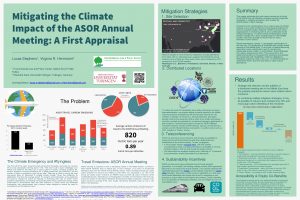 Emissions from transportation are a major cause of climate change, and routine conference travel leads academics to have an outsized carbon footprint. ASOR, as the host of an annual, international conference with over 1,300 attendees, must join other organizations in reckoning with its own contribution to this urgent and growing global problem. A further ethical consideration is that climate change has a more severe impact on the Mediterranean and Middle Eastern countries studied by ASOR than on many members’ home nations. This poster estimates the total carbon emissions of travel to the ASOR Annual Meeting, proposes several strategies to mitigate emissions, and models the effectiveness of each strategy. Recommendations include: 1) changes to the host city selection process to prioritize accessibility and reduce travel distance; 2) introduction and promotion of teleconferencing options; and 3) development of a behavioral incentives program to encourage sustainable travel modes. These strategies would carry the co-benefits of increasing opportunities for participants with disabilities, childcare obligations, difficulties acquiring visas to the U.S., or less financial support for conference travel, and thus are likely to raise overall attendance.
- Jade d’Alpoim Guedes (University of California, San Diego), Katrina Cantu (University of California, San Diego), Clara Dawson (University of California, San Diego), Ariana Garvin (University of California, San Diego), Brandon Gay (University of California, San Diego), Isabel Hermsmeyer (University of California, San Diego), Matthew Howland (University of California, San Diego), Xiyuan Huang (University of California, San Diego), Shelby Jones-Cervantes (University of California, San Diego), Bridget Lawrence (University of California, San Diego), Brady Liss (University of California, San Diego), Sunyoung Park (University of California, San Diego), Eric Rodriguez (University of California, San Diego), Julianna Santillan-Goode (University of California, San Diego), Luke Stroth (University of California, San Diego), Anthony T. Tamberino (University of California, San Diego), Fabian Toro-Uribe (University of California, San Diego), Isabell Villasana (University of California, San Diego), Zhen Yu (University of California, San Diego), and Thomas E. Levy (University of California, San Diego), “Analysis of the Paleobotanical Collection from Khirbat al-Jariya, an Early Copper Production Site in the Faynan, Jordan”

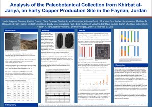
Archaeobotanical analysis has only rarely focused on industrial sites, yet the ways in which workers at these sites engaged in food provisioning and consumption may hold important lessons for understanding ancient patterns of trade and social organization. We present the results of an archaeobotanical analysis carried out at the copper production site of Khirbat al-Jariya (12th–10th centuries B.C.) in the arid Fanyan region, Jordan. A wide variety of plant remains has been unearthed at the site (such as grapes, wheat and barley) that may not have been locally grown and that may highlight trade routes to coastal areas, trade routes which have been already revealed through the analysis of copper ingots that traveled over 300 km away to the coast near Neve Yam in Israel.
- Berk Suleyman (Hunter College), “A Trip to Agade: Esarhaddon’s Journey”
The location of Agade, capital of the Akkadian realm, has eluded the academic community for decades. Many factors have complicated the search and identification of Agade, such as the lack of research done in the land of Akkad in recent years. Prominent theories regarding the location of this lost city indicate that it must have been positioned around the confluence of the Tigris and Diyala rivers, near modern-day Baghdad. In a letter, an emissary of the Neo-Assyrian king Esarhaddon named Mar-Ishtar attests that Esarhaddon was in Nineveh on the 15th, and then entered Agade on the night of the 20th in the same month. This study aims to map this journey and create a possible itinerary of this excursion that may offer new insights on the location of the lost capital. Known Neo-Assyrian settlements will be mapped which may have served as pit stops for the king and his entourage, and data from the Diyala Valley survey conducted by Robert McCormick Adams in the late 1950s that depict relict water courses from the Neo-Assyrian period will be incorporated and cross-checked with CORONA imagery to draw clearer continuations of these tributaries. The study will also include natural variables such as Tigris waterflow data, along with calculations from early archaeologists who used river transport in the region. All of this data will be transferred into ArcGIS for least-cost path and other spatial analyses to calculate which areas would have took Esarhaddon five days to travel to, illuminating the issue regarding Agade’s location.
- Katherine Titus (University of New Hampshire), Amy Michael (University of New Hampshire), and Jack Biggs (Michigan State University), “Preserving the Past for a More Ethical Future: Photogrammetry and Re-Analysis of a Bioarchaeological Sample from Çadır Höyük in Central Turkey”
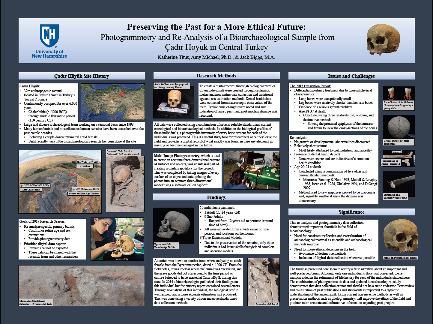 Many ethical issues arise when studying human remains, and the field of bioarchaeology has been fraught with ethical concerns for decades. Modern bioarchaeologists combat these concerns with the aid of modern technologies while concurrently rectifying the wrongs of their predecessors, as researchers are now more accountable through heightened awareness, education, and new legislation. One relatively new technology gaining popularity in this field is multi-image photogrammetry, which creates an accurate three-dimensional facsimile of surfaces and objects. Bioarchaeologists are now implementing this technology as an important research tool, but also as a means of promoting cultural heritage preservation. Using a sample collection from the Çadır Höyük site in central Anatolia, this study focuses on the digital preservation of juvenile and adult skeletal material dating between the Chalcolithic and middle Byzantine periods. The implementation of photogrammetry to the Çadır Höyük Archaeological Project collections during the 2019 field season generated a digital repository that can be accessed from anywhere. In addition to photogrammetric methods, the skeletal remains of an adult Byzantine woman were re-analyzed using updated bioarchaeological methods. The original interpretation of this burial was found to be inaccurate, thereby justifying the need for continuous interpretation of data contingent on new and improved methodologies. While exploratory, this research highlighted the importance of digital preservation of human remains and the application of current bioarchaeological methods at Çadır Höyük.
- Charles Wilson (The University of Chicago), “Room-Use Analysis of the Iron Age IIB Residential Quarter Houses at Gezer”
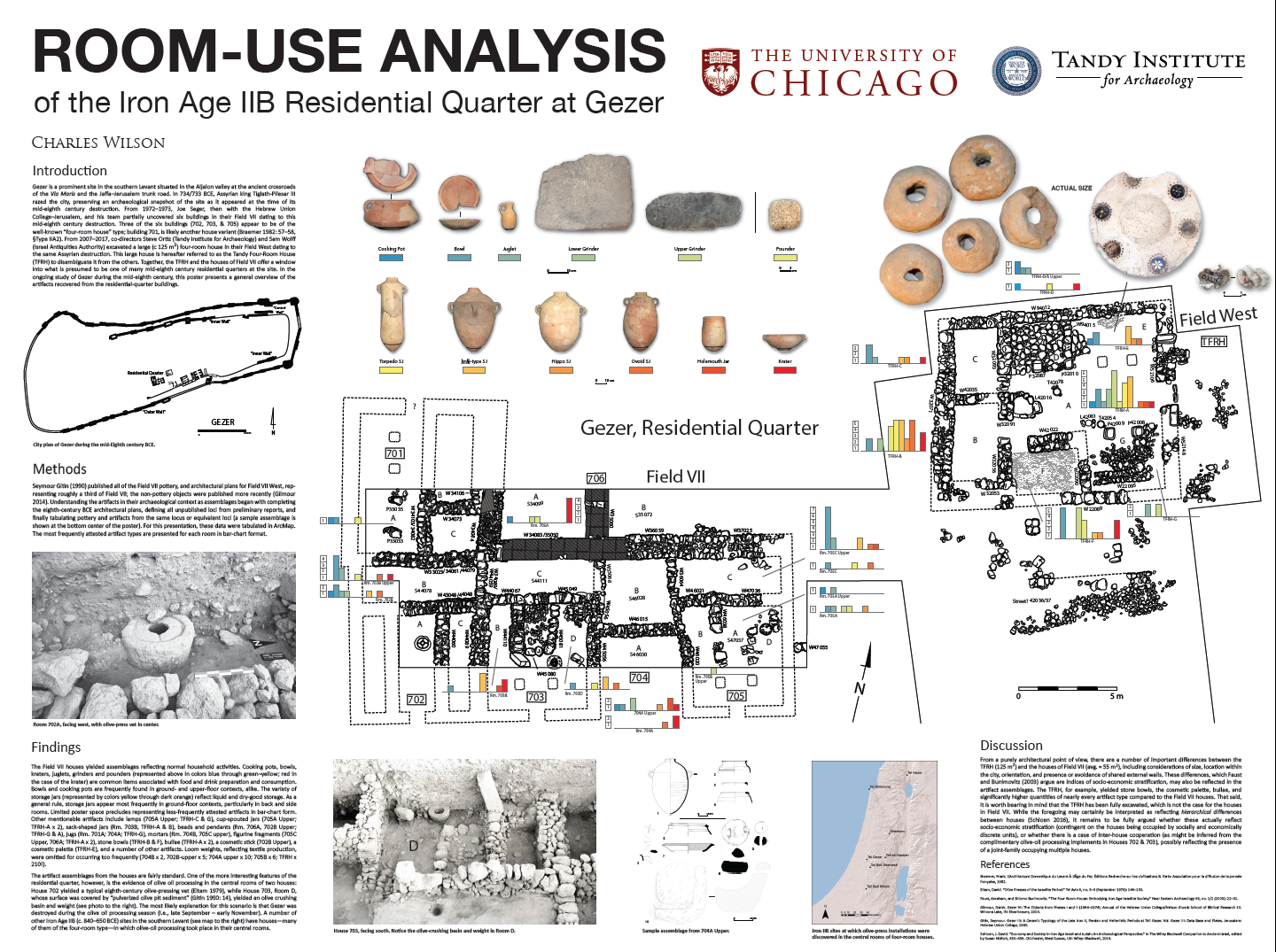 This poster presents the architecture and associated artifact assemblages from a number of residential-quarter houses at Tel Gezer, Israel dating to the mid-eighth century B.C.E. The domestic quarter was exposed by two archaeological expeditions: the first led by the Hebrew Union College-Jewish Institute of Religion, Jerusalem (HUC) in their Field VII from 1972–1973; and the second by Southwestern Baptist Theological Seminary (SWBTS) in their Field West from 2006–2017. HUC revealed parts of six buildings, most of them small houses (ca. 40–50 m2) and three of which appear to be of the well-known four-room house type. With the publication of the pottery and artifact classes from Field VII now complete, it is possible to identify room assemblages, and, from there, suggest tentative room functions. Adjacent in Field West, SWBTS uncovered a large (124 m2) four-room house, distinguished from the smaller houses not only in terms of size, but also in considerations of orientation, quality of construction, avoidance of shared walls, and proximity to the city’s public space. Together, the artifact assemblages, activity areas, and architectural alterations from these houses raise the possibilities of economic activities occurring and extended families being situated across more than one dwelling unit.