SHARE
[/vc_column_text][mk_image src=”http://www.asortest.org/wp-content/uploads/2017/01/social-fb-icon4.jpg” image_width=”42″ image_height=”42″ hover=”false” custom_url=”https://www.facebook.com/ASOResearch/” margin_bottom=”0″][mk_image src=”http://www.asortest.org/wp-content/uploads/2017/01/social-tw-icon4.jpg” image_width=”42″ image_height=”42″ hover=”false” custom_url=”https://twitter.com/ASOResearch?ref_src=twsrc%5Egoogle%7Ctwcamp%5Eserp%7Ctwgr%5Eauthor” margin_bottom=”0″][mk_image src=”http://www.asortest.org/wp-content/uploads/2017/01/social-in-icon4.jpg” image_width=”42″ image_height=”42″ hover=”false” custom_url=”https://www.linkedin.com/company/american-schools-of-oriental-research” margin_bottom=”0″][mk_image src=”http://www.asortest.org/wp-content/uploads/2017/01/social-ml-icon_7.jpg” image_width=”42″ image_height=”42″ hover=”false” custom_url=”mailto:info@asor.org” margin_bottom=”0″][mk_image src=”http://www.asortest.org/wp-content/uploads/2017/01/blog-icon3.jpg” image_width=”42″ image_height=”42″ hover=”false” custom_url=”https://asor.org/blog” margin_bottom=”0″][/vc_column][vc_column border_color=”rgba(255,255,255,0.01)” width=”1/6″ css=”.vc_custom_1490365673198{margin-right: 20px !important;border-left-width: 2px !important;padding-right: 20px !important;padding-left: 20px !important;border-left-color: #99422f !important;}” el_class=”sticky-sidenav”][mk_divider divider_color=”rgba(255,255,255,0.01)” thickness=”1″ margin_top=”3″ margin_bottom=”3″][vc_widget_sidebar sidebar_id=”ca-sidebar-60550″ el_class=”.widget { overflow: hidden; margin-bottom: 0; }”][/vc_column][vc_column border_color=”rgba(170,170,170,0.01)” width=”8/12″ css=”.vc_custom_1490225606852{margin-right: 10px !important;margin-bottom: 30px !important;border-right-width: 2px !important;border-bottom-width: 2px !important;padding-top: 30px !important;padding-right: 30px !important;padding-left: 20px !important;background-color: #ffffff !important;border-right-color: rgba(227,228,228,0.75) !important;border-bottom-color: rgba(227,228,228,0.75) !important;}”][vc_row_inner][vc_column_inner width=”1/4″ css=”.vc_custom_1590517099925{margin-right: 20px !important;}”][vc_single_image image=”61117″ img_size=”full”][/vc_column_inner][vc_column_inner width=”3/4″][vc_wp_text]ONLINE RESOURCES
ASOR Map Collections
[/vc_wp_text][/vc_column_inner][/vc_row_inner][mk_divider thickness=”1″ margin_top=”10″ margin_bottom=”10″][vc_row_inner][vc_column_inner width=”2/3″ css=”.vc_custom_1590550959746{padding-top: 30px !important;padding-right: 40px !important;}”][vc_single_image image=”73032″ img_size=”581 x 600″ onclick=”img_link_large” img_link_target=”_blank”][mk_padding_divider size=”10″][vc_wp_text]Map ID: MID000043 – Download Image
[/vc_wp_text][/vc_column_inner][vc_column_inner width=”1/3″][vc_wp_text]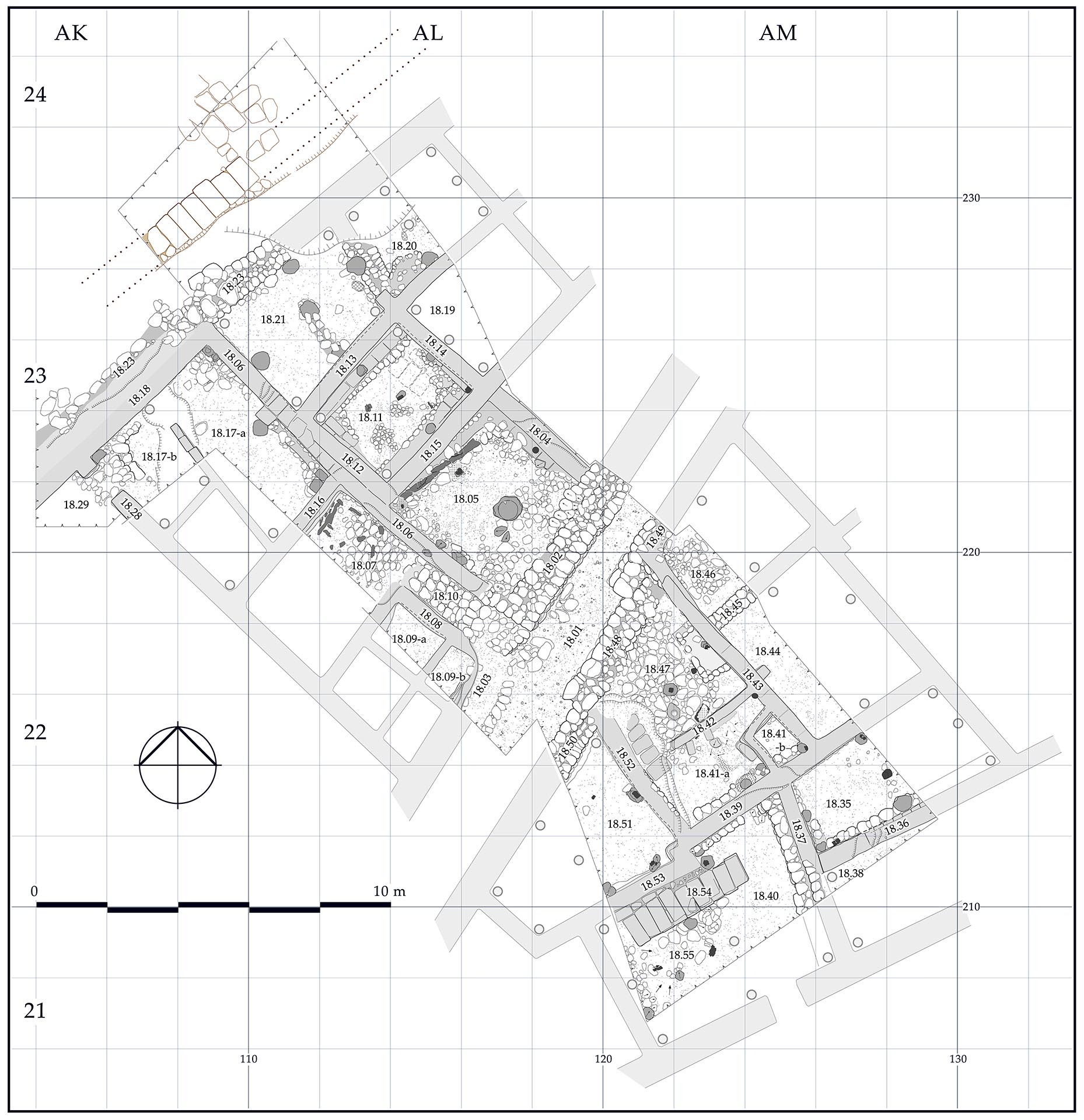
Tell Arqa, Lebanon: Plan of Level 18A
Country: Lebanon
Location: Tell Arqa
Area: Area I-West of the tell
Stratum: 18A
Description: Plan of archaeological structures of Level 18A (EBII)
Category: Architectural Plan, Archaeological Feature
Type: Houses and street dated to the Early Bronze Age II
Period: Early Bronze Age II
Date: 2750 BCE
Credit: Hanan Charaf, Tell Arqa Archives, September 2016
Back to Browsing Locations in Lebanon
Back to Browsing Maps[/vc_wp_text][/vc_column_inner][/vc_row_inner][mk_divider thickness=”1″ margin_top=”30″ margin_bottom=”30″][vc_row_inner][vc_column_inner css=”.vc_custom_1590517110399{padding-right: 20px !important;padding-bottom: 20px !important;}”][vc_widget_sidebar sidebar_id=”ca-sidebar-64142″][/vc_column_inner][/vc_row_inner][mk_divider thickness=”1″ margin_top=”30″][vc_widget_sidebar sidebar_id=”ca-sidebar-62968″][mk_padding_divider size=”20″][/vc_column][/vc_row][vc_row][vc_column][vc_column_text] [/vc_column_text][/vc_column][/vc_row]