SHARE

Not a Friend of ASOR yet? Sign up here to receive ANE Today in your inbox weekly!

October 2023

Vol. 11, No. 10

Beyond the Fertile Crescent: Life in the Black Desert

By Yorke M. Rowan


The forbidding landscape known as the Black Desert is created by lava flows stretching from southern Syria to northern Saudi Arabia that render this stretch of Jordanian desert difficult to traverse and inhospitable to permanent settlement. At approximately 50,000 sq. kilometers, the Black Desert is the largest volcanic field on the Arabian Plate. Despite currently arid to hyper-arid conditions, increasing evidence suggests that this was not always the case; whether due to higher rainfall or increased surface water retention, it appears that the Black Desert could at one time support humans, animals, and plants.

Figure 1: Map of area with location of sites. Map Data: Google, ©2018 Basarsoft

Situated beyond the traditional zone of the Fertile Crescent, the core area of neolithization, this rough territory saw only a few major research projects by pioneers such as Andrew Garrard, Alison Betts, and Svend Helms. Today, reinvigorated research projects explore different regions of the harra (basaltic area) and the hamad (the eastern gravel plains) of Jordan. This includes projects such as Peter Akkermann’s Jebel Qurma Archaeological Landscape Project, the Jawa Hinterland Project led by Bernd Mueller-Neuhof, the Western Harra Survey Project directed by Marie-Laure Chambrade and Stefan Smith, and Tobias Richter’s project at Qa’ Shubayqa. These projects have revealed an astonishing array of archaeological evidence for human exploitation of the Black Desert, testimony to the extensive use and occupation of the region by hunters and herders across millennia, from the Natufian forward.

Figure 2: Collapsed prehistoric structures along the shoulders of Mesa 7 on Wadi al-Qattafi. Photo by A. C. Hill.

Since 2008, through excavation, pedestrian survey, and drone mapping, our project, the Eastern Badia Archaeological Project, has investigated two different regions along the edge of the Black Desert, Wisad Pools and Wadi al-Qattafi (Fig. 1). At both Wisad and Qattafi, concentrations of substantial dry masonry buildings hint at the significant amounts of time hunter-herders occupied these areas, possibly much of the year (Fig. 2). At Wadi al-Qattafi, where a series of basalt-capped “mesas” (plateaus) arise about 60 meters above the desert floor, our excavations of two well-built basalt structures (Fig. 3) date to the Late Neolithic (between c. 6600 and 5600 cal BC). What began as more traditional survey and excavation led to the recognition that there were hundreds of collapsed structures along Wadi al-Qattafi, steering us to seek higher resolution ways to record ancient structures too small for documentation with satellite imagery. Our drone survey, led by Chad Hill, recorded over 2000 discrete anthropogenic features along the slopes of these mesas, with over 1000 prehistoric structures similar to those excavated by our team. While we cannot assert that these were all occupied concurrently, the clusters of similar-sized buildings suggest rough contemporaneity.

Figure 3: Neolithic house with two entrances and external storage area on the slope of Mesa 4 (Maitland’s Mesa) on Wadi al-Qattafi. Photo by Y. M. Rowan.

The drone survey also recorded a series of extensive structures known as “desert kites”, so-called for their similarity to a child’s kite when viewed from the air. They consist of stone-built enclosures with distinctive long-trailing, low guiding walls ranging from tens to thousands of meters. These long guiding walls narrow gradually until they open into round or star-shaped enclosures; along the edges of the enclosure are round cells 2-3 meters across. Although there are very few dates, kites are believed to have been built starting in the Neolithic, perhaps as early as 7000 cal BC.

Investigations at Wadi al-Qattafi have shown that the topography, including the mesas specifically, formed an essential component of the kite construction to maximize their effectiveness as hunting traps (Fig. 4). As Remy Crassard and Wael Abu-Azizeh at the Global Kites Project note, people often built the kites so that the cells along the edges of the enclosures remain hidden from the sight of the gazelle, a surprise trap for the animal. Visualizing the topographical relationship between the kites, the mesas, and other structures is difficult using satellite imagery due to the lack of elevation data, making the drone work and excavation all the more important. Equally important, we identified additional, previously unrecognized kites. We surmised that the linkage of these nine kites, the mesas, and meandering walls form a largely unbroken chain of kites, all opening to the east. Established for hunting gazelle, the Wadi al-Qattafi kite chain suggests one reason why people spent significant time establishing permanent structures along the shoulders of the mesas.

Figure 4: Kite built to funnel animals up slopes into enclosure atop Mesa 2. Photo by A. C. Hill.

The terrain around Wisad Pools lacks the primeval appearance of Qattafi mesas, and the water retention of the multiple linked pools was an obvious attraction for people and animals alike. Indeed, Wisad Pools is probably only one of many unexamined microhabitats fed by enormous amounts of winter rainfall throughout the harra. There is a minimum of 300 buildings in the core area (c. 1.5 sq km) around the pools, which are more varied in size and building technique than those at Qattafi. However, like those at Qattafi, the three buildings excavated provide dates and material culture ranging from the earliest to later phases of the Late Neolithic (from roughly 6600 to 5600 cal BC). Like Qattafi, we cannot assume that all of these structures date to the Neolithic; some clearly are later (such as a Late Bronze or early Iron Age burial deposit on top of the largest excavated Neolithic building). But the abundance of buildings and their construction indicate that, like at Wadi al-Qattafi, people were spending substantial time in this landscape. One particularly rich building, W80 (Fig. 5), was repeatedly occupied, modified, and rebuilt multiple times over the course of nearly a millennium of the Late Neolithic; this may be typical of many structures.

Figure 5: Partially excavated building (W80) at Wisad Pools, with upright central pillar, exterior areas, and partially blocked door at bottom left. Photo by Y. M. Rowan.

On the surface, Neolithic material culture is particularly concentrated around the pools and the high point overlooking them. In this same area, the dense concentration of over 400 petroglyphs highlights two primary motifs: animals (particularly those with horns, Fig. 6), and kites. Intriguingly, of the many of the animals represented, gazelle — which form the primary ungulate species recovered in Late Neolithic animal bones — are absent in the petroglyphs (or at least, unrecognizable). At the same time, the representation of kites in the petroglyphs is unmistakable. Although the petroglyphs are undated, the depictions of kites link them to the nearby kite chains. Linked into roughly north-south chains opening to the east, these kites are within walking distance of Wisad Pools. In three hours, 43 kites can be reached; in four hours, 61 kites. These kites, used for hunting gazelle, have provided the gazelle bones that form the majority of the faunal profile recovered during excavation of the Neolithic buildings. Whether or not the many ibex, kudu (or addax?), and cattle date to the same period remains to be determined.

Figure 6: Petroglyph of hunting scene, with two hunters and three ibex, at Wisad Pools. Photo by A. C. Hill.

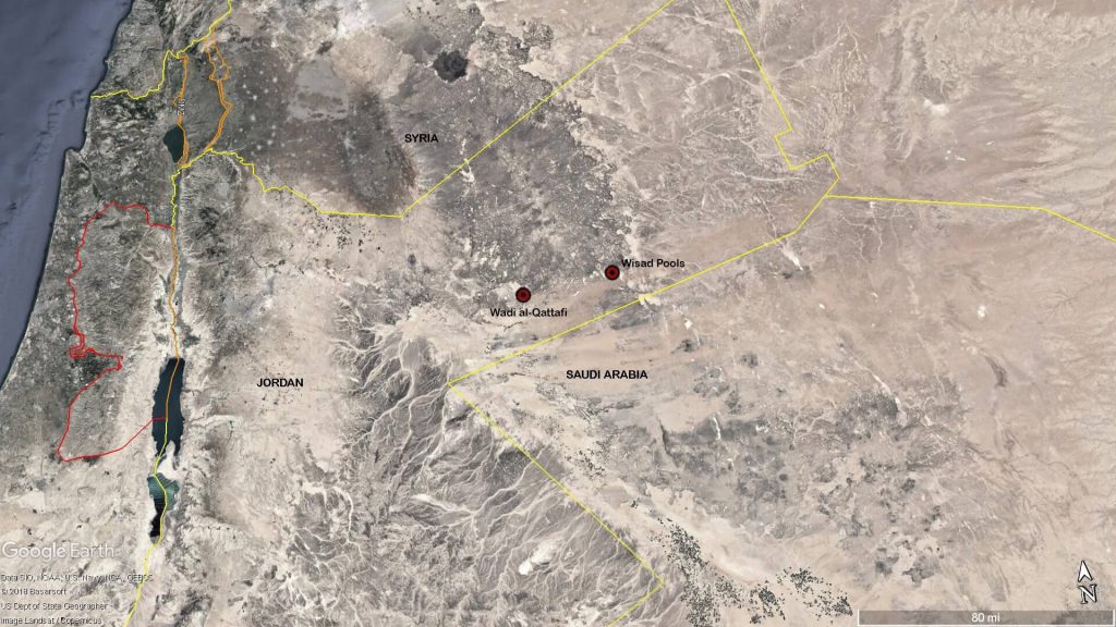
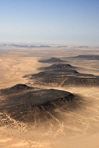
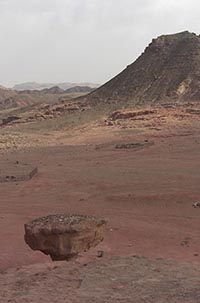
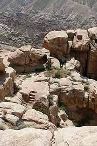
With both sites and presumably other unexplored concentrations of collapsed stone-built structures, the utilization of desert kites to hunt gazelle was a significant feature and attraction to the hunter-herders of the Black Desert. These dense concentrations have even been termed “mega-sites” by Gary Rollefson, who suggests that a significant component of the population from the Pre-Pottery Neolithic B villages (mega-sites) in the highlands of Jordan probably decamped to the eastern region of the Black Desert. The continued occupation and increasing construction into the Late Neolithic utilized innovations such as kites to establish lengthy periods of habitation. The apparent centrality of desert kites to the Late Neolithic exploitation of the Black Desert has inspired the conception of a new research initiative known as the “Kites in Context” project, directed by Chad Hill and myself to explore and document not only the kites but nearby associated structures and features. We hope to explore and better understand this foreboding landscape that was once a thriving hunter and herder savanna frontier full of wild and domestic animals.

Yorke Rowan is Research Professor at the Institute for Studies of Ancient Cultures at the University of Chicago. He is co-director of the Kites in Context project and the Eastern Badia Archaeological Project, both research projects in the Black Desert of eastern Jordan.


Further Reading

Crassard, R., et al. 2022 The Use of Desert Kites as Hunting Mega-Traps: Functional Evidence and Potential Impacts on Socioeconomic and Ecological Spheres. Journal of World Prehistory 35: 1-44.

Hill, A. C. and Y. M. Rowan. 2017.  Droning on in the Badia: UAVs and Large-Scale Site Documentation at Wadi al-Qattafi. Near Eastern Archaeology 80.2: 114-123.

Hill, A. C. and Y. M. Rowan. 2022. The Black Desert Drone Survey: New Perspectives on an Ancient Landscape. Remote Sensing 14(3). (Special Issue: Remote Sensing of Past Human Land Use.) DOI: 10.3390/rs14030702.

Hill, A. C., Rowan, Y. M., Wasse, A. and G. O. Rollefson. 2020. Inscribed Landscapes in the Black Desert: Petroglyphs and Kites at Wisad Pools, Jordan. Arabian Archaeology and Epigraphy 31(2): 245-262. doi.org/10.1111/aae.12158

Rollefson, G., et al. 2016   Investigations of a Late Neolithic Structure at Mesa 7, Wadi al-Qattafi, Black Desert, 2015. Neo-Lithics 1/16: 3-12.

Rollefson, G., Rowan, Y., and A. Wasse. 2014. The Late Neolithic Colonization of the Eastern Badia of Jordan. Levant 46(2): 285-301.

Rowan, Y. M., Rollefson, G. O., Wasse, A., Hill, A. C., and M. M. Kersel. 2017. The Late Neolithic Presence in the Black Desert. Near Eastern Archaeology 80.2: 102-113.

Rowan, Y. M., G. O. Rollefson, and A. Wasse. 2020. Populating the Black Desert. The Late Neolithic Presence. In P. M. M. G. Akkermans (ed.) Landscapes of Survival: Pastoralist Societies, Rock Art and Literacy in Jordan’s Black Desert.  Sidestone Press, pp. 59-77.

Click here for a PDF of this article. 

Want to learn more? Professor Rowan will be giving a webinar for the Friends of ASOR on this topic on October 19. Register Here!

Want To Learn More?

Late Prehistoric Pastoral Exploitation of Arid Lands in Jordan: New Light from the Black Desert

By Gary O. Rollefson

Jordan’s Black Desert is a uniquely harsh and inhospitable place. It is a broad band of basalt that stretches across Jordan’s panhandle, running some 145 kilometers from Azraq to its northeastern edge on the Iraqi border, and 115 kilometers from Syria in the north to Saudi Arabia in the south. In the summer and autumn, this region is bleak and forbidding – daytime temperatures regularly exceed 100 degrees F. Read More

A Desert Revolution – Transformations in Northwestern Arabia and the Arid Southern Levant in the Late 2nd Millennium BCE

By Juan Manuel Tebes

Archaeology speaks frequently about revolutions, but arid zones are left out of the discussion. But new evidence shows that deserts experienced their own momentous, if slower moving, revolutions. Read More

New Discoveries at Sela, the Mountain Stronghold of Edom

By Rocío Da Riva

High atop a rocky plateau in southern Jordan is an Iron Age site whose survival depended on water management. It seems an unlikely location, but the Babylonian king Nabonidus had no difficulty finding it. Read More

Not a Friend of ASOR yet? Sign up to receive ANE Today in your inbox weekly!