: A Window into Socio-Religious Change in Rural Roman Palestine")
: A Window into Socio-Religious Change in Rural Roman Palestine")
: A Window into Socio-Religious Change in Rural Roman Palestine")
: A Window into Socio-Religious Change in Rural Roman Palestine")
Not a Friend of ASOR yet? Sign up here to receive ANE Today in your inbox weekly!
: A Window into Socio-Religious Change in Rural Roman Palestine")
September 2023
Vol. 11, No. 9
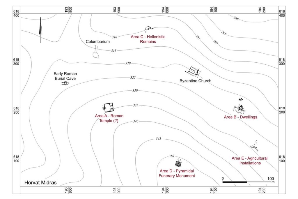


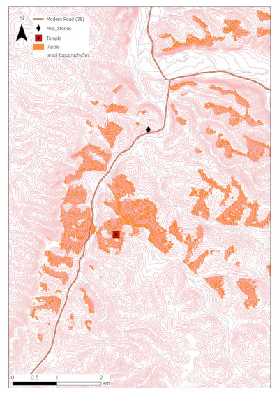
Figure 8: Topographic map showing visibility of the Roman temple at Horvat Midras (GIS analysis: I. Wachtel)
In any case, the village’s inhabitants certainly participated in the Second Revolt against Rome, the so-called Bar Kokhba Revolt (132–136 CE), as indicated by the construction of eight underground hiding complexes and several coins issued by the Judean rebel state headed by Simon Bar Kokhba (Figures 6 and 7). After the suppression of the Revolt, the village was again left uninhabited, as were other smaller Jewish villages in the vicinity. The religious and ethnic character of the site was again altered with the construction of what appears to be a temple or cultic complex on the western edge of the site, at a location overlooking the main road and seen from the road (Figure 8).
Previously identified by scholars as a synagogue, our excavations have instead suggested that this is one of the few temples known from rural Judea in the Roman period. The symmetrical ashlar-built complex (~20 X 20 m large) is nicely constructed and laid on bedrock (Figure 9). It comprises a raised, paved platform or podium accessed from the west via a wide staircase. On top of the podium, there is an open courtyard that drains into a large cistern north of the western staircase. At the eastern end of the courtyard, facing the western entrance, was probably a shrine of sorts. Unfortunately, only the supporting vaulted substructure survived, which was accessed via a staircase descending from the courtyard. The many architectural decorative pieces found in the collapse of the structure, including cornice pieces (Figure 10), a round niche, and an akroterion, support the notion that this complex included a small temple or a shrine.
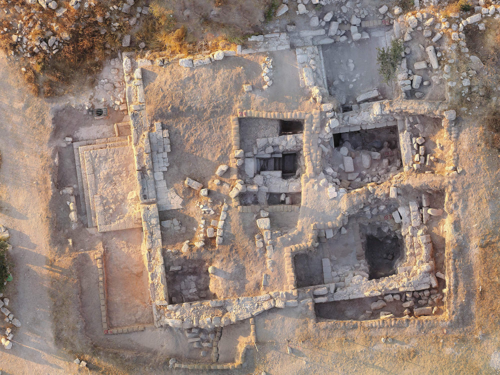
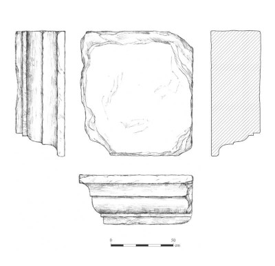
Figure 10: A molded cornice found collapsed at the foot of the southeastern corner of the monumental building in Area A (Drawing: D. Porotski)
Built on a monumental scale — like the pyramid — this temple was meant to be seen from a significant distance, including from the main road. While Hadrian’s expulsion of Jews from the Jerusalem area in the wake of the Second Revolt compelled Jews to leave the city and its environs, the construction of a prominent and visible temple in an area that was previously densely inhabited by Jews who took an active part in the war against the Romans was likely intended to visually mark Roman victory, as well as the regained control of the region by the Roman army. The establishment of the temple, moreover, was likely part of an act by the Roman authorities to re-settle non-Jewish groups in areas of Judea formerly inhabited by Jews. Evidence for this resettlement can be seen in other nearby sites, such as Khirbet Burgin and Horvat ‘Ethri.
The site’s religious identity continued to shift. The local population gradually became Christianized beginning in the fourth century CE and a church with remarkably well-preserved mosaic floors was built at the site in the fifth century. After the Arab conquest of Palestine and the gradual conversion to Islam under the Umayyads, a mihrab (prayer niche) facing south was added to the church. After a decline of the settlement in the Abbasid and Crusader periods, the Roman-period temple was re-purposed in the Mamluk period (or perhaps earlier under the Ayyubids), using its ashlars to construct a watchtower on top of the southwestern corner of the podium overlooking the road. Under the Mamluks, the village seems to have reclaimed its status as a particularly productive and possibly wealthy agricultural site (Figure 11), as suggested by census and tax records at the start of the Ottoman period. Later under Ottoman control, the site again showed signs of decline and eventually would cease to be used as a sedentary settlement. The site’s numerous ancient artificial caves and underground installations (columbaria, storage facilities, hiding complexes, burial caves, etc.) were used as shelters for shepherds, who built sheep sheds at the entrances to the caves. The abandoned site was described as ruins by the 19th-century explorer Victor Guérin, though he noted that the ancient wells continued to bring life to local flocks.
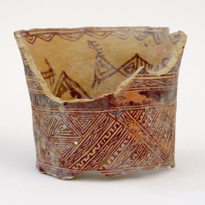
Figure 11: Mamluk-period jar neck (Photo: T. Rogovski)
What were the mechanisms that fostered the site’s changing identity? On the one hand, the site was abandoned several times, usually after a conquest or following a failed revolt. On the other hand, those who recognized the site’s fertility and agricultural potential seem to have been rewarded, as there are strong indications that when it was cultivated, Horvat Midras was particularly fertile and agriculturally productive. What initiated the village’s multiple re-settlements by successive ethnic-religious groups? What would repeatedly attract new inhabitants to an otherwise abandoned site? One wonders if, during a period of abandonment, the monumental structures that could be seen from afar sparked the curiosity of onlookers, causing them to wonder how such signs of wealth could exist in an otherwise non-descript location, perhaps beckoning them to take a closer look and leading them to discover the site’s rich potential. In any case, the site of Horvat Midras in many respects tells the story of the region and shows the importance of studying rural sites for understanding the history of ancient territories.
Orit Peleg-Barkat is Senior Lecturer in the Institute of Archaeology at the Hebrew University of Jerusalem. Gregg E. Gardner is Professor and Diamond Chair in Jewish Law and Ethics in the Department of Ancient Mediterranean and Near Eastern Studies at the University of British Columbia. They are co-directors of the Horvat Midras Excavations. Their article, “Conspicuous Construction: New Light on Funerary Monuments in Rural Early Roman Judea from Horvat Midras,” will be published in the journal BASOR later this year (Volume 391).
Acknowledgments:
We thank the Hebrew University of Jerusalem and the University of British Columbia for their continued support of this project, and to the undergraduate and graduate students from these two universities who participated in the excavation, including some as expedition staff. We would also like to thank the dozens of volunteers from Israel and abroad who have joined the excavation seasons.
The project was funded by the Israel Science Foundation, the Social Sciences and Humanities Research Council of Canada, the Roger and Susan Hertog Center for the Archaeological Study of Jerusalem and Judah, the International Catacomb Society, the Halbert Center for Canadian Studies at the Hebrew University, the Albright Institute for Archaeological Research, and the Israel Nature and Parks Authority.
Want To Learn More?
They Were Not Mainly “Peasants” Towards an Alternative View of Village Life in Greco-Roman Palestine and Egypt
By Sharon Lea Mattila
It has been very common for the vast majority of the people in the Greco-Roman world, with the exception of those who lived in the élite urban spheres, to be depicted as a homogeneous mass of “peasants”—members of subsistence-oriented, self-provisioning “peasant family farms,” living in tradition-bound, autarchic village communities, at slightly above subsistence after rents and taxes were paid. Market exchange, according to this received wisdom, was at best peripheral and indeed inimical to this “peasant” mode of existence. Instead, barter was supposedly the predominant and preferred means by which “peasants” exchanged their produce for the few necessities that they themselves could not produce. Read More
 Shikhin Between Jews and Romans
By James Riley Strange
Most archaeological sites in the ancient world are important for one reason or another. But every once in awhile, archaeologists uncover one that that helps them solve long-standing problems, or that opens up a new tin of questions that must be answered. Read more